Isle Of Skye Map | Regions, Towns, And Travel Routes
Make the most of your trip to the Isle of Skye with a map that shows all the best areas, routes, and hidden gems.
Author:Callum FraserJul 23, 202512.3K Shares280.4K Views
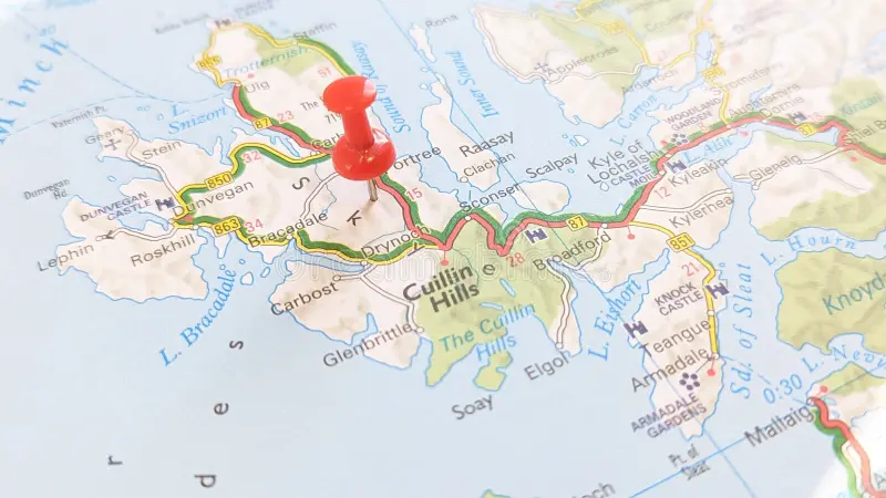
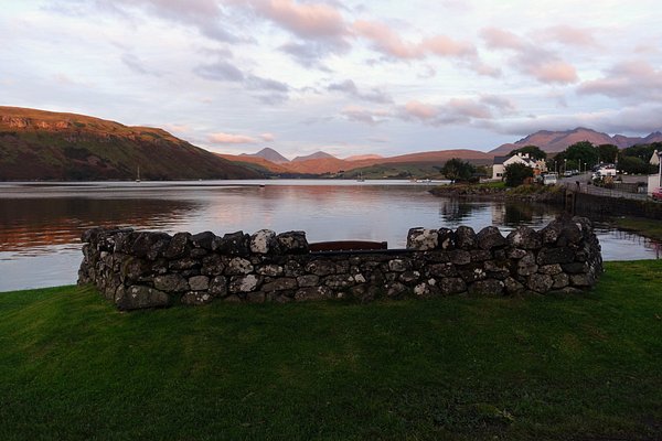
The Isle of Skye is one of Scotland’s most beautiful islands. It is famous for its wild mountains, deep lochs, and old castles. Many visitors come to see its amazing nature and rich history. But Skye can be hard to get around without the right map.
Roads are narrow, the weather changes quickly, and mobile signals are weak in many places. This article will help you understand why a good map is important and show you the best maps to use. With the right map, your trip to the Isle of Skye will be safer and more enjoyable.
Quick Facts About The Isle Of Skye
- Location: Off the west coast of mainland Scotland, part of the Inner Hebrides
- Famous For: Stunning landscapes, the Cuillin mountains, fairy pools, and dramatic coastline
- Name Meaning: "Skye" may come from the Norse word Skuy, meaning "cloud island"
- Population: Around 10,000 people
- Main Town: Portree, known for its colorful harbor and as a base for visitors
- Access: Reachable by the Skye Bridge from the mainland or by ferry
- Historic Sites: Includes Dunvegan Castleand the ruins of Armadale Castle
- Wildlife: Look out for red deer, sea eagles, otters, seals, and sheep
- Popular Activities: Hiking, photography, road trips, and visiting local villages
- Weather: Often rainy and windy, but also offers beautiful light and dramatic skies
- Famous Film Locations: Featured in movies like Prometheus, The BFG, and Stardust
Geographical Overview Of The Isle Of Skye
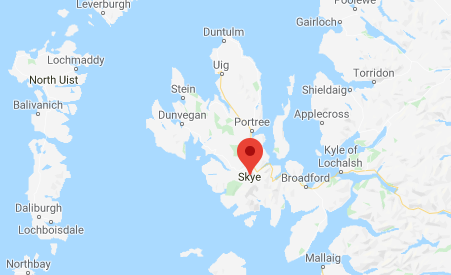
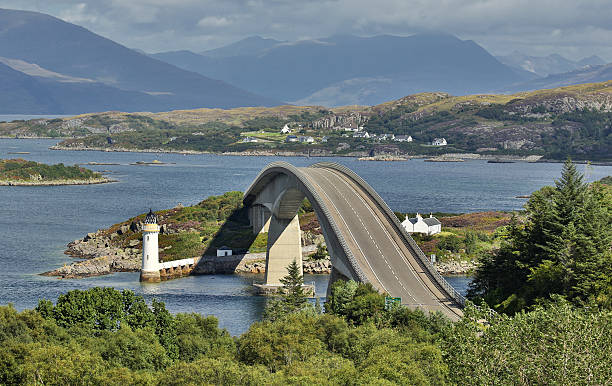
The Isle of Skye is the largest island in the Inner Hebrides, off mainland Scotland's west coast. It stretches about 50 miles (80 km) from north to south and is known for its deeply indented coastline, which gives it a rugged, irregular shape. Skye is connected to the mainland by the Skye Bridge, near the village of Kyle of Lochalsh.
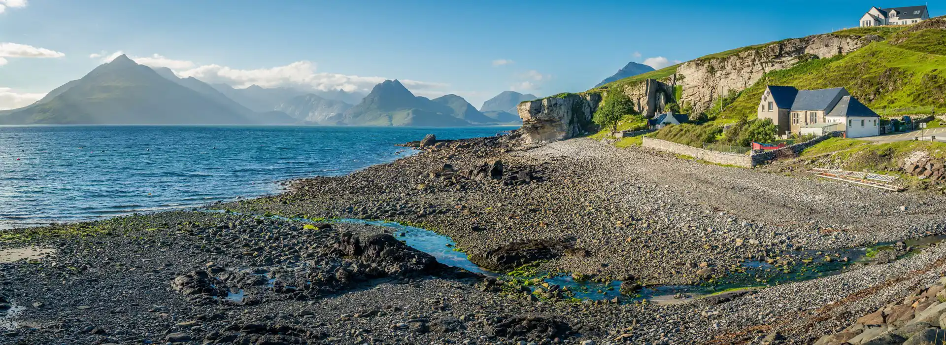
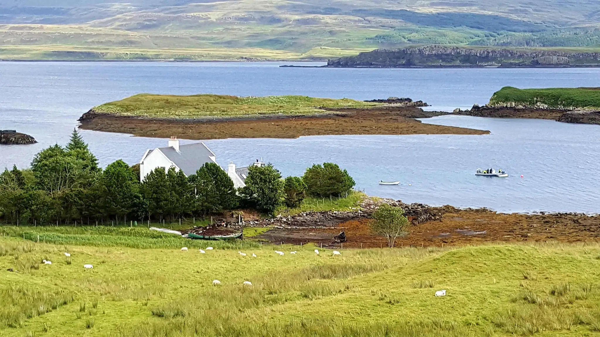
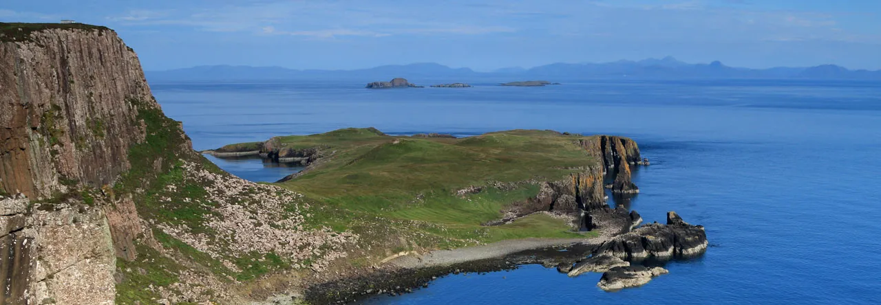
Dramatic natural features mark the landscape. In the north, you'll find the Trotternish Ridge, home to iconic landmarks like the Old Man of Storr and the Quiraing. In the south, the Black Cuillin and Red Cuillin mountain ranges create steep peaks and deep glens, popular with walkers and climbers. Inland areas are filled with lochs, moorland, and forests, while the coastline features cliffs, sea stacks, and sandy bays.
Skye’s terrain was shaped by volcanic activity and glaciation, giving it a mix of sharp cliffs, rolling hills, and dramatic rock formations. The island's highest point is Sgùrr Alasdair in the Cuillin range, which stands at 992 meters (3,255 feet).
Why You Need A Map On The Isle Of Skye
While modern technology offers various navigation tools, the Isle of Skye presents unique challenges that make traditional maps indispensable.
- Limited Mobile Signal: Many parts of Skye have poor or no mobile reception, making digital maps unreliable.
- Remote Terrain: The island's vast landscapes include areas with few signposts or landmarks.
- Weather Conditions: Fog and rain can obscure visibility, making it easy to lose your way.
- Safety: In emergencies, a physical map can be a lifesaver when electronic devices fail.
Having a detailed map ensures you can plan your routes, identify key landmarks, and navigate safely through Skye's diverse terrains.
History Of Isle Of Skye
The Isle of Skye has a long and rich history that goes back thousands of years. Early settlers lived on the island during the Stone Age, leaving behind stone circles and burial sites. Later, Skye became part of the ancient Gaelic kingdom of Dál Riata and was later influenced by Norse rule, as Vikings settled and controlled the area for many years. The island was then ruled by powerful Scottish clans, especially Clan MacLeod and Clan MacDonald, who built castles and fought over land and power.
During the 18th century, after the Jacobite uprisings, many people were forced off the land in what became known as the Highland Clearances. This caused a big drop in the population. Today, the history of Skye can still be seen in its castles, ruins, and strong local traditions, which are deeply connected to Scottish culture.
Capital Of Isle Of Skye
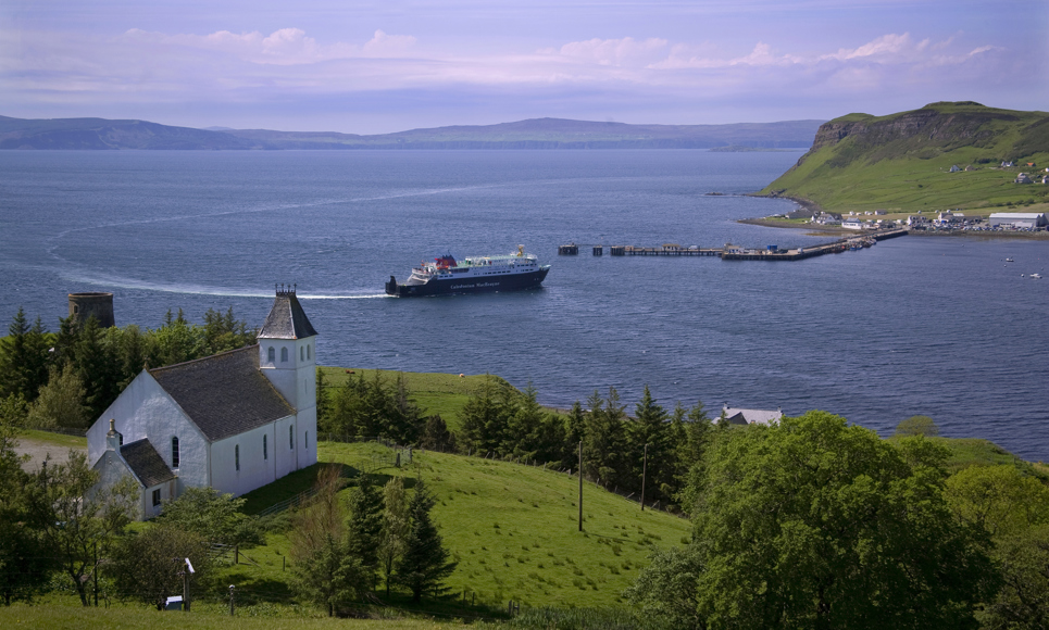
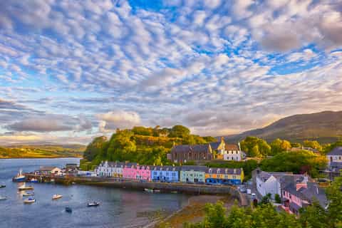
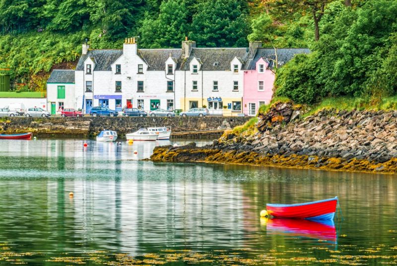
The capital of the Isle of Skye is Portree. Portree is the largest town on the island and serves as its main hub for tourism, transport, shopping, and local services. It sits on the east coast of Skye and is known for its colorful harbor, surrounding hills, and access to many of the island’s top attractions. Portree is also a good base for exploring other parts of the island, offering a range of accommodations, restaurants, and tour services.
Regions On The Isle Of Skye
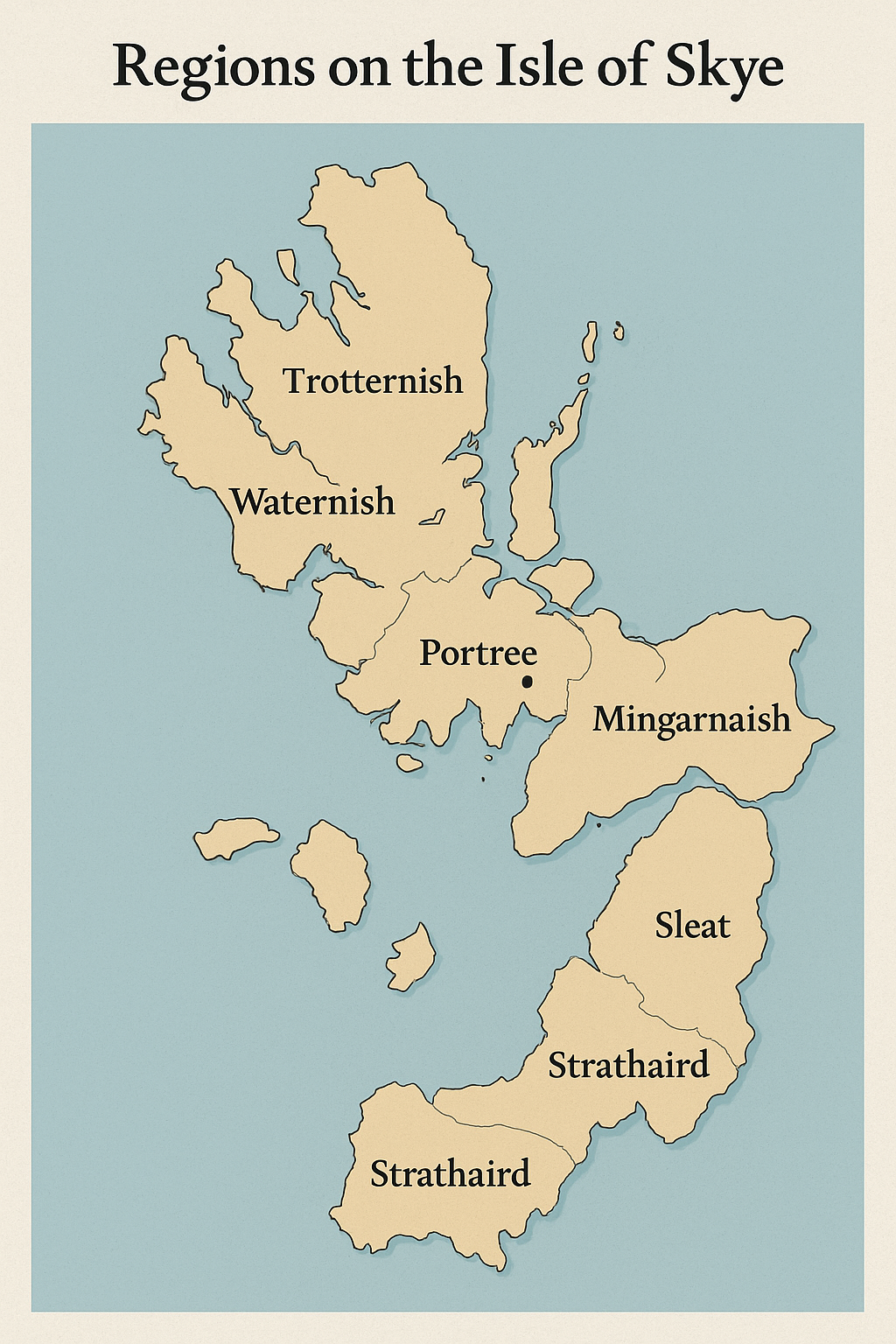
Trotternish Peninsula
Trotternish is the northernmost region of the Isle of Skye. It is famous for its dramatic cliffs and unusual rock formations. The most well-known sites here are the Old Man of Storr, a tall, pointed rock that looks like a giant finger, and the Quiraing, a landslip that creates strange hills and valleys. This area is great for hiking and photography. The landscape changes quickly from green fields to cliffs overlooking the sea. Small villages like Uig and Staffin offer places to stay and eat, with Uig also acting as a ferry point to the Outer Hebrides.
Duirinish
Duirinish lies on the northwest coast of Skye. This region is more remote and wild, offering beautiful coastal views and quiet spots. The village of Dunvegan is in Duirinish and is famous for Dunvegan Castle, the oldest continuously inhabited castle in Scotland. The area is less crowded and perfect for travelers who want to enjoy peaceful walks and see wildlife like seals and birds along the coast.
Waternish
Waternish is located west of Trotternish and is known for its quiet charm and traditional villages. The landscape here includes gentle hills, farmland, and rocky shores. Villages such as Stein and Dunvegan are in this region. Waternish is a great place for visitors who want to enjoy fresh seafood, walk along peaceful paths, and learn about local history and culture.
Sleat Peninsula
Sleat is often called the “Garden of Skye” because it has more trees and softer hills than other parts of the island. It is in the south of Skye and offers a milder climate and green landscapes. The main village is Armadale, which has a ferry connection to the mainland. Sleat is perfect for gentle walks, visiting gardens like Armadale Castle Gardens, and enjoying quiet beaches. It is less busy than northern parts of the island, making it ideal for relaxing.
Minginish
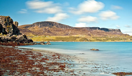
Minginish covers the central southern part of Skye. This region is famous for the Cuillin Mountains, some of the most rugged and beautiful peaks in Scotland. Minginish is popular with climbers and serious hikers who want to challenge themselves. The village of Elgol is on the coast here, offering stunning views of the mountains and boat trips to nearby sea lochs. The area is wild and dramatic, with many outdoor adventure opportunities.
Strathaird
Strathaird lies to the east of Minginish and is part of the central southern area of Skye. It shares much of the same rugged and mountainous terrain. This region is less visited but offers excellent hiking routes and peaceful countryside. Strathaird is perfect for people who want to get away from busy tourist spots and enjoy Skye’s natural beauty in quiet surroundings.
Main Towns And Villages On The Isle Of Skye
Portree
Portree is the largest town on the Isle of Skye and its main center for shopping, dining, and accommodation. It sits on the east coast, around a natural harbor with colorful buildings that make it very picturesque. Portree is often the first stop for visitors because it has many services like shops, restaurants, and bus connections. The town is also close to famous natural sights such as the Old Man of Storr and the Quiraing.
Dunvegan
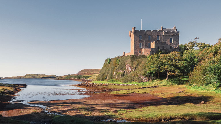
Dunvegan is a small historic village on the northwest coast of Skye. It is best known for Dunvegan Castle, which has been the home of the MacLeod clan for centuries. The village offers a peaceful setting with stunning views over the sea and nearby islands. Dunvegan is a good base for exploring the rugged coast and learning about Skye’s history.
Uig
Uig is a quiet village on the northern coast of the island. It is an important ferry port connecting Skye to the Outer Hebrides (specifically to the islands of Lewis and Harris). Uig is surrounded by beautiful beaches and rolling hills, making it a great place to enjoy nature. It’s also close to the Trotternish Ridge, a popular hiking area.
Broadford
Broadford is the second largest settlement on Skye, located on the east coast, south of Portree. It has a range of shops, cafes, and accommodation options, making it a useful place for visitors to stay. Broadford is close to the Cuillin Mountains, so many hikers and climbers use it as a base. It also has a ferry link to the mainland at Mallaig.
Armadale

Armadale is a small village on the southern tip of the Sleat Peninsula. It is known for the ruins of Armadale Castle and its beautiful gardens. Armadale also serves as a ferry port with regular sailings to the mainland, making it an important transport link. The village is surrounded by quiet countryside and peaceful beaches.
Staffin
Staffin is a village on the northeast coast in the Trotternish area. It is famous for its nearby dinosaur footprints found in the local cliffs, which attract visitors interested in geology and history. Staffin is a quiet, rural place with a strong community and stunning coastal views.
Elgol
Elgol is a small, remote village on the south coast of the Minginish region. It offers some of the best views of the Cuillin Mountains and is the starting point for boat trips to Loch Coruisk, a beautiful sea loch surrounded by high peaks. Elgol is peaceful and ideal for visitors looking to get away from crowds.
Carbost
Carbost lies on the west coast, near the famous Talisker Distillery, where visitors can taste some of Skye’s best whisky. The village is small but lively, with a few cafes and pubs. Carbost is a popular stop for those touring the island’s west coast and offers beautiful views of Loch Harport.
Glendale
Glendale is a group of small villages and crofts on the northwest coast in the Duirinish region. It is a quiet and remote area with strong Gaelic traditions. Glendale is a good place to experience rural life on Skye and enjoy peaceful walks in natural surroundings.
Kyleakin
Kyleakin is a village on the eastern side of the island, close to the Skye Bridge that links the island to mainland Scotland. It has a small harbor and is known for its local history and folklore. Kyleakin offers some shops and places to eat, serving as a convenient entry point for visitors arriving by car.
There are many small hamlets, crofting communities, and scattered houses rather than larger towns.
Some smaller places you might hear about include:
- Kilmaluag(small village near Trotternish)
- Camuscross(a crofting community on the Waternish peninsula)
- Edinbane(a village between Portree and Dunvegan)
- Sleat Village(small settlement on the Sleat peninsula)
- Borreraig(known for traditional piping school in Waternish)
These are mostly tiny, quieter spots with a few houses or farms, not big enough to be called towns but still part of Skye’s rich local landscape.
Total Area Of Isle Of Skye
The Isle of Skye covers a total area of around 1,656 square kilometers (639 square miles), making it the second-largest island in Scotland after Lewis and Harris. Its size allows for a wide variety of landscapes, from rugged mountain ranges and deep sea lochs to sweeping moorlands and dramatic coastlines.
The island’s irregular shape, formed by ancient volcanic activity and glacial erosion, creates a long and winding coastline that adds to its wild and remote character. Despite its size, Skye has a small population, with large areas remaining untouched and rich in natural beauty.
Population Of Isle Of Skye
The Isle of Skye has a population of approximately 13,143 people, reflecting a steady increase in recent years. This growth is driven by factors such as tourism, new job opportunities like whisky production, and the rise of remote work.
The largest town, Portree, is home to nearly 2,500 residents, while other settlements like Broadford and Kyleakin also contribute to the island’s community. After a historical decline due to events like the Highland Clearances, Skye’s population is now gradually growing, supporting a vibrant local economy and culture.
Government And Politics Of The Isle Of Skye
The Isle of Skye is part of Scotland and falls under the administration of the Highland Council, which is based in Inverness. Local decisions on things like roads, education, and housing are managed by this council. Skye also has community councils that help give a voice to residents on issues specific to their towns and villages.
In terms of national government, Skye is represented in both the Scottish Parliamentand the UK Parliament through larger regional constituencies. Local politics often focus on tourism, transportation, housing, and preserving the natural environment.
Language Of The Isle Of Skye
The main language spoken on the Isle of Skye is English, but Scottish Gaelicalso has a strong presence. Gaelic has been spoken here for centuries, and some people on the island still use it in daily life. You’ll often see road signs and place names written in both English and Gaelic. In recent years, there has been a push to keep Gaelic alive, with schools offering lessons and local groups promoting its use through music, events, and festivals.
Economy Of The Isle Of Skye
The economy of the Isle of Skye mainly depends on tourism, which brings thousands of visitors each year. People come for the scenery, history, and outdoor activities, supporting local hotels, restaurants, shops, and tour services. Other important parts of the economy include fishing, crofting (small-scale farming), and whisky production, especially from the well-known Talisker Distillery. Some locals also work in crafts, selling handmade goods to visitors. In recent years, digital businesses and remote work have started to grow, thanks to improved internet access.
Types Of Maps For The Isle Of Skye
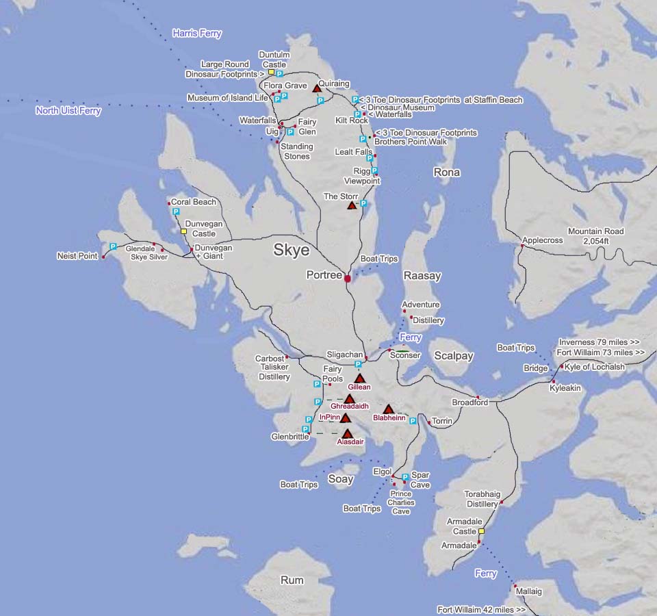
Paper Maps
Paper maps are reliable and don’t need batteries or internet access, which makes them ideal for remote areas on Skye.
OS Explorer Maps (1:25,000 Scale)
These maps are perfect for walkers and hikers. They show footpaths, contours, elevation changes, and key landmarks in great detail. The scale allows you to see the landscape up close, which is helpful when navigating tricky or less-marked trails. Some Explorer maps for Skye include:
- EX407 (Dunvegan)
- EX408 (Trotternish)
- EX409 (Raasay, Rona & Scalpay)
- EX410 (Portree & Bracadale)
- EX411 (Cuillin Hills)
- EX412 (Sleat)
OS Landranger Maps (1:50,000 Scale)
These maps cover a larger area with less detail and are better for drivers and cyclists. They still show roads, towns, and key natural features but with fewer walking paths than the Explorer series. Useful Landranger maps for Skye include:
- LR 23 (North Skye)
- LR 32 (South Skye & Cuillins)
Digital Maps
Digital maps are great for people who prefer using smartphones or tablets. They offer features like GPS tracking, route planning, and offline access.
- Google Maps: Good for road navigation and general orientation, but it may miss small footpaths or remote trails.
- Maps.me: Offers detailed walking routes and allows you to download maps for offline use. Handy in areas with no signal.
- ViewRanger: Excellent for outdoor adventures. It shows topographic maps and lets you track your walk using GPS.
- OS Maps App: This is the digital version of Ordnance Survey’s paper maps. It gives access to both Explorer and Landranger maps on your device.
Specialized Maps
These maps are designed for specific purposes and can be very helpful for certain activities.
Skye Trail Map
Covers the entire 127-kilometer Skye Trail, a long-distance route for experienced hikers. It shows campsites, trail stages, and terrain features.
Footprint Visitor Map
A waterproof tourist map that marks key attractions, accommodations, walking routes, and practical information like parking areas. It’s easy to carry and great for sightseeing.
Tourist Areas To Visit On The Isle Of Skye
1. The Old Man Of Storr
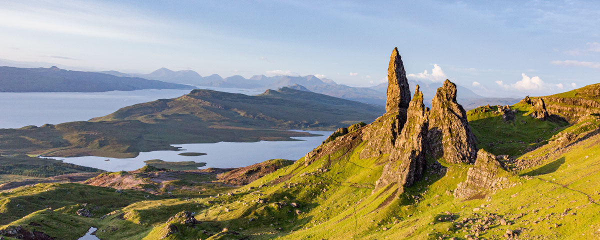
This towering rock formation is one of Skye’s most iconic sights. The Old Man of Storr sits on the Trotternish Ridge and stands out for its jagged, dramatic shape. Walking up to it takes about 1-2 hours, with paths shown clearly on detailed maps. The views from the top are amazing, overlooking the Sound of Raasay and the surrounding landscape. It’s a favorite for photographers, especially at sunrise.
2. Quiraing
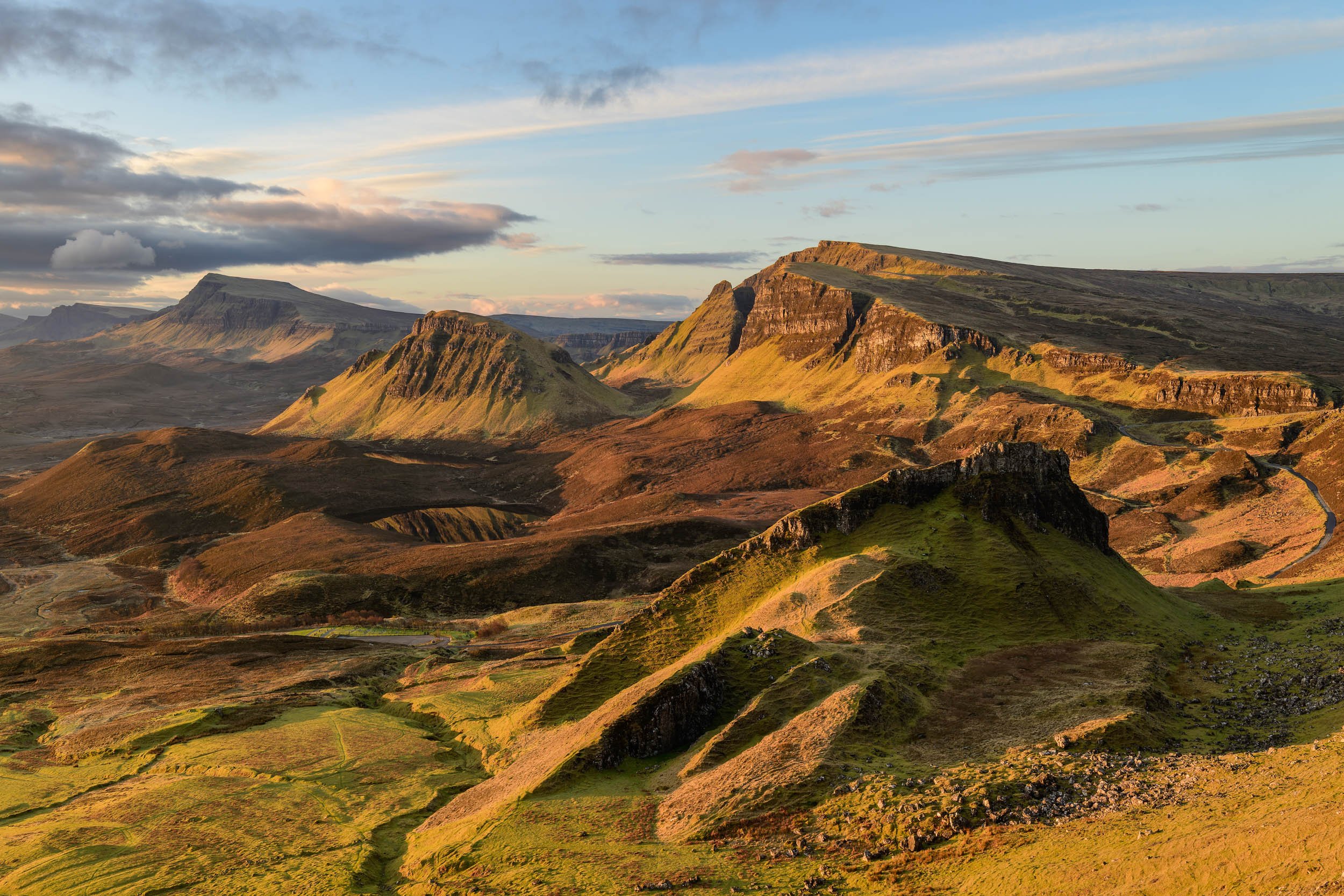
The Quiraing is a landslip that creates a strange and beautiful landscape of cliffs, plateaus, and pinnacles. It’s perfect for hikers who want both challenge and incredible views. The trail loops through grassy hills and past dramatic rock formations. This area is found on OS Explorer maps and is often described as otherworldly due to its unique geology.
3. Fairy Pools
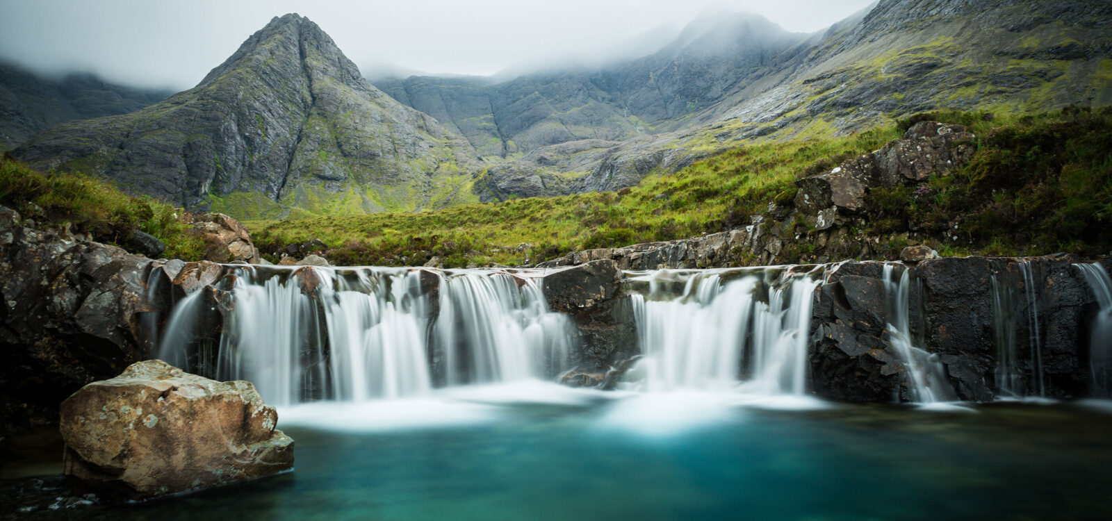
Located near Glenbrittle, the Fairy Pools are a series of crystal-clear blue pools and waterfalls formed by mountain streams. The pools are famous for wild swimming and photography. Hiking here is relatively easy and mapped well on Explorer maps. The area is magical in both summer and winter, with snow or sunshine enhancing the natural beauty.
4. Dunvegan Castle
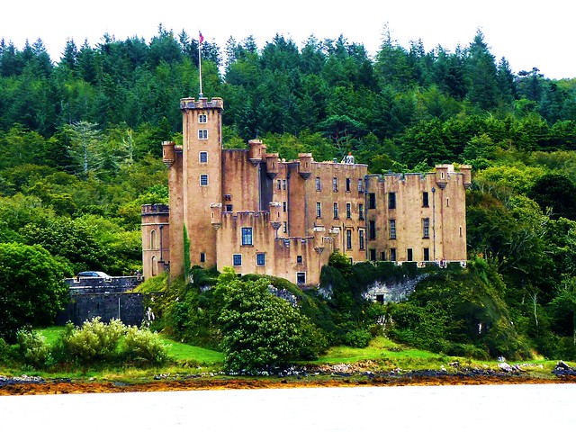
Dunvegan Castle is the oldest continuously inhabited castle in Scotland and the ancestral home of the MacLeod clan. It sits on a sea loch and has beautiful gardens open to visitors. The castle’s history dates back over 800 years, and inside, you can see historic artifacts and clan relics. The castle and grounds are marked on the EX407 map and are a cultural highlight on the island.
5. Neist Point Lighthouse
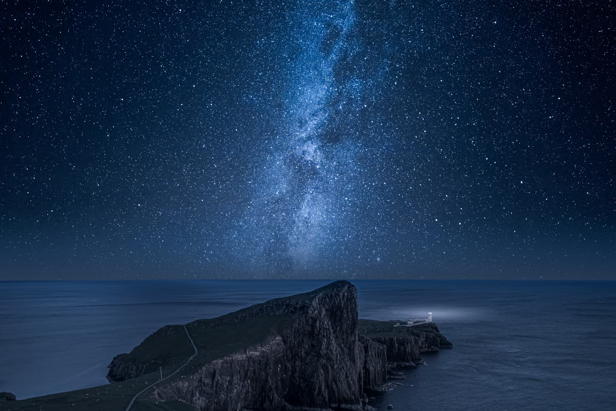
Sitting on the westernmost tip of Skye, Neist Point Lighthouse offers stunning cliff views and a chance to spot whales, dolphins, and seabirds. The walk down to the lighthouse is steep but manageable, and the lighthouse itself is a perfect subject for photography. The site is marked on most road maps and is a popular spot for sunset watchers.
6. Portree
Portree is the island’s largest town and serves as the main hub for travelers. It has a picturesque harbour lined with colorful buildings, shops, restaurants, and accommodations. Portree is often the starting point for day trips and is easy to find on any map. It also offers ferry connections to the mainland and other islands.
7. The Fairy Glen
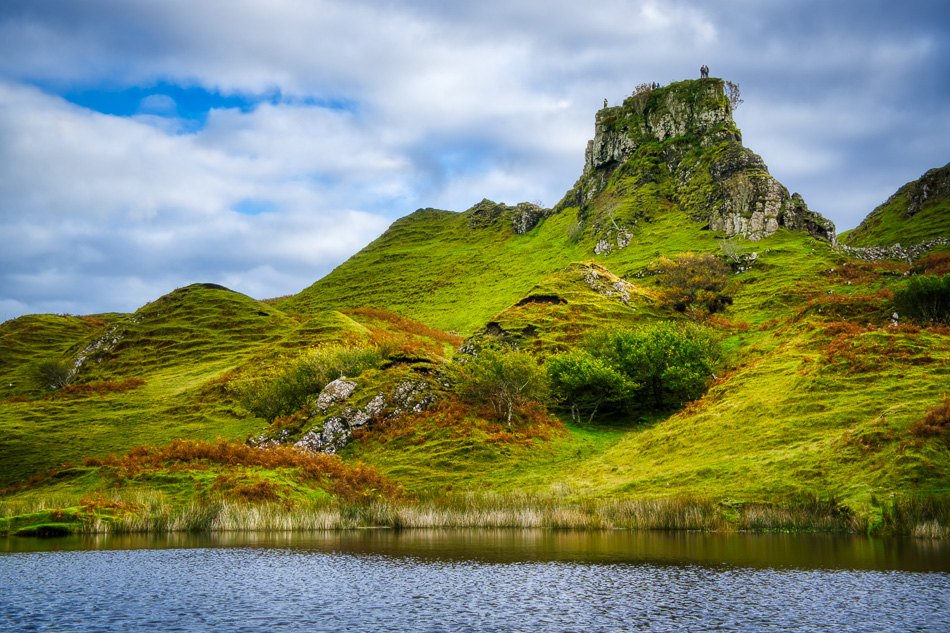
The Fairy Glen is a small valley near Uig that looks like something out of a fairy tale, with strange grassy hills, small ponds, and cone-shaped mounds. It’s a peaceful place to wander and imagine myths coming to life. The paths aren’t well marked on digital maps but are visible on paper Explorer maps. It’s perfect for gentle walking and enjoying nature’s whimsy.
8. Elgol

Elgol is a small, quiet village on the southern coast of Skye, known for its stunning views of the Cuillin mountains across Loch Scavaig. The drive to Elgol is scenic, passing sea lochs and rugged landscapes. Visitors often take boat trips from Elgol to Loch Coruisk, a hidden freshwater loch surrounded by dramatic peaks. The village and route are marked on road and visitor maps.
9. Talisker Bay
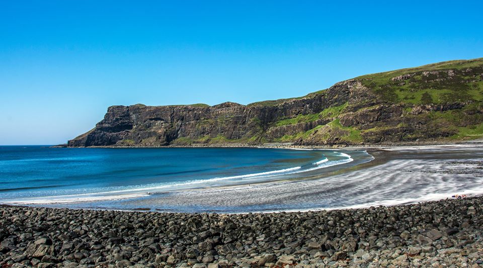
Talisker Bay is famous for its striking black sand beach and impressive sea stacks. It’s near the village of Carbost, home to the Talisker Distillery. The beach is accessible via a short walk from the parking area, and the dramatic coastline is ideal for photography and quiet reflection. Maps mark this location clearly, especially those focusing on the south-west of the island.
10. Talisker Distillery
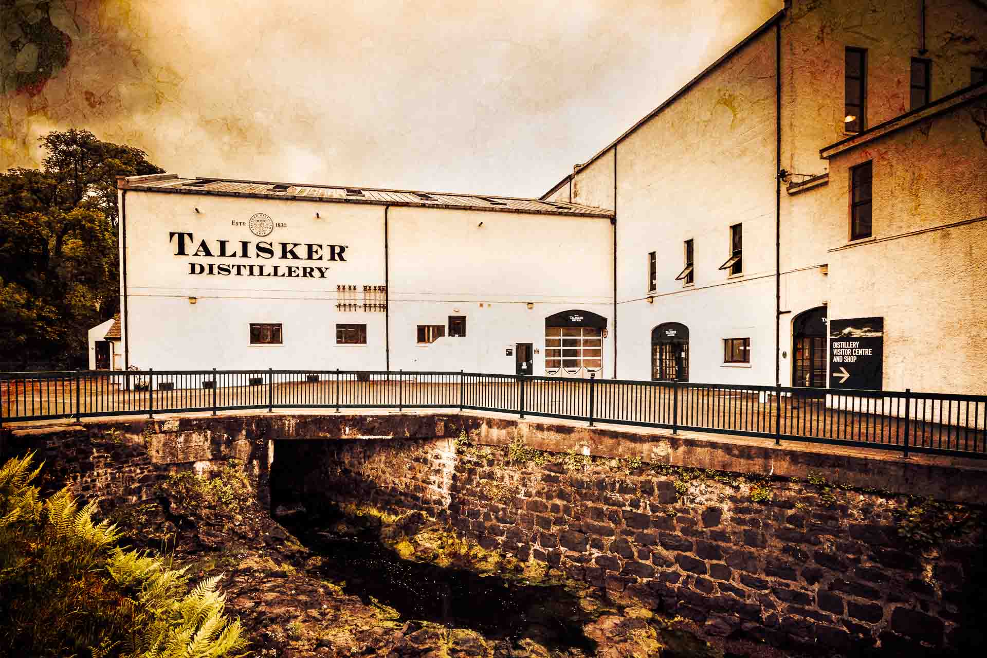
The Talisker Distilleryis the only whisky distillery on the Isle of Skye and produces some of Scotland’s most famous single malts. It offers tours and tastings, giving visitors insight into the whisky-making process. Located in Carbost, the distillery is easy to find on local maps and is a must-visit for whisky lovers.
11. Sligachan Old Bridge
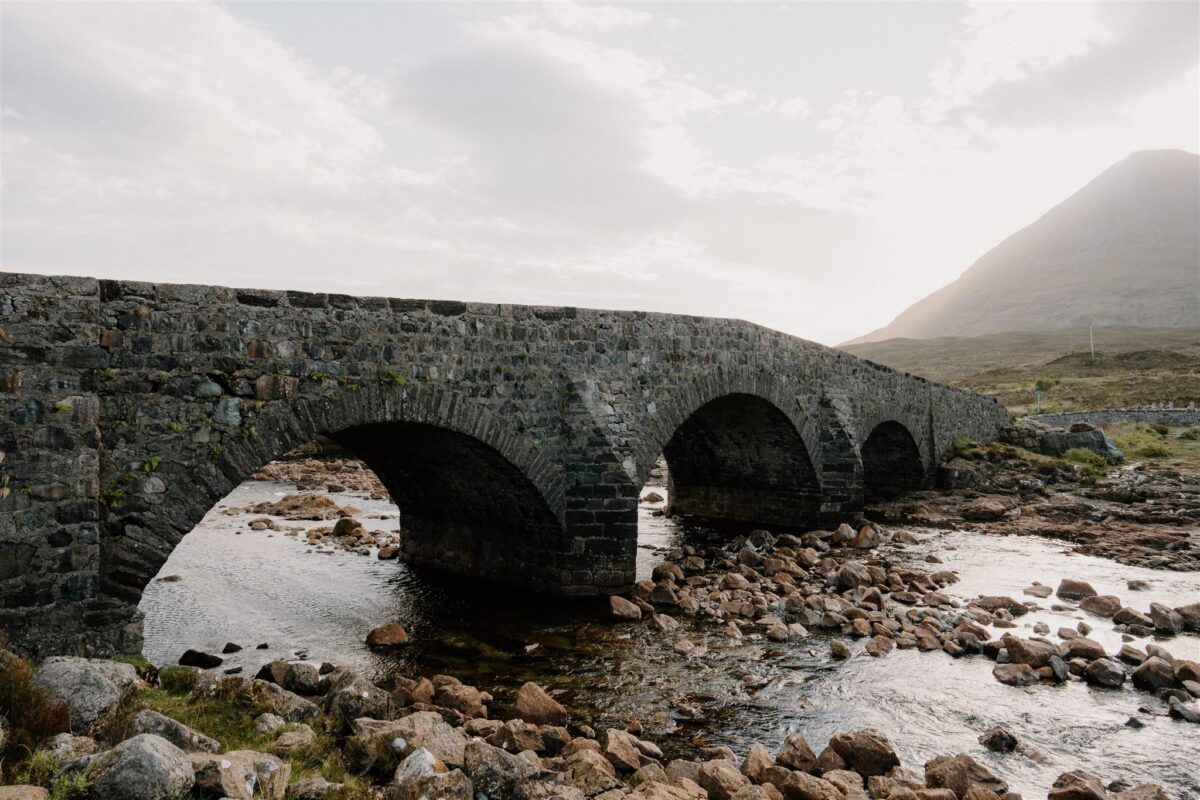
This historic stone bridge crosses the River Sligachanand is set against the stunning backdrop of the Cuillin mountain range. It’s a popular meeting point for climbers and hikers heading into the mountains. The area around the bridge has marked trails and is shown on all detailed walking maps. The combination of history and scenery makes it a favorite photo spot.
12. Staffin Beach & Dinosaur Footprints
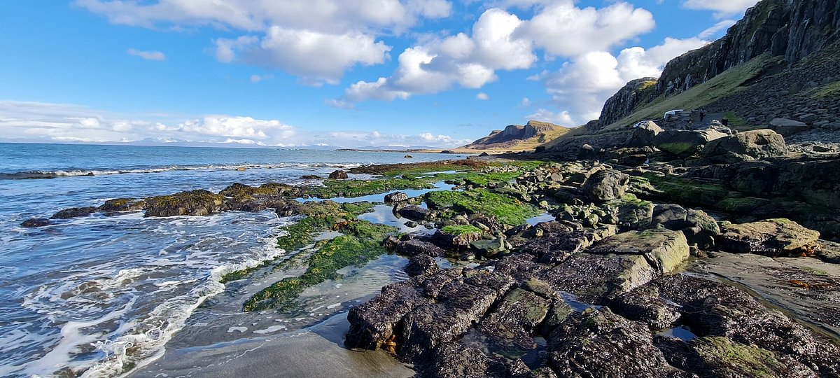
At Staffin Beach, visitors can see real dinosaur footprints preserved in the rocks at low tide. The footprints date back millions of years, making this a unique place to connect with ancient history. The beach and village are located on the northeast coast and marked on most maps. Guided tours are sometimes available to explain the footprints’ significance.
13. Rubha Hunish
Rubha Hunish is the northernmost point of Skye, located on the tip of the Trotternish Peninsula. This remote spot is great for peaceful walks, wildlife watching, and enjoying wide views of the sea and surrounding islands. The walk to Rubha Hunish is shown on Explorer maps and offers a quiet alternative to busier areas.
14. Kilt Rock And Mealt Falls
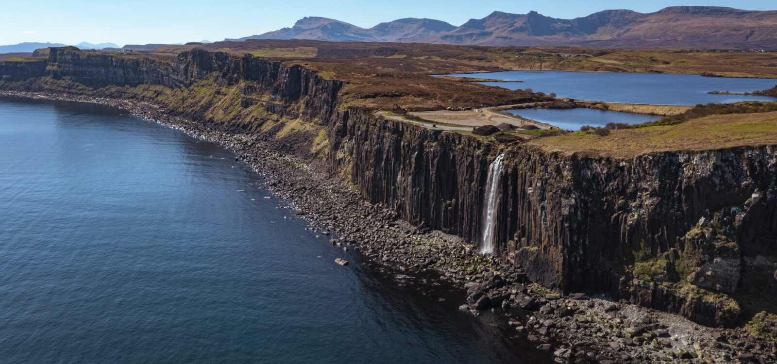
Kilt Rock is a dramatic cliff formation that resembles a pleated kilt. Next to it is Mealt Falls, a waterfall that plunges straight into the sea below. This viewpoint is easily accessible by car and is a popular stop on scenic drives around Skye. The site is clearly marked on road maps and is perfect for short visits and photos.
15. Armadale Castle And Gardens
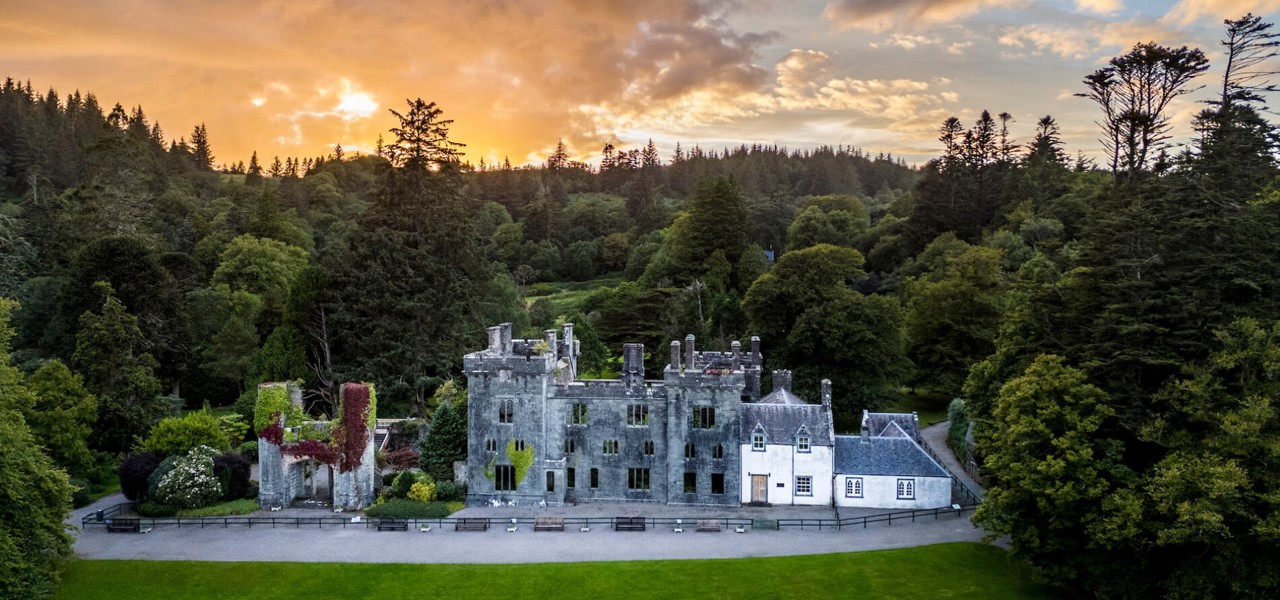
Located in the Sleat Peninsula, Armadale Castle is surrounded by beautiful gardens and woodland walks. The castle ruins are linked to Clan Donald history and include a museum that tells the story of the clan’s influence in Scotland and overseas. The gardens offer a peaceful retreat, and the area is well marked on visitor maps.
Planning Routes With Your Map
Using your map effectively is key to planning the best routes around the Isle of Skye. Whether you are driving, hiking, cycling, or taking a boat, knowing your options helps you make the most of your visit.
Driving Routes
Skye’s roads range from narrow single-track lanes to well-maintained main roads. When planning your driving route, it’s important to consider both traveltime and scenic value. The Skye Bridge connects the island to the mainland and serves as the main entry point. From here, one popular route is the drive to Uig, which links several important towns and offers access to northern parts of the island.
For scenic drives, consider the Trotternish Loop a circular route that passes famous landmarks like the Quiraing and the Old Man of Storr. The Sleat Peninsula in the south is another beautiful area to explore by car, with quiet roads and coastal views.
Walking And Hiking Trails
Skye is famous for its outstanding walking trails suited for different levels of fitness. The Old Man of Storr is a must-visit, offering a 4.5 km trail with an ascent of 288 meters. It typically takes about 1.5 to 2 hours to complete and rewards hikers with stunning views of the rugged landscape.
The Fairy Pools, located near Glen Brittle, feature a shorter 2.4 km walk leading to natural pools and waterfalls with crystal-clear water, perfect for photography and relaxing stops. For more experienced hikers, Bla Bheinn (also called Blaven) is a challenging 7 km trek that climbs 928 meters. It offers breathtaking panoramic views but requires good fitness and preparation.
Cycling Routes
Cycling is another great way to enjoy Skye’s natural beauty. One recommended route runs from Broadford to Elgol, covering 24 km along coastal roads with spectacular sea views.
This ride offers a mix of gentle terrain and moderate climbs. Another popular cycling route connects Portree, the island’s largest town, to Dunvegan, about 35 km. This route passes through diverse landscapes, including farmland, hills, and small villages, making it perfect for a day trip by bike.
Boat And Ferry Crossings
If you want to include boat travel in your itinerary, there are key ferry routes to note. The ferry from Mallaig to Armadale connects Skye to the Scottish mainland, providing access for visitors coming from the south.
Another important ferry runs from Uig on Skye to Tarbert on the Isle of Harris, linking Skye with the Outer Hebrides. These ferry routes are essential for travelers planning multi-island trips and offer unique views of the surrounding seascape.
How To Use Isle Of Skye Map For Travel
Choose The Right Map For Your Needs
When travelling around the Isle of Skye, it’s important to pick a map that matches how you plan to get around. For driving, OS Landranger maps with a 1:50,000 scale are a good choice because they show wider areas, making it easier to plan long-distance routes. If you’re walking or hiking, OS Explorer maps (1:25,000 scale) or digital options like the OS Maps app, ViewRanger, and Maps.me offer more detail, showing footpaths, terrain, and elevation.
Mark Your Key Locations
Before your journey, take time to look at your map and mark the places you really want to visit. These may include towns such as Portree, Broadford, and Dunvegan, as well as natural landmarks like the Old Man of Storr, the Fairy Pools, and Neist Point. You can also mark ferry ports at Armadale and Uig if you plan to travel to or from the island by sea. This will help you understand how far apart these places are and how long it might take to travel between them.
Plan Routes Based On Terrain And Travel Type
The Isle of Skye has a mix of roads and landscapes, so plan your route based on how you’re travelling. For driving, remember that some roads are narrow and single-track, especially in the countryside. Routes like the Trotternish Peninsula Loop are known for their beautiful views and are popular with drivers. If you’re hiking, use a detailed map to check elevation and terrain. Walks such as Bla Bheinn or the Quiraing need more planning due to their difficulty. For cycling, choose quieter roads and be ready for hills. A route like Broadford to Elgol is a favourite for its coastal views and open spaces.
Download Offline Maps
Many parts of Skye have weak or no phone signal, especially in the hills and remote areas. To avoid getting lost, download your maps before you go. Apps like Google Maps, Maps.me, and OS Maps allow you to save routes offline. This way, even without internet access, you can still use your phone to follow your route or find your location.
Use Ferry Maps If Travelling Beyond Skye
If your trip includes travel to or from the mainland or the Outer Hebrides, include ferry routes in your travel planning. The ferry from Mallaig to Armadale connects Skye to the mainland, while the Uig to Tarbert route links Skye with the Outer Hebrides. Look at these routes on your map and check ferry schedules in advance, as sailings can be affected by weather. Mark the ports and times clearly to stay on track during your journey.
Keep A Paper Map As Backup
Even if you rely on your smartphone or GPS device, it’s smart to carry a paper map. Technology can fail, especially in bad weather or if your battery runs out. A paper map is always reliable, especially for hiking or when you’re far from towns or roads. It gives you peace of mind and keeps you safe.
Adapt On The Go
Sometimes, plans change. Weather, road closures, or unexpected events can affect your schedule. Your map will help you make changes easily. You can find nearby places to visit, take a different walking path, or choose another road to avoid problems. Being flexible and knowing how to use your map well will make your trip more enjoyable and less stressful.
How To See The Best Of Isle Of Skye In 3 Days
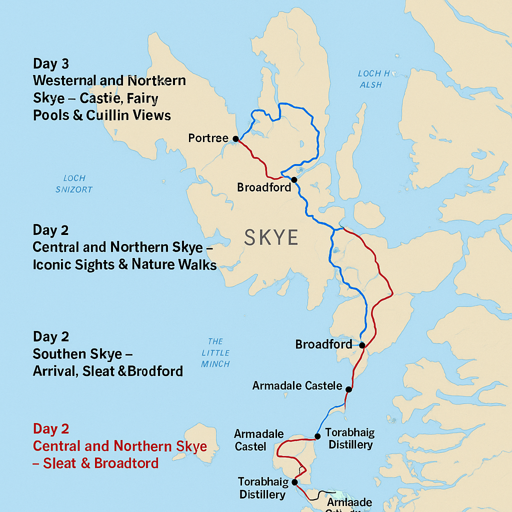
Day 1: Southern Skye - Arrival, Sleat & Broadford
Start your journey by arriving via the Skye Bridge or the Armadale ferry. Spend the day in the southern part of the island.
- Armadale Castle and Gardens: Explore this historic site, the former home of the MacDonalds of Sleat. The gardens are peaceful, and there’s a small museum.
- Sleat Peninsula: Known as the “Garden of Skye,” it’s filled with woodlands, lochs, and views of the mainland.
- Torabhaig Distillery: Stop for a whisky tasting and learn how it's made.
- Broadford: Check into your hotel or guesthouse here. It’s a great base with shops, cafés, and views over the bay.
Tip: Sunset at Broadford Bay offers lovely photo opportunities.
Day 2: Central And Northern Skye - Iconic Sights & Nature Walks
Today is for dramatic landscapes and famous landmarks. Head north from Broadford toward Portree and beyond.
- Portree: The colourful harbour town is great for breakfast and coffee. It's also Skye’s main town.
- Old Man of Storr: A short but steep hike leads you to this towering rock formation. The views are worth it.
- Lealt Falls & Kilt Rock: Two quick stops with waterfalls and cliffside views.
- Quiraing: A must-see for its surreal landscape. You can hike or just enjoy it from the roadside viewpoint.
- Duntulm Castle Ruins: A quiet but scenic site with ocean views and sheep grazing nearby.
- Back to Portreefor dinner and overnight stay.
Tip: Start early to avoid crowds at the Storr and Quiraing.
Day 3: Western Skye - Castles, Fairy Pools & Cuillin Views
Head west from Portree to explore Skye’s wilder side and some hidden gems.
- Dunvegan Castle: Home of Clan MacLeod, this is the oldest continuously inhabited castle in Scotland.
- Neist Point Lighthouse: A short walk takes you to one of the best sunset spots on Skye. Rugged cliffs and sea views make it unforgettable.
- Fairy Pools: Located near Glenbrittle, these crystal-clear pools are perfect for photos and a short walk.
- Talisker Distillery(optional): If you’re a whisky lover, stop by on your way back.
- Return to your base or begin your journey off the island.
Interesting And Fun Facts About Isle Of Skye
- It’s Known as the “Misty Isle”: The Isle of Skye often has low clouds and fog, which is why it's called the “Misty Isle.” This gives the island a magical and mysterious look.
- The Island Has a Dinosaur History: Skye is one of the few places in Scotland where you can see real dinosaur footprints on the beach, especially at Staffin.
- Skye Is Famous for Its Dramatic Landscapes: The island has stunning natural sights like the Old Man of Storr, the Quiraing, and the Fairy Pools, perfect for photographers and hikers.
- Portree Is the Largest Town: Portree is the main town on the island. It has colourful houses by the harbour and is a great base for visitors.
- The Isle of Skye Is Linked to the Mainland by a Bridge: You don’t need a ferry to get there. The Skye Bridge, built in 1995, connects the island to the mainland town of Kyle of Lochalsh.
- It Has Inspired Many Films and TV Shows: The Isle of Skye has been used in movies and series like Prometheus, Snow White and the Huntsman, and Outlaw King because of its beautiful landscapes.
- Gaelic Is Still Spoken on Skye: Scottish Gaelic is still used by some locals, and many road signs are written in both English and Gaelic.
- The Cuillin Hills Are a Climber’s Dream: Skye’s Cuillin mountain range is popular with climbers. The Black Cuillin is the more rugged range, while the Red Cuillin is softer and rounded.
- It Has a Rich Mythology and Folklore: Skye has many legends, including tales of fairies, giants, and warriors. The Fairy Flag of Dunvegan Castle is said to have magical powers.
- Whisky Is Made on the Island: Skye is home to the Talisker Distillery, one of Scotland’s famous whisky producers. Visitors can tour the distillery and taste the island’s single malt whisky.
People Also Ask
Which Part Of The Isle Of Skye Is Most Popular With Tourists?
The Trotternish Peninsula is one of the most visited areas. It includes attractions like the Old Man of Storr, Quiraing, and Fairy Glen.
What Is The Closest City To The Isle Of Skye?
Connected to mainland Scotland by a bridge, Skye is a two-hour drive from Inverness, the largest city. While most travelers visit Skye as a harried day trip from Inverness, it's better to spend at least two nights here. Skye's best home base is Portree, with a picturesque harbor area but no real sights.
How Expensive Is The Isle Of Skye?
For an approximate budget of £300 per person, you can comfortably enjoy a 3-night, 4-day stay in June. This budget covers accommodation in Portree, 4 day car rental, and unique local dining options, including Skye's micro cafes and food trucks renowned for their fresh seafood.
Final Thoughts
A good map is key to making the most of your visit to the Isle of Skye. It helps you find the best places, stay safe, and enjoy every moment without getting lost. If you like walking, driving, or just sightseeing, there is a perfect map for your trip.
Remember to carry a paper map, check the weather, and plan your routes carefully. Using the right map will make your journey on Skye easier and full of great memories.
Jump to
Quick Facts About The Isle Of Skye
Geographical Overview Of The Isle Of Skye
History Of Isle Of Skye
Capital Of Isle Of Skye
Regions On The Isle Of Skye
Main Towns And Villages On The Isle Of Skye
Total Area Of Isle Of Skye
Population Of Isle Of Skye
Government And Politics Of The Isle Of Skye
Language Of The Isle Of Skye
Economy Of The Isle Of Skye
Types Of Maps For The Isle Of Skye
Tourist Areas To Visit On The Isle Of Skye
Planning Routes With Your Map
How To Use Isle Of Skye Map For Travel
How To See The Best Of Isle Of Skye In 3 Days
Interesting And Fun Facts About Isle Of Skye
People Also Ask
Final Thoughts

Callum Fraser
Author
Callum Fraser isn't just a writer about Scotland; he's a product of its rugged landscape and rich history. Born and raised in Perthshire, with the Highlands as his backyard, his love for the nation's stories was kindled by local storytellers and long walks through ancient glens.
This passion led him to pursue a degree in Scottish History from the University of Edinburgh. For over 15 years, Callum has dedicated himself to exploring and documenting his homeland, fusing his academic knowledge with essential, on-the-ground experience gained from charting road trips through the Cairngorms, hiking the misty Cuillins of Skye, and uncovering the secrets of traditional recipes in his family's kitchen.
As the Editor-in-Chief and Lead Author for Scotland's Enchanting Kingdom, Callum's mission is simple: to be your most trusted guide. He combines meticulous research with a storyteller's heart to help you discover the authentic magic of Scotland — from its best-kept travel secrets to its most cherished traditional recipes.
Latest Articles
Popular Articles