Best Orkney Islands Map For Tourists - Find All The Hidden Gems
Navigate Orkney Islands like a pro with the best tourist map. Uncover hidden gems and key sights with ease.
Author:Callum FraserJun 22, 202514.4K Shares192.5K Views
The Orkney Islands offer more than stunning coastal views and ancient ruins; they represent a deep connection between landscape, heritage, and navigation. Looking at an Orkney map isn’t just about finding your way; it’s about understanding how land and sea have shaped life here for thousands of years.
Planning a visit or trying to understand this remote Scottish archipelago? A well-designed map can help you make sense of its fragmented geography, highlight essential connections between islands, and uncover lesser-known places worth your time. Let’s unpack what you need to know when it comes to Orkney’s mapping landscape.
Quick Facts About Orkney Islands
- Location: North of mainland Scotland, across the Pentland Firth
- Number of Islands: Over 70, but only about 20 are inhabited
- Main Island: Called Mainland, home to the largest towns and most of the population
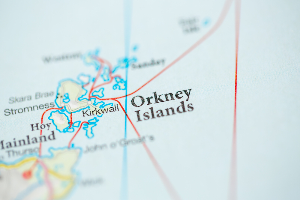
- Biggest Town: Kirkwall (also the capital of Orkney)
- Second Largest Town: Stromness
- Total Area: Around 990 square kilometres (380 square miles)
- Highest Point: Ward Hill on Hoy (481 metres / 1,578 feet)
- Time Zone: Greenwich Mean Time (GMT)
- Currency: Pound sterling (£)
- Language: English is widely spoken; many place names come from Old Norse
- Climate: Mild and windy cool summers and mild winters
- Famous for: Prehistoric sites, Norse heritage, renewable energy, wildlife, and peaceful landscapes
- UNESCO World Heritage Site: The Heart of Neolithic Orkney, includes Skara Brae, Maeshowe, Ring of Brodgar, and Stones of Stenness
- Transport: Connected by ferry and flights; some islands joined by causeways (Churchill Barriers)
- Wildlife: Puffins, seals, otters, seabirds, and whales can be seen
- Economy: Farming, fishing, tourism, and renewable energy
- World's Shortest Flight: Westray to Papa Westray, takes around 90 seconds
History Of Orkney Islands
The Orkney Islandshave a long and rich history that stretches back thousands of years. People have lived here since the Stone Age, and signs of those early communities can still be seen today in the form of stone houses, burial tombs, and standing stones.
Prehistoric Orkney
Orkney is one of the best places in Europe to see remains from prehistoric times. Around 5,000 years ago, people built stone villages and tombs using local sandstone. The most famous examples are:
- Skara Brae- A well-preserved stone village older than the pyramids of Egypt.
- Maeshowe- A large burial tomb aligned with the winter sun.
- Ring of Brodgar and Stones of Stenness- Stone circles likely used for ceremonies or gatherings.
These sites are now part of a UNESCO World Heritage Site known as “The Heart of Neolithic Orkney.”
Iron Age And Picts
After the Neolithic period, Orkney saw the rise of new communities during the Iron Age. People built round towers called brochs and lived in small farming settlements. Later, during the early centuries AD, the Picts lived here. They left behind carved stones and traces of forts, though much of their story is still a mystery.
Norse Rule
In the 8th and 9th centuries, Norse settlers from Norway arrived in Orkney. They became the dominant force on the islands. The Norse language and culture shaped Orkney for hundreds of years. The islands became part of the Norse Earldom of Orkney, and many of today’s place names still come from Old Norse.
Orkney officially became part of the Kingdom of Norway, and later Norway and Denmark together, for over 500 years. The Norse influence remains a big part of Orkney’s identity.
From Norway To Scotland
In 1468, King Christian I of Denmark and Norway gave Orkney and Shetland to Scotland as part of a marriage agreement between his daughter Margaret and King James III of Scotland. The islands were never returned, and they became part of the Scottish Crown.
Even after joining Scotland, Orkney kept many Norse traditions. The local language slowly shifted from Norse to Scots, but the islands held on to their unique mix of cultures.
Orkney In Modern Times
During the 19th and early 20th centuries, farming, fishing, and trade remained the backbone of life in Orkney. The islands were also used for military purposes during the World Wars, especially Scapa Flow, a natural harbor that became a major naval base. After World War II, Orkney grew slowly, with new roads, schools, and better transport links.
In recent decades, the islands have also become known for renewable energy, especially wind and wave power. Tourism, archaeology, and local crafts now support the local economy, along with farming and fishing. Visitors often find that Scottish customs and traditionsare alive and well here, reflected in local festivals, music, and crafts that celebrate the islands' unique heritage.
A Living Heritage
Orkney’s history is not just found in museums or ruins. It lives on through local traditions, stories, and festivals. People in Orkney are proud of their mixed heritage part Scottish, part Norse, and deeply rooted in the land and sea around them.
Geographical Overview Of Orkney Islands
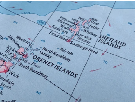
The Orkney Islands are a group of more than 70 islands in northern Scotland. They are located just off the north coast of the Scottish mainland, separated by a body of water called the Pentland Firth. Only about 20 of these islands are lived on, while the others are either small or uninhabited.
Location And Position
Orkney sits at the meeting point of the Atlantic Ocean and the North Sea. This gives the islands a mix of weather patterns and strong sea winds. The islands are part of the Highlands and Islands region of Scotland, and the main island, known simply as “Mainland,” is where most people live. It also holds the largest town, Kirkwall, which is the capital of Orkney.
Island Groups
The islands are often grouped into three main parts:
- Mainland- The largest island and home to most of Orkney’s population, towns, and main roads.
- North Isles- These are the islands north of the Mainland, like Westray, Papa Westray, and Sanday. They are known for birdlife, farming, and peaceful landscapes.
- South Isles- Located to the south of the Mainland, these include islands like Hoy, South Ronaldsay, and Flotta. They are rich in nature, history, and some wartime landmarks.
Size And Shape
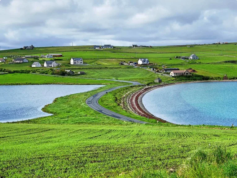
Orkney covers an area of about 990 square kilometers (380 square miles). The islands have a mix of low hills, open farmland, and cliffs. The coastlines are long and often shaped by the sea, with bays, inlets, and sea stacks. Some islands are flat, while others, like Hoy, have hills and steep cliffs.
Land And Nature
The land in Orkney is mostly made up of old sandstone, which has shaped the islands’ gentle curves and soft colors. Much of the land is used for farming, especially for cattle and sheep. Some wide moorlands and wetlands are home to many birds and plants. Because of its location and clean air, Orkney is also a good place to see wildlife. You can spot seals, seabirds, and sometimes even whales off the coast. Visitors to Orkney often enjoy experiencing Scottish culture, which is deeply connected to the land, its farming traditions, and the rich natural surroundings.
Climate And Weather
Orkney has a cool ocean climate. Winters are mild, and summers are cool, with average temperatures ranging from 4°C (39°F) in winter to 15°C (59°F) in summer. Rain and wind are common throughout the year, especially during autumn and winter months. The islands also enjoy long daylight hours in summer and very short days in winter.
Towns And Villages On The Orkney Islands Map
Kirkwall
Kirkwall is the largest town on Orkney and sits on the East Mainland. It is the main center for shopping, dining, and culture on the islands. The town is home to important places like St Magnus Cathedral, a historic church that attracts many visitors. Kirkwall also has the main ferry terminal and the airport, making it the key gateway for travelers arriving or leaving Orkney. You will find plenty of shops, cafes, and services here, making it a convenient base to explore other parts of the islands.
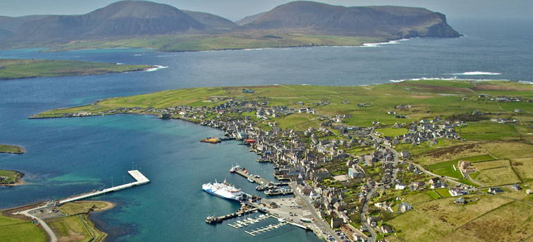
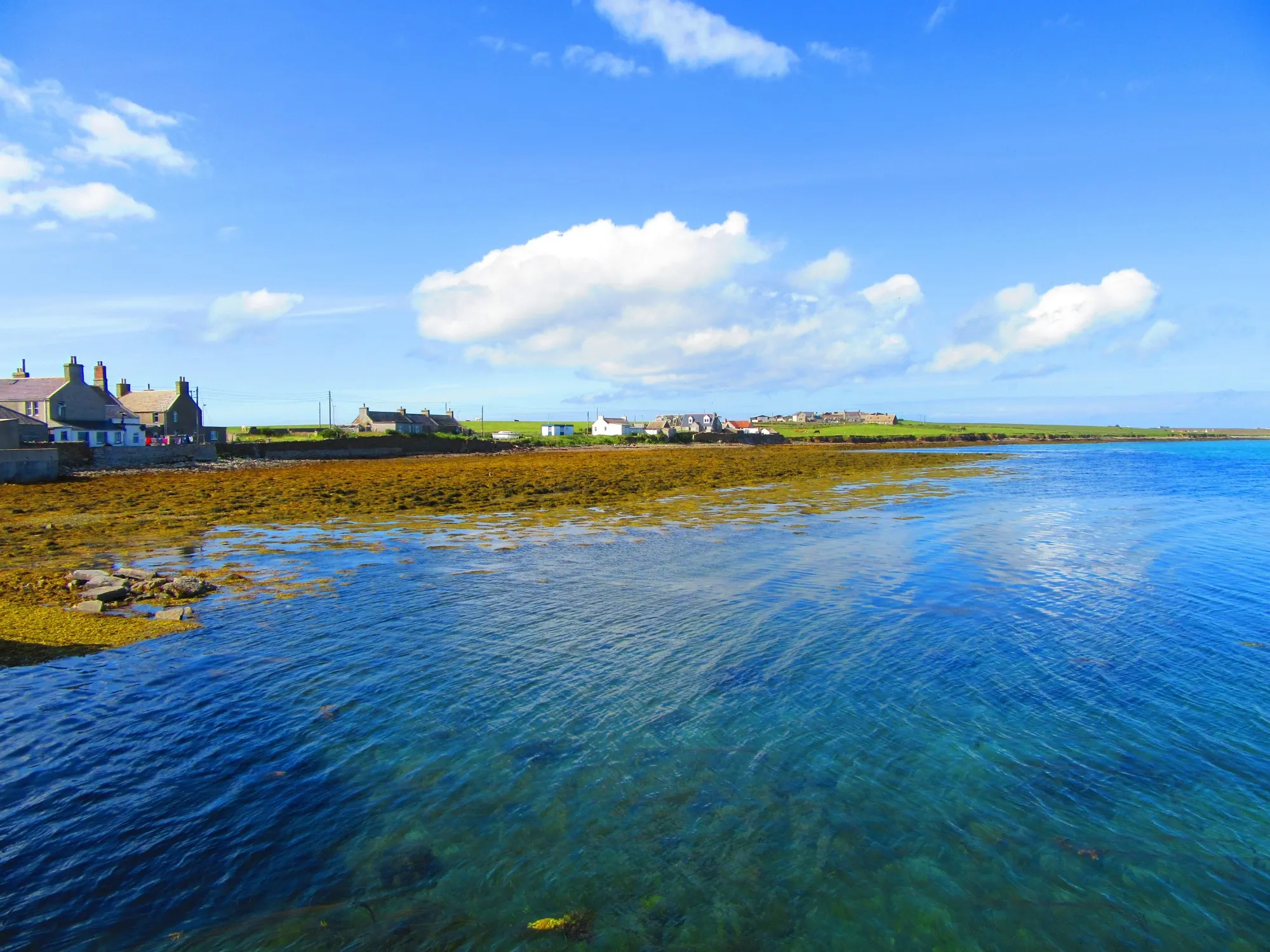
Stromness
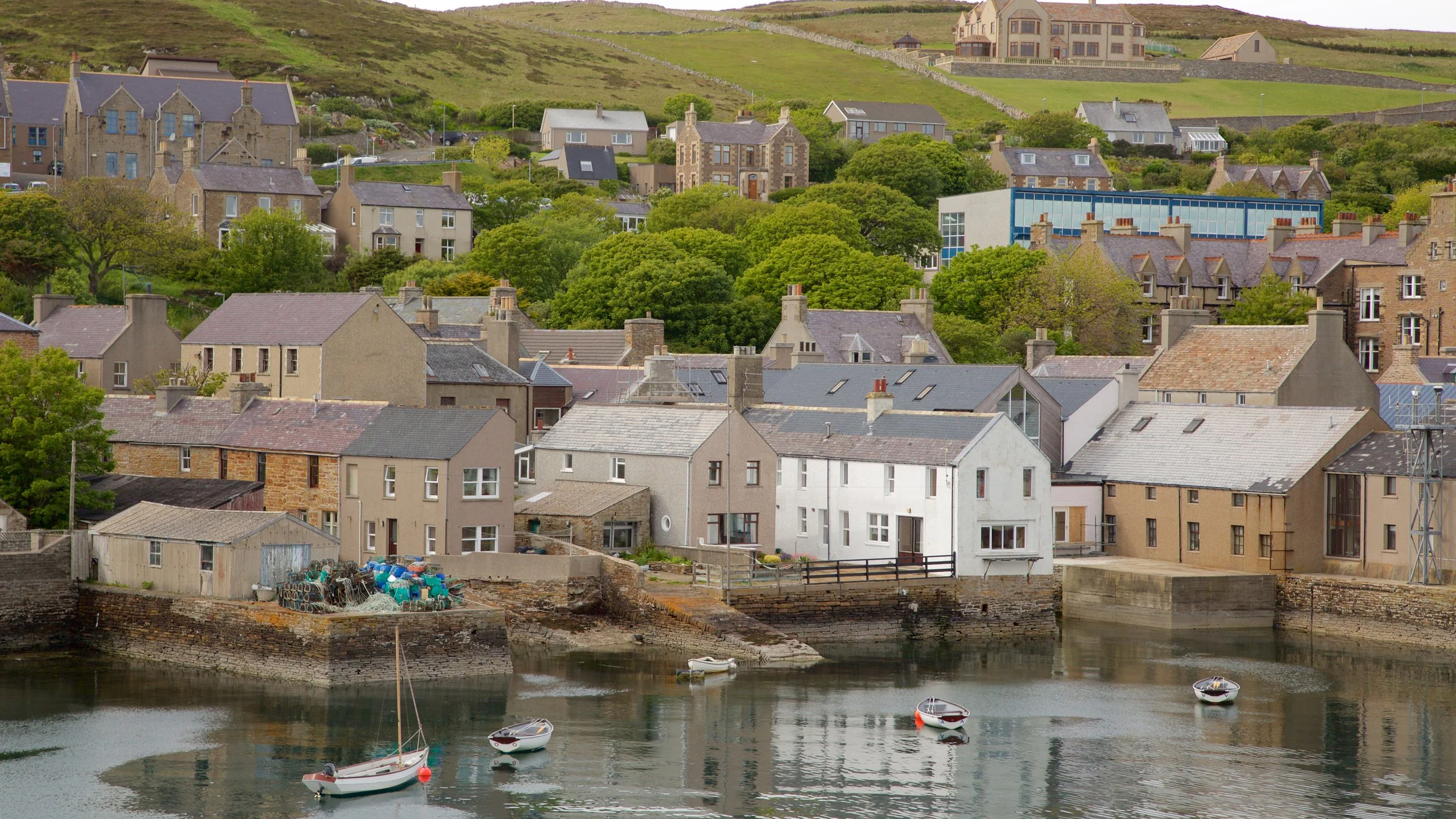
Stromness is the second-largest town and is located on the West Mainland. It is known for its pretty streets and vibrant art scene, with many galleries and small museums. The town has a busy harbor where ferries to other islands leave, making it an important transport hub. Visitors enjoy strolling around Stromness to see its old buildings and enjoy local shops and restaurants.
St Ola And Finstown
Near Kirkwall, the village of St Ola provides residential areas and some local shops, serving as a quieter place close to the main town. Finstown is a small village located between Kirkwall and Stromness. It is a convenient stop for travelers and offers basic shops and services. Both villages are good places to experience local life away from the busier towns.
St Margaret’s Hope
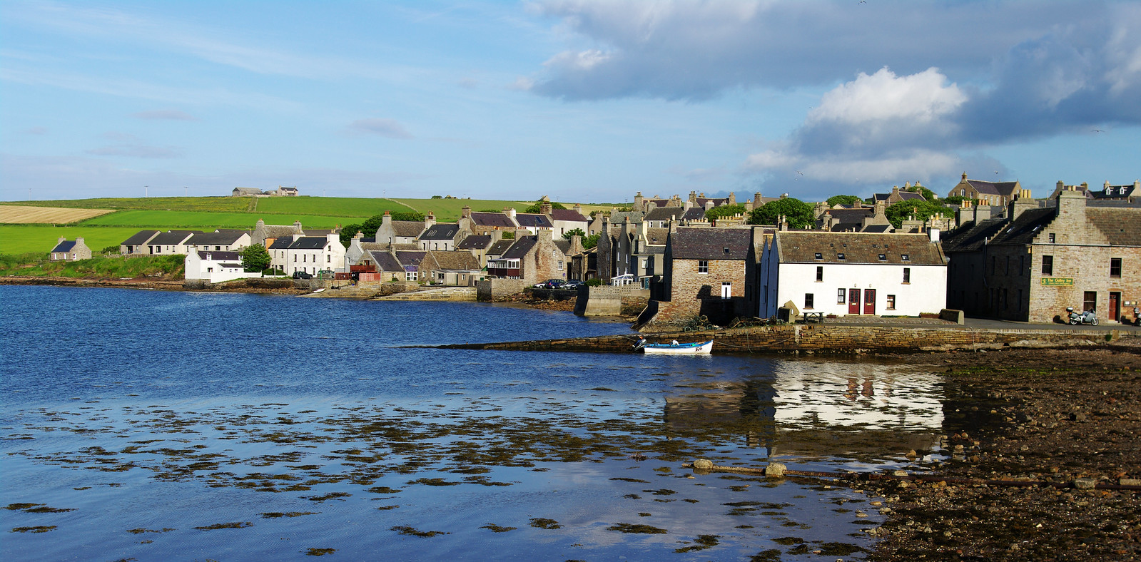
St Margaret’s Hope is the largest village on South Ronaldsay, an island connected to Mainland Orkney by a causeway. This village has a charming harbor and is well known for local festivals and events. It is also where the ferry from Gills Bay on the Scottish mainland arrives. St Margaret’s Hope offers shops, cafes, and places to stay, making it a friendly and welcoming spot for visitors.
Pierowall
Pierowall is the main village on Westray, one of the northern islands. It has essential services like shops, accommodation, and the ferry terminal. The village is a good base for exploring the island’s beautiful coastline and quiet atmosphere. Pierowall is a peaceful place where you can enjoy the slower pace of island life.
Skaill
Skaill is the main settlement on Rousay, often called the “Egypt of the North” because of its many ancient ruins. This village is the ferry point to and from the island and has easy access to archaeological sites nearby. Skaill is small but important for visitors interested in history and nature.
Kettletoft
On the island of Eday, Kettletoft is the village with the ferry terminal. It connects Eday with Mainland Orkney and other nearby islands. The village is quiet and surrounded by farmland, offering a peaceful setting for walkers and nature lovers.
Islands On The Map (And What Makes Each Special)
The Orkney Islands are made up of over 70 islands, but only around 20 have people living on them. Each island has its own charm, with a mix of history, nature, and quiet beauty. Below are 20 of the most important and interesting islands, each offering something different for visitors and locals alike.
1. Mainland Orkney
Mainland is the largest island in Orkney and the centre of most daily life. It is where you’ll find Kirkwall, the capital, with its famous St. Magnus Cathedral, shops, museums, and busy harbour. Stromness, the second-largest town, is also on Mainland and is known for its narrow streets and artistic atmosphere. Mainland has many of Orkney’s most important historic sites, including Skara Brae, a stone-built village older than the pyramids, as well as the Ring of Brodgar and Maeshowe.
2. Hoy
Hoy is one of the most dramatic islands in Orkney, with tall hills, steep sea cliffs, and a wild, rugged feel. It is home to the Old Man of Hoy, a huge sea stack that rises from the ocean and is popular with climbers and photographers. Hoy also played an important role during the world wars, as Scapa Flow nearby was once a major base for the Royal Navy.
3. South Ronaldsay
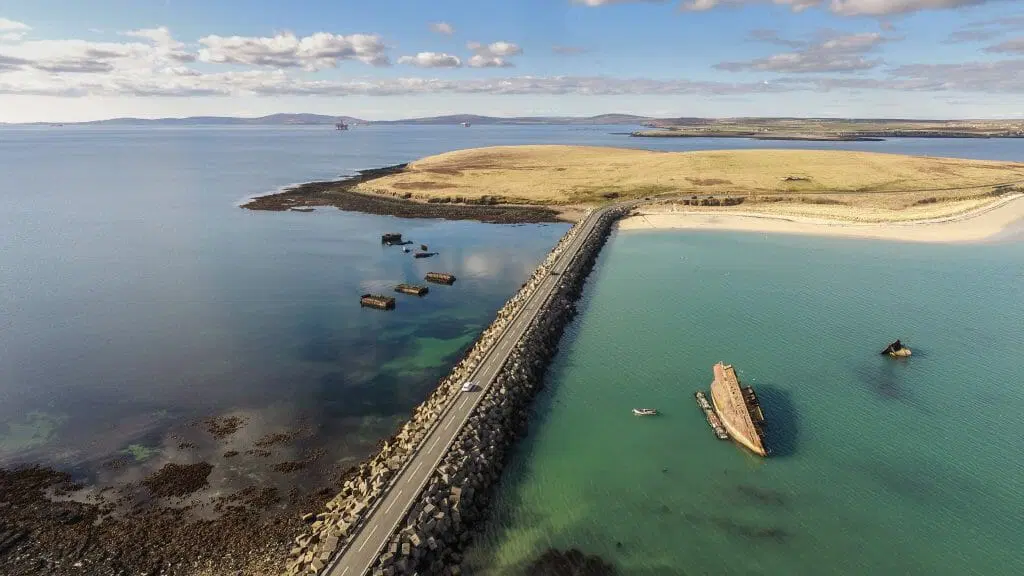
South Ronaldsay is linked to Mainland by the Churchill Barriers, which were built during the Second World War to protect naval ships in Scapa Flow. This island is best known for the Tomb of the Eagles, a Stone Age burial site that lets visitors see ancient bones and artefacts up close. The beaches here are wide and sandy, and the coastline is full of rocky cliffs and gentle waves.
4. Burray
Burray is a small island joined to both South Ronaldsay and Mainland by the Churchill Barriers. It is a quiet, peaceful place that is perfect for those who enjoy nature and simple island life. The island is known for its fossils, which can be found along the shore, and its small museum that tells the story of the island’s past. The coastline is gentle and scenic, with great views of Scapa Flow.
5. Rousay
Rousay is often called “The Egypt of the North” because of the number of ancient sites found here. There are over one hundred archaeological sites on this island, including burial cairns, brochs, and stone houses. One of the most famous is Midhowe Cairn, a large tomb with a roofed walkway for visitors. Rousay is also known for its dramatic coastline, with high cliffs and beautiful sea views.
6. Westray
Westray is a lively island with a strong local community and beautiful coastal views. It is one of the best places in Orkney to see puffins and other seabirds, especially in the spring and summer months. Westray has farms, beaches, craft shops, and historical sites, giving it a good balance of nature and culture. It is also connected to Papa Westray by the world’s shortest scheduled flight, which takes less than two minutes.
7. Papa Westray
Papa Westray, often called “Papay,” is a peaceful and remote island with a long history. It is home to the Knap of Howar, one of the oldest stone houses in Europe that is still standing today. The island is quiet and simple, with just a few homes, farms, and small roads. The landscape is open, and the sea is always close by. Many people visit Papa Westray for its calm feeling, clean air, and deep connection to the past. It’s a place where time seems to slow down.
8. Sanday
Sanday is one of the larger islands and is known for its long, white sand beaches. These beaches are some of the best in Orkney and stretch out for miles. The island is a haven for wildlife, especially seals, otters, and many types of birds. Sanday has gentle landscapes, farmland, and small villages. It is a peaceful island with lots of space, making it popular with people looking to relax and enjoy nature. The name Sanday comes from its sandy shorelines, which are a highlight of any visit.
9. Eday
Eday is a long, narrow island with a strong focus on nature and geology. It is less visited than some of the other islands, so it feels quieter and more untouched. The island is rich in prehistoric remains, such as chambered cairns and standing stones. Its rocks and landscapes are also important for scientists studying Earth’s history. Eday is perfect for travellers who want to walk in peaceful surroundings and learn about the island’s deep past. It offers a more hidden and personal Orkney experience.
10. Shapinsay
Shapinsay is just a short ferry ride from Kirkwall, making it one of the easiest islands to visit. It is known for Balfour Castle, a grand building surrounded by gardens and woodlands. The island itself has rolling green fields, quiet beaches, and birdwatching spots. Shapinsay feels calm and well-kept, with a small community and pretty landscapes. Its closeness to Mainland Orkney means it’s perfect for a day trip or a short visit.
11. Stronsay
Stronsay is one of the larger islands in Orkney, stretching about 10 miles long. Its landscape is a mix of green fields, sandy beaches, and rocky cliffs. The island is famous for its beautiful white sandy beaches, including the popular Bay of Skaill. Farming has been a way of life here for centuries, and the island’s fertile soil supports crops and livestock.
12. North Ronaldsay
North Ronaldsay holds a special place in Orkney’s geography as the most northerly inhabited island. Its most famous feature is the unique North Ronaldsay sheep, which are known for living almost entirely on seaweed along the shore. This unusual diet makes them rare and interesting to farmers and visitors alike. The island itself is windswept and open, with few trees, offering dramatic coastal views of the North Sea.
13. Egilsay
Egilsay is a small and quiet island known mainly for its religious history. It is where Saint Magnus, one of Orkney’s most famous saints, was murdered in 1117. His story is deeply woven into Orkney’s Viking past. The ruins of St. Magnus Church, built in the 12th century, remain a powerful reminder of this history. The island is mainly farmland, with green fields stretching to rugged coastlines.
14. Graemsay
Graemsay is a tiny island located between Mainland and Hoy, with a very small population. It has an almost timeless feel, with few cars and narrow roads that suit bicycles or walking. The island’s land is mostly used for farming, and its fields stretch down to the rocky coastline. Graemsay has strong connections to the sea, and the community relies on fishing and small-scale agriculture.
15. Brough Of Birsay
The Brough of Birsay is a tidal island, meaning it is connected to Mainland Orkney by a causeway that appears only at low tide. It has some of the most important archaeological remains in Orkney, with evidence of Pictish and Norse settlements. The island was once a major religious and trading centre.
16. Copinsay
Copinsay is a small, uninhabited island lying off the east coast of Mainland Orkney. It is a protected nature reserve, managed carefully to support its large seabird populations. Every year, thousands of birds come here to breed, including puffins, kittiwakes, and guillemots. Because of its importance to wildlife, the island is closed to visitors during nesting season to avoid disturbance.
17. Calf Of Eday
The Calf of Eday is a small island just off the northern tip of Eday. It is mostly uninhabited, with rugged coastlines and rocky shores. The island is valued for its natural beauty and wildlife, including seabirds and seals. Its remote location means it is rarely visited, offering a quiet refuge for animals and a peaceful experience for those who do visit. The Calf of Eday is a great place to see Orkney’s wild side, with striking views across the surrounding sea and nearby islands.
18. Fara
Fara lies between Mainland Orkney and South Ronaldsay and is a small island with no permanent residents. It is mostly open grassland and rocky shores, used primarily for sheep grazing. Fara has a quiet and wild feel, surrounded by clear waters and views of larger islands nearby. Its unspoiled landscapes provide good spots for walking, picnicking, and watching wildlife. The island is also part of the natural protection of Scapa Flow, an important naval anchorage with a rich history from both World Wars.
19. Glimps Holm
Glimps Holm is a small island located in Scapa Flow, close to Mainland. It played a key role during World War II as part of the naval defence system. The Churchill Barriers, which connect several islands, were built to protect Scapa Flow’s naval base from enemy submarines, and Glimps Holm was part of this strategic defence. Today, it remains a quiet island, covered in grass and shrubs. Its historical importance attracts those interested in military history.
20. Sweyn Holm
Sweyn Holm is a tiny rocky island off the west coast of Mainland Orkney. It is uninhabited and mostly used as a resting place for seals and nesting seabirds. The island is rugged, with cliffs and rocky shores that provide excellent habitats for wildlife. It is part of Orkney’s rich marine ecosystem and plays a role in supporting local biodiversity. Sweyn Holm is rarely visited by people, making it a natural sanctuary that adds to the overall beauty and wildness of the Orkney Islands group.
Best Places To Visit On The Orkney Islands
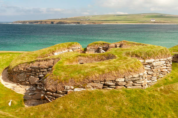
Skara Brae
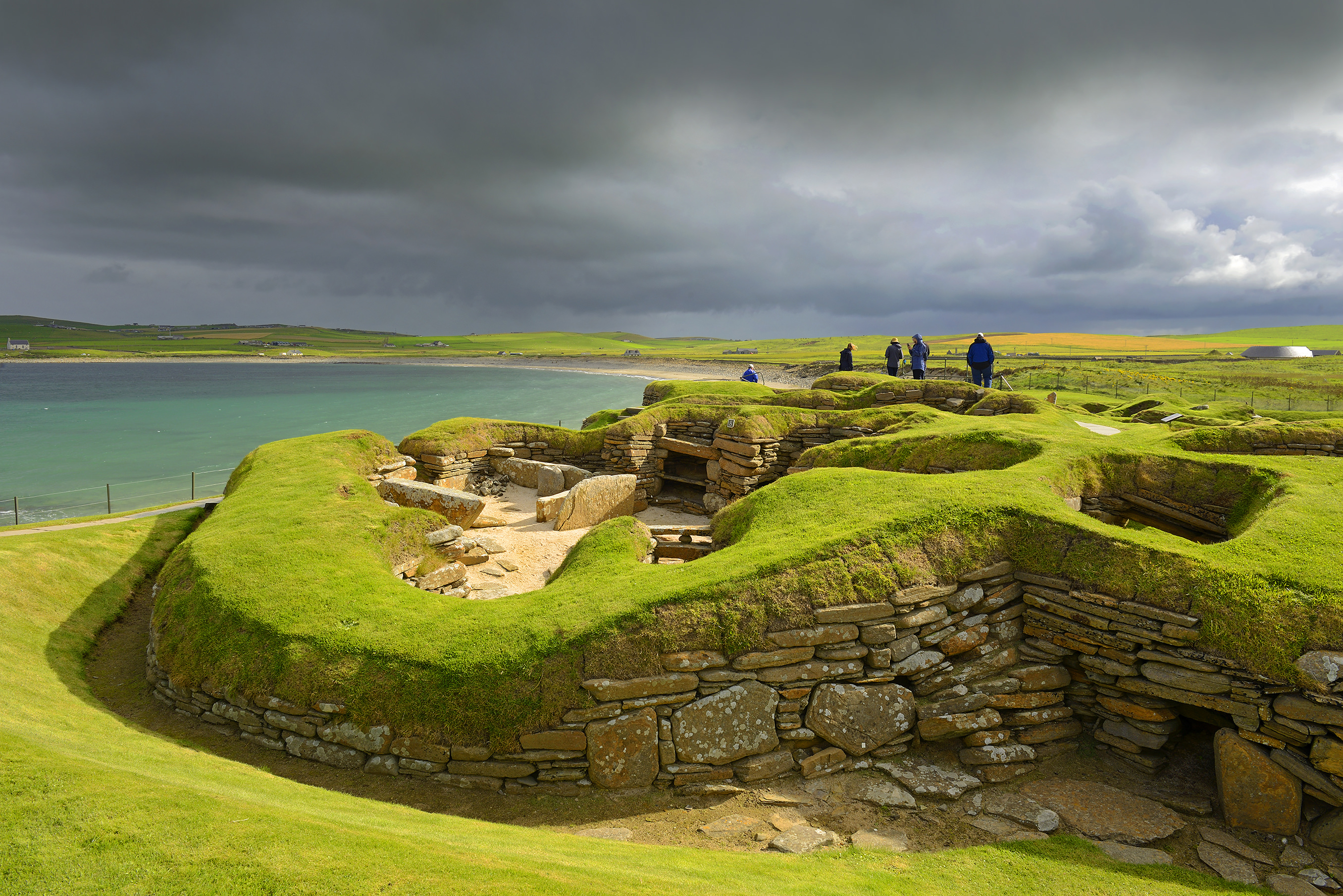
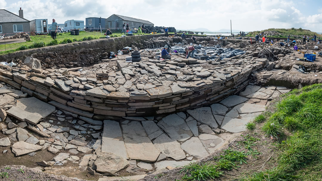
Skara Brae is one of the most important archaeological sites in Europe and a true highlight for anyone interested in ancient history. This Neolithic village is over 5,000 years old and incredibly well preserved. Walking among the stone-built houses, you get a real sense of how people lived during the Stone Age. The site shows how the inhabitants arranged their homes, kept animals, and worked with tools.
Ring Of Brodgar
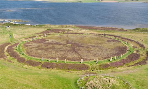
The Ring of Brodgar is a massive stone circle that dates back about 4,500 years, making it older than Stonehenge. It stands in a beautiful natural setting between two small lakes, called lochs, with green hills all around. This site was likely used for ceremonies and gatherings by ancient people, though its exact purpose remains a mystery. The stones are arranged in a perfect circle, and walking around them gives a strong sense of connection to the past.
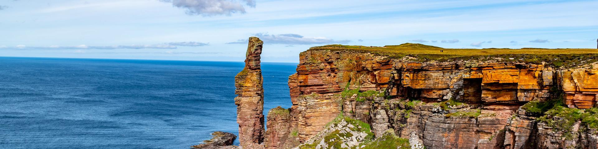
The Old Man Of Hoy
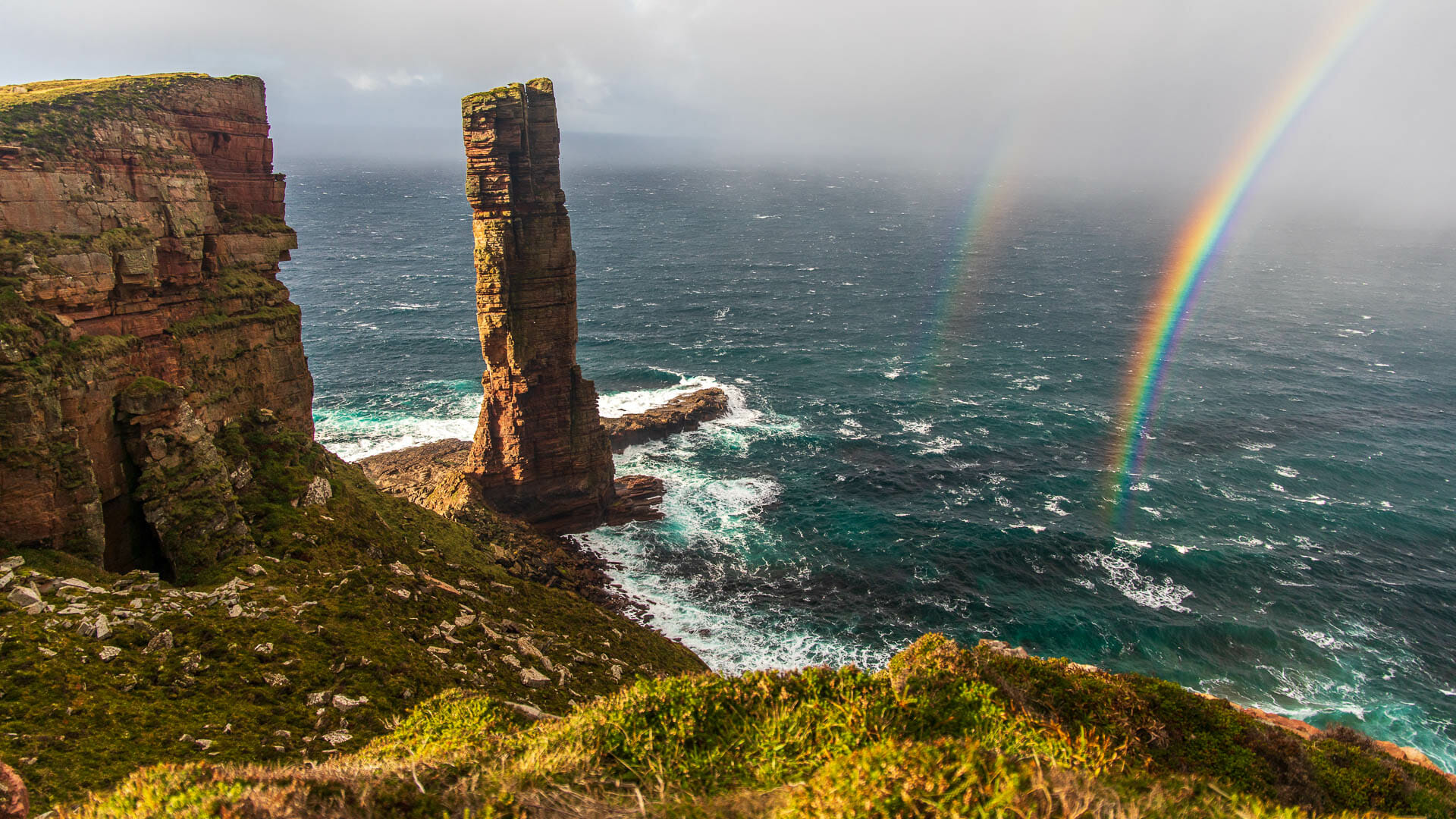
The Old Man of Hoy is a towering sea stack located on the island of Hoy, one of the Orkney Islands. Standing about 137 meters (450 feet) tall, it’s one of the tallest sea stacks in the UK and a dramatic sight against the ocean. The walk to the Old Man of Hoy is popular among hikers and offers spectacular views of rugged cliffs, wild seas, and the surrounding landscape.
Scapa Flow
Scapa Flow is a large natural harbor that has played an important role in both world wars. It was once a major base for the British Royal Navy and was the site of important naval battles and events. Today, Scapa Flow is famous for its underwater wrecks of German warships that sank after World War I, making it a top destination for scuba divers from around the world. On land, the Scapa Flow Visitor Centre offers interactive exhibits explaining the harbor’s military history, the stories of sailors, and the dramatic sinking of the fleet.
Italian Chapel
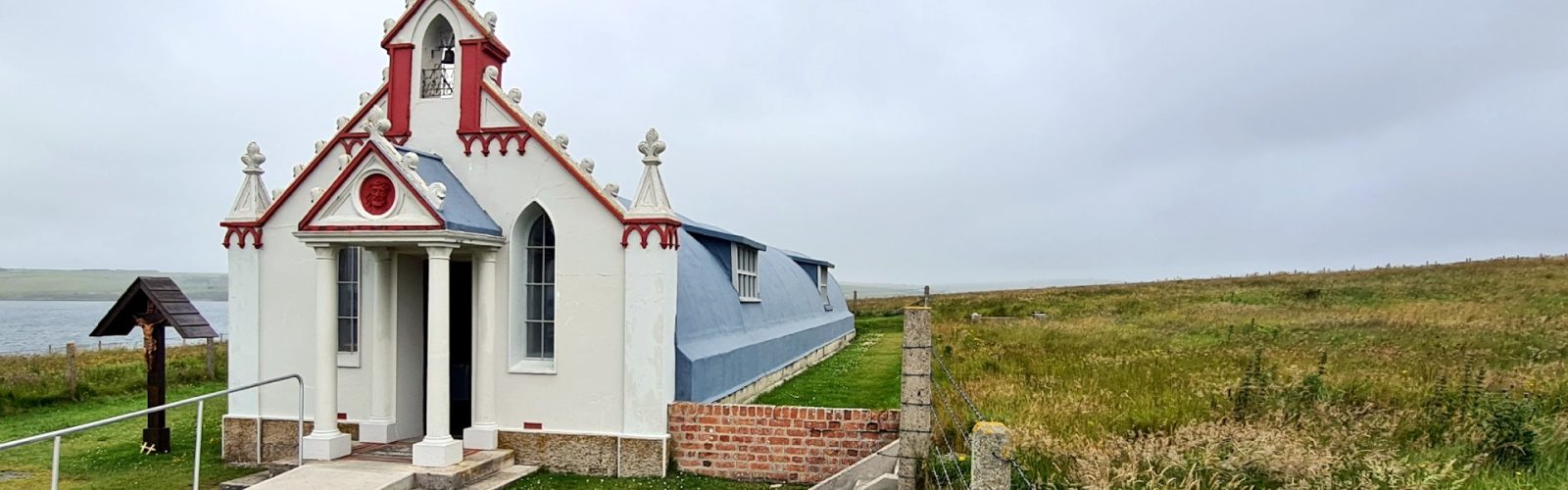
The Italian Chapel on Lamb Holm island is a small, beautifully decorated chapel built during World War II by Italian prisoners of war. These prisoners created the chapel from two old army huts and decorated the inside with detailed paintings, murals, and religious symbols, turning it into a unique work of art and a symbol of hope. The chapel remains a peaceful and moving place to visit, showing how creativity and faith helped people through difficult times.
Yesnaby Cliffs
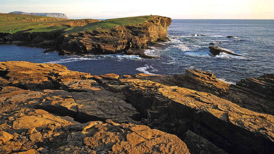
The Yesnaby Cliffs are located on the west coast of Mainland Orkney and offer some of the island’s most dramatic coastal scenery. The cliffs rise steeply from the sea, shaped by thousands of years of wind and waves, creating unique rock formations. Yesnaby is famous for its wildflowers in summer and is a great place to spot seabirds, including puffins.
Maeshowe
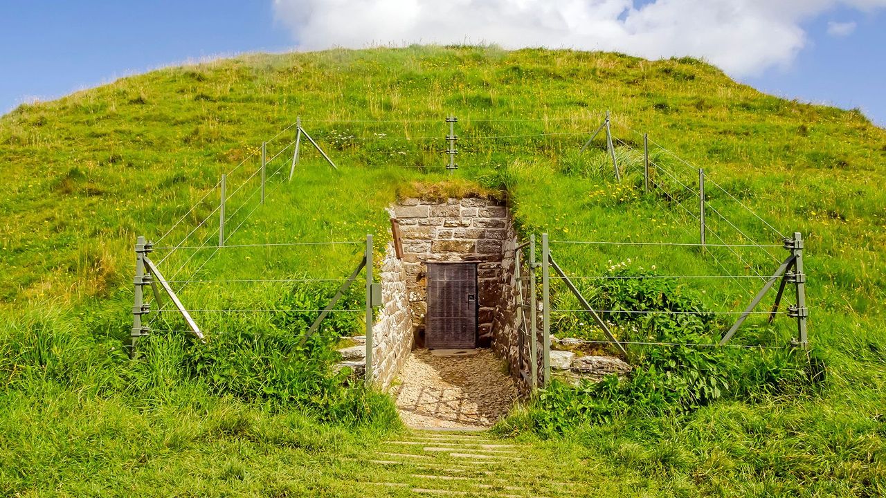
Maeshowe is a large Neolithic burial mound that holds one of the finest examples of chambered tombs in northern Europe. Built over 5,000 years ago, it was used for ritual burials and is famous for the Viking runes carved into its walls during later raids. The tomb is aligned so that sunlight shines into its main chamber during the winter solstice, a remarkable achievement of ancient engineering.
Scapa Flow Museum
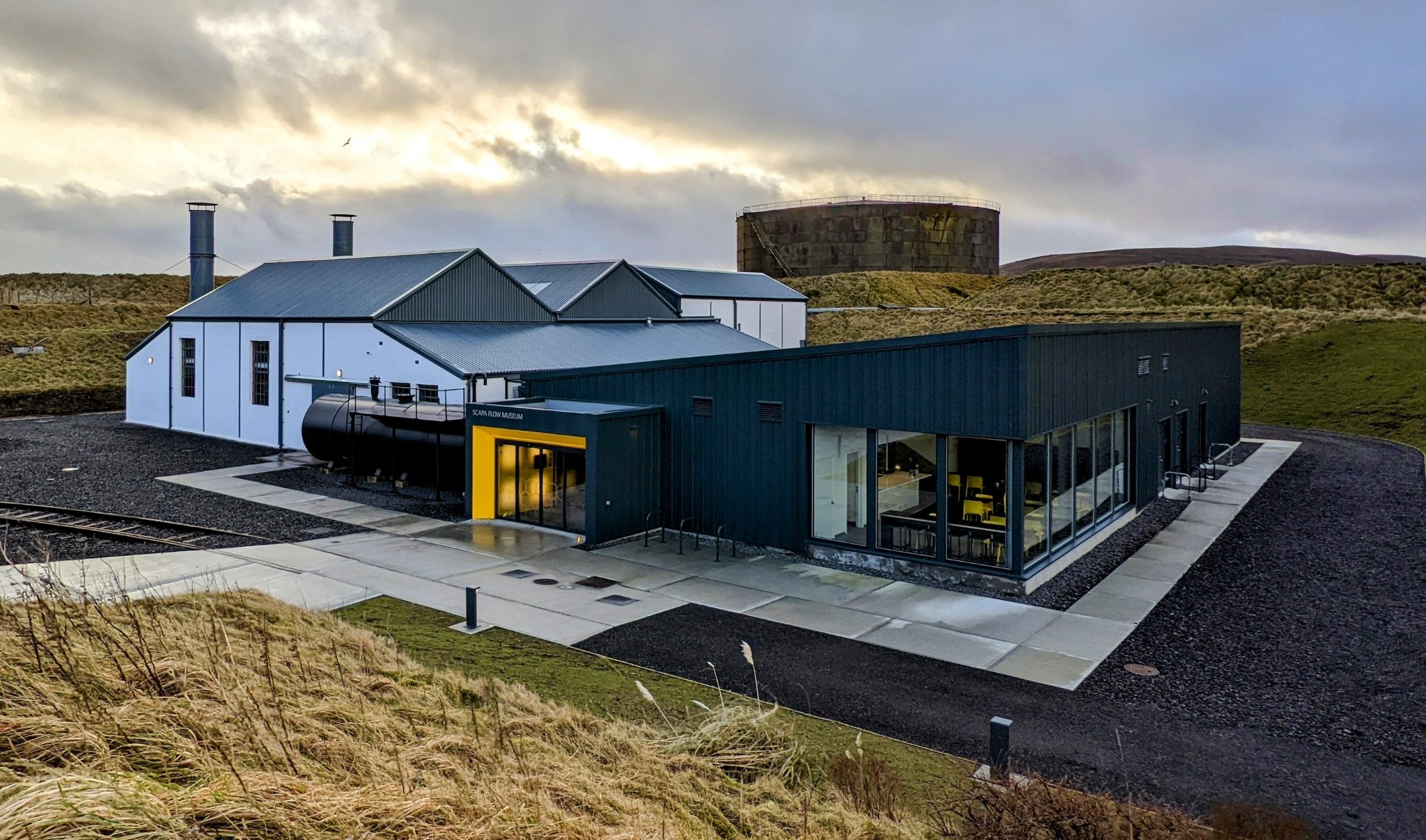
The Scapa Flow Museum is found on the island of Hoy, in the village of Lyness. This museum tells the story of Scapa Flow, one of the most important naval harbors in Britain during both World Wars. You will find models of warships, old photographs, and real-life stories about sailors and the battles fought at sea. The museum also covers the famous scuttling of the German fleet in 1919, when many ships were deliberately sunk in Scapa Flow.
Bu Ness
Bu Ness is a wild and rugged headland on Mainland Orkney, known for its dramatic coastal scenery and striking rock formations. It’s far from busy towns, offering a quiet escape into nature. Walking along Bu Ness gives you beautiful views of cliffs dropping into the sea, waves crashing on rocky shores, and small beaches hidden among the rocks.
Skaill House
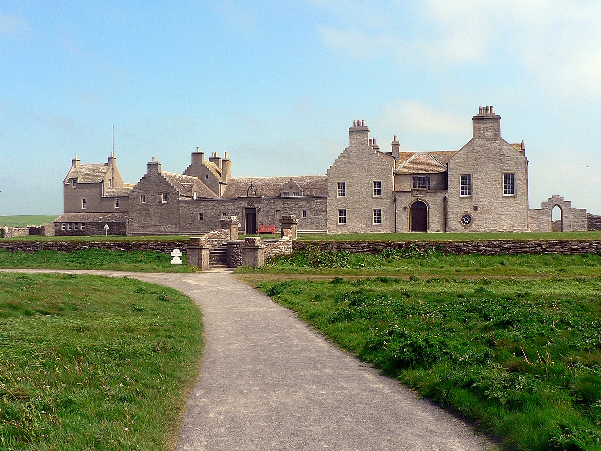
Skaill House is a large, historic mansion located close to the famous Neolithic village of Skara Brae. The house has been home to the same family for centuries and offers a glimpse into the life of wealthy Orkney families from the past. Inside, you can see well-preserved rooms filled with antiques, paintings, and furniture that tell stories of different time periods.
Graemsay
Graemsay is a tiny island located between Mainland Orkney and Hoy. It has a very small population and no cars, which makes it a perfect place to experience quiet island life. The island is covered with green fields, small farms, and walking paths that lead to peaceful spots by the sea. It’s a wonderful place to escape crowds and enjoy nature.
Walking, Hiking, And Wildlife Trails On The Map
St Magnus Way
This is a 55-mile long pilgrimage trail across Mainland Orkney. It passes through small villages, ancient historical sites, and peaceful countryside. It’s perfect for those who want a long walk filled with culture and natural beauty.
Old Man Of Hoy Walk
This coastal trail leads to the famous Old Man of Hoy sea stack. The walk offers stunning views of high cliffs and the sea, making it a favorite spot for nature lovers and photographers.
Rousay Round
A 13-mile circular walk around the island of Rousay. It takes you along dramatic coastlines where you can enjoy sea views and spot wildlife like birds and seals. It’s great for those who want a mix of nature and fresh air.
Marwick Head Cliffs Trail
This trail is inside a protected nature reserve, known for its birdwatching opportunities. Puffins and other sea birds nest here on the cliffs. The trail and maps guide visitors to the best safe spots for watching birds without disturbing them.
Eday Heritage Trail
A quieter trail on the island of Eday, leading through historical sites, peat bogs, and areas with rare plants. This walk offers a nice combination of history and nature on a less crowded island.
Orkney Map Types And How To Use Them
Tourist Maps
Tourist maps are perfect for visitors who are new to Orkney. They show all the important places you might want to visit, like popular attractions, ferry terminals, and places to stay. Towns like Kirkwall and Stromness are clearly marked, making it easy to plan your route. These maps give a simple overview, so you don’t get lost while enjoying the sights.
Topographical Maps
Topographical maps are made for people who love hiking or walking in nature. They show the shape of the land using contour lines, so you can see hills, valleys, and cliffs. These maps also mark paths, forests, farms, and rivers. The Ordnance Survey (OS) Explorer maps are the best for Orkney. Map 463 covers the West Mainland, and Map 464 covers the East Mainland. Together, they give all the details walkers need to explore safely.
Archaeological Maps
Archaeological maps are special maps for people interested in history and ancient sites. Orkney has many old monuments that are protected by Historic Environment Scotland and UNESCO. These maps show where to find places like Skara Brae and the Ring of Brodgar. They help visitors understand the rich history of Orkney and make it easier to visit these important sites.
Digital Navigation Maps
Digital maps are very useful for everyday travel, especially if you have a smartphone or GPS device. Apps like Google Maps or the digital Ordnance Survey maps give real-time directions for driving or walking. They are easy to use but may not work well in very remote parts of Orkney. It’s smart to download offline maps before heading to places with poor signal.
Custom Illustrated Maps
Some local shops offer unique illustrated maps that focus on special topics. These maps might show local wildlife, tell folklore stories, or guide you on artisan craft trails. They are colorful, fun, and give a different view of Orkney. These maps are great souvenirs and add extra meaning to your visit.
Transport Maps And Travel Routes Across Orkney
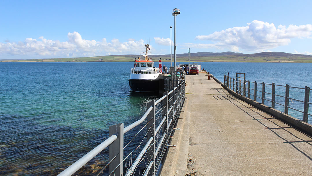
Ferry Routes Across Orkney
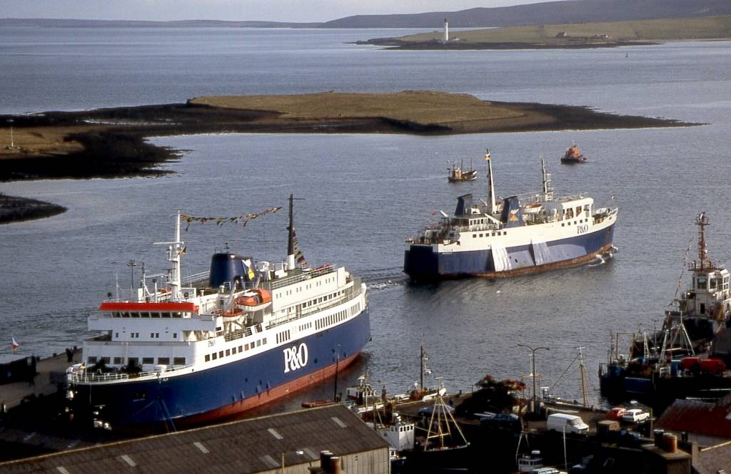
Ferries are the main way to move between the islands and to the Scottish mainland. One of the busiest routes is from Scrabster on the mainland to Stromness on Mainland Orkney. This ferry is run by NorthLink Ferries and is perfect for visitors arriving from mainland Scotland. Another important ferry route is from Gills Bay, also on the mainland, to St Margaret’s Hope on South Ronaldsay. This route is popular because it brings travelers right into the southern part of Orkney.
Air Routes Connecting Orkney Islands
Flying is the fastest way to reach some of the smaller islands. Kirkwall Airport, located on Mainland Orkney, offers short flights to islands such as North Ronaldsay, Westray, and Papa Westray. These flights are quick and use small planes. They offer a great view of the islands from above and help save time when traveling between far-off places.
Bus Routes On Mainland Orkney
On Mainland Orkney, buses connect the main towns and ferry terminals. Bus services run regularly between Kirkwall, Stromness, and smaller villages. The buses are a good option for visitors who don’t want to drive. Transport maps show the bus routes and stops, helping you plan your trips around the island easily.
Driving Routes On Mainland Orkney
If you plan to drive, the main roads to know are the A965 and A964. These roads connect the biggest towns like Kirkwall and Stromness with ferry ports and other important places. The roads are well-maintained and easy to follow. Having a driving map that shows these main roads, along with points of interest, will help you enjoy a smooth trip while seeing the best of Orkney.
Tips For Using Orkney Maps Efficiently
Download Offline Maps Before Your Trip
In many parts of Orkney, especially on smaller islands, phone signals can be weak or missing. Downloading maps to your phone or device before you go means you can still use them even without internet. This helps you stay on track and avoid getting lost in remote areas.
Bring Waterproof Covers For Paper Maps
Orkney’s weather can be rainy, windy, and sometimes misty. Paper maps can easily get wet and damaged from rain or sea spray. Using waterproof covers or plastic sleeves protects your maps, so they stay readable no matter the weather.
Use GPS Devices Carefully And Don’t Rely On Them Alone
GPS on your phone or device is useful for showing your exact location and giving directions. However, it can sometimes be wrong or lose signal, especially in remote places. It’s important to learn how to read traditional maps and use a compass. This skill helps you stay safe if technology fails.
Check Tide Times When Walking Near Beaches Or Coastal Paths
Some footpaths and beaches in Orkney are affected by tides. The sea can rise and block your route, which might force you to turn back or take a longer path. Maps and local signs often show tide times. Checking these helps you plan your walks safely and avoid dangerous situations.
Combine Paper Maps And Digital Maps For The Best Navigation
Using both paper and digital maps together gives you more options and safety. Paper maps don’t rely on batteries or signal, while digital maps can show real-time updates and your exact position. Together, they give you the best chance to navigate Orkney’s islands easily and confidently.
People Also Ask
What Is The Best Time To Visit The Orkney Islands?
The best time to visit Orkney is during late spring to early autumn (May to September). The weather is milder, days are longer, and most attractions and ferry services are fully open.
Does Anyone Live On Orkney Islands?
Orkney is made up of 70 or so islands. Up to 20 may be inhabited depending on the time of year. Some islands are very small and do not have people living there all the time. The estimated total population of Orkney in 2021 was 22,500.
What Are The Benefits Of Living In The Orkney Islands?
Health, safety and services. Very low levels of crime and a strong sense of community help make Orkney a safe and secure environment for all ages. You'll also find we have some of the finest services and facilities in the country.
What Are Orkney People Called?
Orcadians, also known as Orkneymen, are an ethnic group native to the Orkney Islands, who speak an Orcadian dialect of the Scots language, a West Germanic language, and share a common history, culture and ancestry.
How Do I Get Around The Orkney Islands?
You can travel around Orkney by ferry, bus, car, or even bike. Ferries connect the islands, while buses and roads cover Mainland Orkney. For smaller islands, flights from Kirkwall Airport are also available.
Final Thoughts
A detailed map of the Orkney Islands does more than show roads and ferry routes; it helps you see the big picture. Walking through old ruins, enjoying sea views, or planning a peaceful island trip all become easier with a clear map in hand.
With so many islands to visit, each with its own story and charm, using a trusted map makes your time more enjoyable.
Jump to
Quick Facts About Orkney Islands
History Of Orkney Islands
Geographical Overview Of Orkney Islands
Towns And Villages On The Orkney Islands Map
Islands On The Map (And What Makes Each Special)
Best Places To Visit On The Orkney Islands
Walking, Hiking, And Wildlife Trails On The Map
Orkney Map Types And How To Use Them
Transport Maps And Travel Routes Across Orkney
Tips For Using Orkney Maps Efficiently
People Also Ask
Final Thoughts

Callum Fraser
Author
Callum Fraser isn't just a writer about Scotland; he's a product of its rugged landscape and rich history. Born and raised in Perthshire, with the Highlands as his backyard, his love for the nation's stories was kindled by local storytellers and long walks through ancient glens.
This passion led him to pursue a degree in Scottish History from the University of Edinburgh. For over 15 years, Callum has dedicated himself to exploring and documenting his homeland, fusing his academic knowledge with essential, on-the-ground experience gained from charting road trips through the Cairngorms, hiking the misty Cuillins of Skye, and uncovering the secrets of traditional recipes in his family's kitchen.
As the Editor-in-Chief and Lead Author for Scotland's Enchanting Kingdom, Callum's mission is simple: to be your most trusted guide. He combines meticulous research with a storyteller's heart to help you discover the authentic magic of Scotland — from its best-kept travel secrets to its most cherished traditional recipes.
Latest Articles
Popular Articles