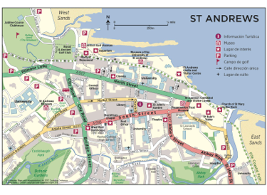
St Andrews Town Map - Key Landmarks And Must-See Places
Don’t miss a thing in St Andrews. This map shows where to go, what to see, and how to get there easily, quickly, and reliably.
Author:Callum FraserJul 03, 202597 Shares48.3K Views
St Andrews is a small town in Scotland, but it’s full of history, beautiful buildings, and famous places like the Old Course and the University. With so much to see in a short space, a good town map can make your visit easier and more enjoyable. It helps you find important spots, plan walking routes, and save time getting around.
Quick Facts About St Andrews Town Map
- Location:St Andrews, Fife, Scotland
- Main Streets:North Street, South Street, Market Street
- Landmarks on the Map:St Andrews Cathedral, Castle, University of St Andrews, Old Course
- Best Way to Explore:On foot using walking routes marked on local maps
- Nearest Beach:West Sands Beach, just a 10-minute walk from the town centre
- Seasonal Maps:Available for graduation week, golf events, and local festivals
- Tourist Info Centre:Located on Market Street, offers free maps and guides
- Offline Access:Maps can be downloaded via apps like Maps.me or Google Maps offline
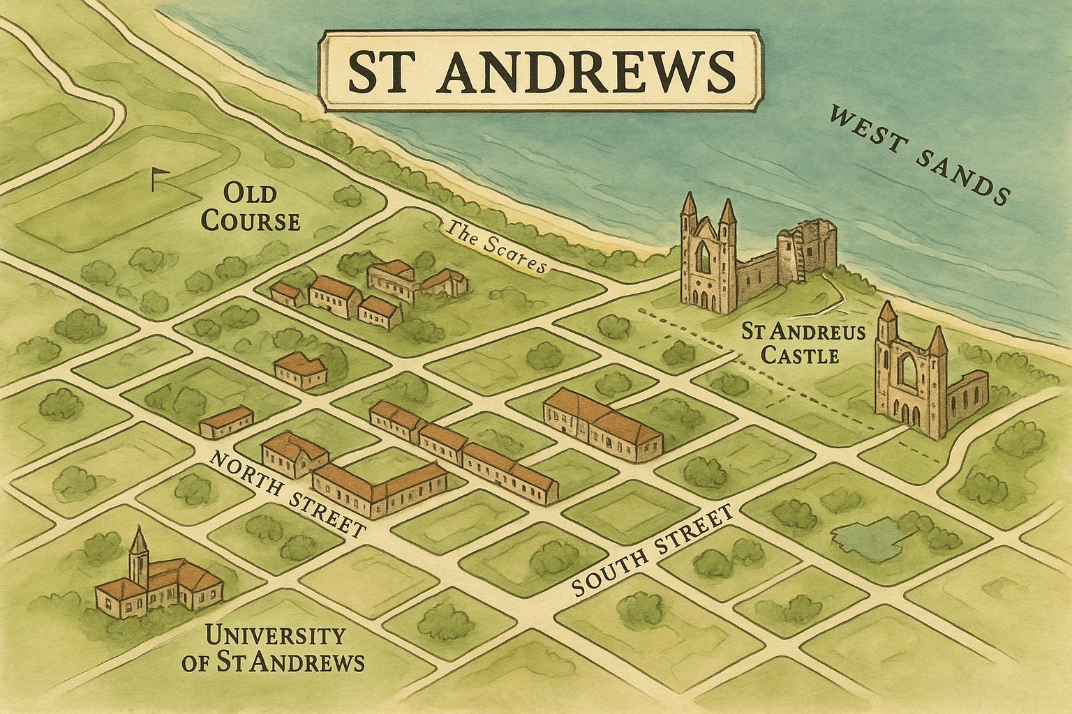
Geographical Overview Of St Andrews
St Andrews follows a layout influenced by both medieval planning and modern tourism needs. Three main parallel streets form the spine of the town: North Street, South Street, and Market Street. These run roughly east to west and host many of the town’s landmarks, shops, and eateries. Connecting lanes, known locally as “wynds” or “closes,” create short, scenic routes between them.
The north of the town faces the North Sea, offering beautiful coastal views, while the southern part houses residential zones and academic buildings. You’ll notice the University of St Andrews buildings scattered across the town, giving the layout a unique blend of civic, educational, and historical zones. At one end of the town sits the Cathedral ruins, while the Old Course golf course dominates the opposite end.
History Of St Andrews Town
St Andrews is one of the oldest towns in Scotland. It has a long history that goes back over a thousand years. The town became important in the Middle Ages because it was home to the largest cathedral in Scotland and a powerful religious center. Many people came to St Andrews for worship, education, and trade.
The University of St Andrews, founded in 1413, is the oldest in Scotland and helped shape the town's growth. Over time, St Andrews also became known around the world as the “Home of Golf,” thanks to its famous Old Course. The town’s history can still be seen today in its old buildings, ruins, and street layout, many of which are shown on local maps.
Main Streets On The St Andrews Town Map
The center of St Andrews has three main streets. These streets are close to each other and make it easy for visitors to walk around and find important places in town.
- North Street:North Street runs along the north side of town, close to the sea. It’s a quiet street with old buildings and beautiful views. Many university buildings are found here, including St Salvator’s Chapel and student halls. If you keep walking, the road leads to St Andrews Cathedraland the Castle ruins. It’s a great street for seeing history and peaceful spots.
- South Street: South Street is one of the oldest streets in St Andrews. It is wide and has many old stone buildings on both sides. Here, you can find churches, museums, gift shops, and places to eat. The Holy Trinity Church, a very old and beautiful church, is also on this street. South Street feels calm and historic, and it connects to smaller paths that lead to other parts of town.
- Market Street:Market Street sits between North Street and South Street. It is the busiest of the three. This street is full of life, with cafés, small shops, restaurants, and local stores. It’s a good place to grab food, buy souvenirs, or just enjoy the local vibe. Market Street is popular with both tourists and students, and many walking tours pass through it.
Key Landmarks On St Andrews Town Map
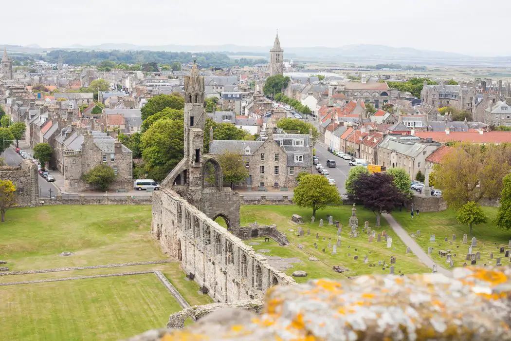
St Andrews Cathedral
St Andrews Cathedral is one of the most famous places in the town. Long ago, it was the largest church in Scotland. Today, it stands as a beautiful ruin by the sea. You can still see the tall stone towers, old graveyard, and broken walls. The site feels peaceful and powerful, reminding visitors of the town’s religious past. There’s also a small museum with items found during excavations. You can climb St Rule’s Tower nearby for amazing views of the town and sea.
St Andrews Castle
St Andrews Castle sits on a cliff above the beach and has a long history. It was once home to powerful bishops and later used during battles and religious struggles. Visitors can walk through the ruins, explore the bottle dungeon (a deep prison cell), and even go down into a narrow underground tunnel used during a siege. The castle offers great views of the sea and is a fun place to learn about Scotland’s medieval past.
University Of St Andrews
This university is the oldest in Scotland, started in 1413. It’s known around the world for its history and famous students, including Prince William. The university buildings are spread around the town. Key spots include St Salvator’s Quad, which has a beautiful chapel and courtyard, and the King James Library, which is still used by students. Maps often show university sites clearly so visitors can follow a self-guided walking route.
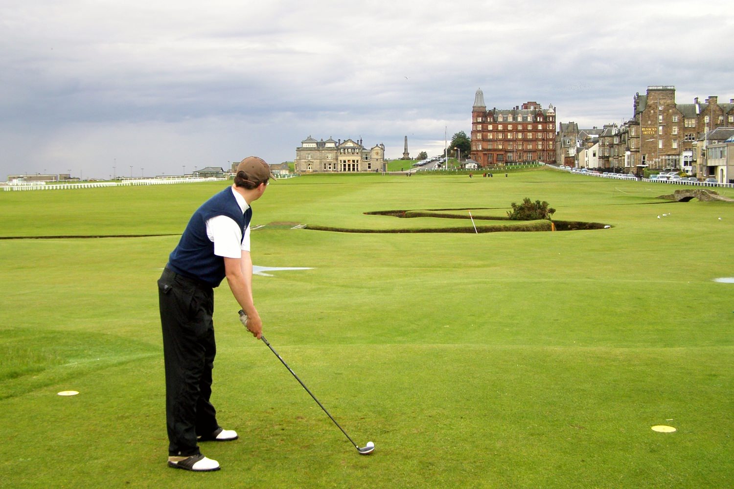
The Old Course
The Old Course is one of the most famous golf courses in the world. People call it the “Home of Golf” because the game has been played there for hundreds of years. Even if you don’t play golf, it’s worth seeing the 18th hole, the Swilcan Bridge, and the Royal and Ancient Golf Club building. Many tourists walk the public path beside the course to take photos and enjoy the wide-open views.
The Scores
The Scores is a quiet road that runs along the top of the cliffs, next to the sea. Walking along The Scores gives you lovely views of the coastline and many historic buildings. You’ll pass university buildings, gardens, and stone houses. This road connects the Cathedral and Castle with the golf course area, making it a great scenic route for visitors.
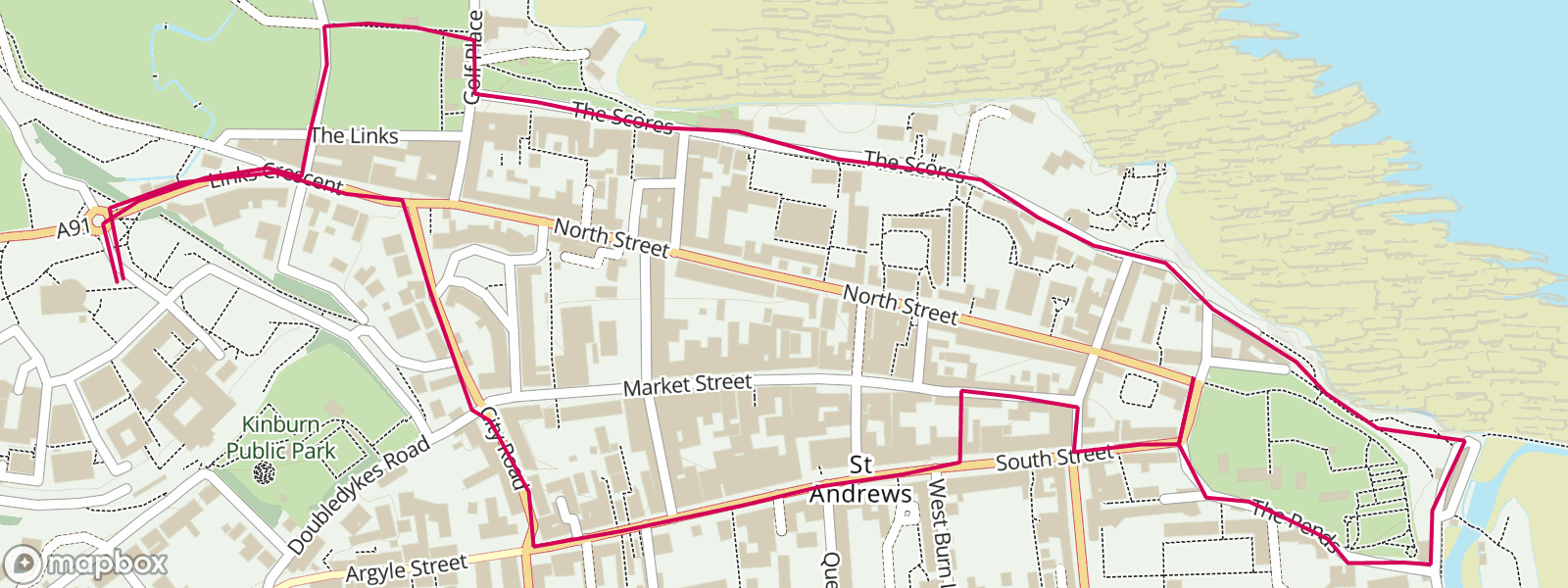
Popular Walking Routes On St Andrews Town Map
St Andrews is a great town to explore on foot. Many walking routes are marked on town maps to help visitors enjoy different parts of the town. These walks show you the best places to see and give you a good feel for the history, nature, and local life.
The Historical Trail
This walk starts at St Andrews Cathedral, goes past St Andrews Castle, through the University of St Andrews, and ends at Market Street. It shows you some of the oldest and most important parts of the town. You’ll walk on old stone paths and see historic buildings along the way.
Coastal Path Walk
This is part of the larger Fife Coastal Path. It follows the edge of the sea and gives you amazing views of the cliffs and waves. The path passes golf courses, rocky beaches, and quiet natural spots. It’s a peaceful route for people who enjoy nature and sea views.
Academic Tour
This walking route takes you around the main university buildings. You’ll see student halls, lecture halls, libraries, and the famous St Salvator’s Quad. The walk gives a good idea of student life and shows how the university is a big part of the town.
Golf Heritage Walk
This walk is perfect for anyone who loves golf. It starts at the British Golf Museum, continues to the Old Course, and includes the Swilcan Bridge and 18th green. You don’t have to be a golfer to enjoy the sights. Many people walk this path just to see where golf history was made.
Photography Loop
This walking route is made for people who enjoy taking pictures. It includes early morning shots at West Sands Beach, photos of the tall towers at the Cathedral, and colorful street scenes around Market Street. It’s a mix of old buildings, natural views, and busy town life.
These walking routes are easy to follow and are shown clearly on free maps. You can find them at the visitor center, local shops, or hotels around town.
Town Centre Hotspots You’ll Find On The Map
The centre of St Andrews is full of interesting places to visit. Most of these are found along Market Street and South Street. Town maps often highlight these spots so visitors can find them easily.
Janetta’s Gelateria
This is a popular ice cream shop loved by locals and visitors. It has won many awards for its tasty and unique flavours. It’s often marked on tourist maps as a must-visit for anyone who enjoys sweet treats.
Forgan’s St Andrews
Forgan’s is a stylish restaurant found down a small alley off Market Street. It serves Scottish food and often hosts live music or small events. Maps sometimes show it with a food or entertainment symbol.
St Andrews Museum
This museum is a quiet place that tells the story of the town’s history. It’s not as well known as other sites, but it’s worth a visit. The museum has old photos, objects, and displays about life in St Andrews.
Town Hall
The Town Hall is an important building in the middle of town. It is used for community meetings and special events. On most maps, it’s shown near Market Street and marked as a public building.
Public Amenities
Town maps also show useful places like:
- Public toilets
- Free Wi-Fi zones
- First aid and emergency points
- Tourist information spots
These are helpful for visitors and easy to find when using a local map.
Types Of Maps Of St Andrews
Different types of maps can help visitors enjoy and understand St Andrews in different ways. Some maps show landmarks, while others focus on walking paths, golf areas, or university buildings.
Tourist Maps
These are the most common maps for visitors. They show:
- Landmarks like the Cathedral and Castle
- Main streets (North, South, and Market Street)
- Shops, restaurants, and hotels
- Walking routes and photo spots
You can get them at the visitor centre, hotels, or online.
Walking Route Maps
These maps are made for people who want to explore on foot. They include:
- Easy-to-follow walking paths
- Step-by-step routes with distances
- Points of interest along the way
- Coastal trails and scenic spots
They’re great for planning short or long walks around town.
Golf Course Maps
These maps focus on the golf areas of St Andrews. They show:
- The layout of each hole on the Old Course
- Clubhouses and practice areas
- Nearby paths and public viewing spots
Golf fans often use these maps to learn more about the famous courses.
University Maps
The University of St Andrews offers its own maps that highlight:
- Lecture halls and classrooms
- Libraries, chapels, and dorms
- Student services and visitor buildings
These are helpful for students, new visitors, and those on academic tours.
Digital Maps
Many visitors use digital maps on their phones. These maps:
- Use GPS to show your current location
- Let you search for places quickly
- Can be downloaded for offline use
- Often include real-time directions and reviews
Apps like Google Maps, Maps.me, and AllTrails are popular in St Andrews.
Residential Areas And Local Neighborhoods In St Andrews
St Andrews is not just for visitors. It’s also home to students, families, and local residents. A good town map helps you understand the different areas people live in. Some neighborhoods are busy with tourists, while others are calm and more private.
East End
This part of town is known for the Cathedral and Castle. It has a quiet feel and lots of history. Many old stone buildings are here, and the streets are peaceful. It’s a great place for a relaxing walk or a quiet stay.
West End
The West End is busier. It’s close to the Old Course and West Sands Beach, so more tourists spend time here. You’ll find hotels, restaurants, and golf shops. The area has energy and a strong connection to the town’s golf history.
Kinnessburn Area
This is a calm, mostly residential part of town. It’s not far from the town center but feels more peaceful. Many students live here, so you’ll find a mix of student flats and houses. It's a good area for longer stays or local walks.
Lawhead Road And Strathkinness Low Road
These roads are in quieter parts of town with local homes and fewer tourists. Town maps often show walking loops around these streets for people who want to see the local side of St Andrews. These areas feel more like regular Scottish neighborhoods.
Student Housing Zones
Maps often mark where student residences are located. This helps visitors understand which parts of town are busier during the school year and which are quieter during holidays. It also helps parents, students, and university staff find key buildings quickly.
Public Transport And Parking Spots On The St Andrews Map
St Andrews does not have a train station, but getting around is still simple. Town maps show key transport locations, car parks, and other helpful traveldetails. This helps visitors plan their routes easily.
Bus Stations
- The main bus stop is on Largo Road.
- Buses run to and from cities like Dundee, Edinburgh, and Glasgow.
- Maps show the bus stop clearly, often with nearby shelter or timetable symbols.
Taxi Ranks
- Town maps mark taxi ranks at busy points like Bell Street and near the Golf Museum.
- These are good spots to catch a taxi quickly, especially during busy tourist seasons.
Car Parks
Maps highlight car parks with parking symbols. Some of the main ones include:
- Petheram Bridge Car Park- Closest to the town centre.
- Argyle Street Car Park- Best for long-stay parking.
- Bruce Embankment Car Park- Ideal for beach visits and the Old Course.
Disabled Parking Zones
- Most up-to-date maps highlight disabled parking areas.
- These are near key sites and make access easier for everyone.
Electric Vehicle Charging Points
- More EV charging stations are appearing on newer maps.
- These are marked with clear electric plug icons, often found in larger car parks.
Extra Navigation Info
Many printed and digital maps also show:
- Traffic restrictions during busy periods
- Pedestrian-only zones around shopping streets and historic sites
- Seasonal changes, such as road closures during golf events or festivals
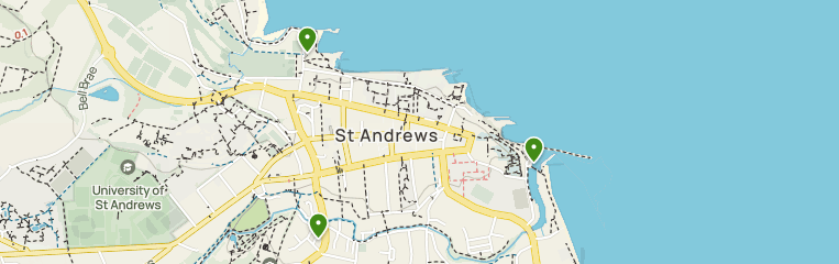
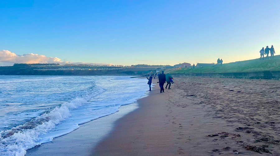
Top Beaches And Sea Views In St Andrews
West Sands Beach
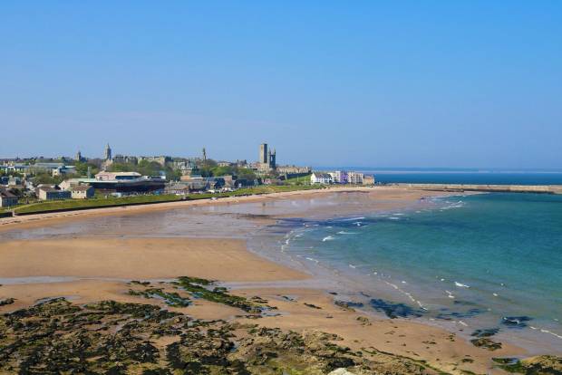
West Sands is the most famous beach in St Andrews. It stretches for nearly two miles and runs alongside the Old Course. It’s known for its wide, flat sand and was made famous by the film Chariots of Fire. Most town maps clearly mark the main access near the Old Course clubhouse and Bruce Embankment Car Park. You'll also find nearby restrooms, a walking path, and great views of the sea and golfers.
East Sands Beach
Located on the other side of town near the Cathedral ruins, East Sands is a smaller but more sheltered beach. It’s popular with families, dog walkers, and sea swimmers. Maps show the main entrance near the East Sands Leisure Centre. The area also includes a small harbour, picnic spots, and walking paths that connect to the coastal trail leading south.
Castle Sands
This beach sits just below the ruins of St Andrews Castle. It’s small, rocky, and more hidden than the others. It’s usually marked on more detailed town maps or coastal walking guides. There’s a narrow path leading down from The Scores, but access can be tricky, especially in bad weather. It’s a quiet spot with dramatic views, best for those who enjoy peaceful, less crowded places.
Golf-Centric Mapping
Golf is a big part of life in St Andrews. The town is known around the world as the “Home of Golf,” and its golf courses are a major attraction. Town and course maps show golf areas in great detail, helping visitors, fans, and players find their way around and enjoy the experience.
- The Old Course:The Old Course is the most famous golf course in St Andrews. It has 18 holes and is one of the oldest in the world. On most maps, you’ll see the full layout of the course, including well-known features like the Swilcan Bridge and the Road Hole bunker.
- Other Courses:St Andrews has more than just the Old Course. Nearby, there are several other golf courses, and many local maps show all of them clearly. These include the New Course, Jubilee Course, Eden Course, Strathtyrum Course, and the Balgove Course.
- Golf Academy: The St Andrews Links Golf Academy is located just southeast of the Old Course Hotel. It is a modern training centre where golfers can practice, get lessons, and use high-tech equipment to improve their skills.: Clubhouses And Golf Facilities
- Golf Shops And Museums: Near the 1st and 18th holes, you’ll find golf-related places like pro shops and the British Golf Museum. These locations are often shown on maps to help visitors plan their visit.
Food, Drink, And Market Stops On The Map
Maps of St Andrews often show where to find good food, coffee, and local markets. These places are usually marked with small icons like cups, forks, or shopping baskets. This helps visitors plan where to stop for a meal or snack while exploring the town.
Bell Street And Market Street
These two streets are full of places to eat. You’ll find many cafés, bakeries, and takeaway spots close together. It’s a good area for a quick bite, coffee, or a sweet treat. This part of town is always busy and full of energy.
South Street
South Street has more fine dining options. You’ll find restaurants with Scottish dishes, wine bars, and stylish coffee shops. It’s a quieter area for those looking for a relaxed lunch or dinner in a nice setting.
Fife Farmers Market
This local market takes place on the first Saturday of each month at Argyle Street car park. Vendors sell fresh produce, handmade goods, and hot food. It’s often shown on maps with a market icon, especially on event days.
Northpoint Café
This café is famous for its sign that says: “Kate met Wills here.” It’s a popular photo stop for visitors and a nice place to grab a coffee or breakfast. It’s usually marked on town maps because of its fun royal connection.
Balgove Larder
Located just outside the main town, Balgove Larder is a farm shop with fresh food, a café, and a steak barn. It’s often shown on larger or regional maps and is a popular stop for both locals and tourists looking for fresh, local meals.
Little Italy
A well-loved Italian restaurant located near South Street. It’s known for fresh pasta, friendly service, and romantic evening dinners. This spot is often highlighted on food maps or mentioned in local food guides.
The Seafood Ristorante
Located by the sea, near the Old Course and West Sands Beach. It offers fresh seafood with stunning views of the water. It’s usually marked on more detailed maps, especially those that include fine dining.
Jahangir Tandoori
A popular Indian restaurant offering classic curries and warm hospitality. It’s located just off South Street and is a favourite among locals and students. Often included on food-focused maps or takeaway guides.
The Tailend
Famous for its award-winning fish and chips. Found on Market Street, it’s easy to spot on walking maps and food tours. Many people stop here after a day of sightseeing.
Mitchell’s Deli
A cosy spot serving brunch, soups, and sandwiches. Located on Market Street, it’s also a deli with local produce. It’s typically marked on maps aimed at café lovers or brunch spots.
Taste Café
A student-favourite coffee shop located just off North Street. It’s known for its flat whites, homemade cakes, and relaxed vibe. It may appear on town maps near university buildings or as part of walking trails.
The Cottage Kitchen
A charming café tucked into a side street near the town centre. It serves homemade meals and baked goods. Its hidden feel makes it a favourite on “hidden gems” or local foodie maps.
St Andrews Brewing Company
Great for local craft beer and pub food. The brewery has a bar on South Street and another near the golf course. Town maps with pub trails or beer tours usually mark this stop.
The Adamson
A modern restaurant and cocktail bar on South Street. Known for its stylish interior and creative food, it’s often highlighted on premium dining maps and guides.
Seasonal And Festival Map Layers
Some events in St Andrews bring in large crowds. During these times, the town uses special map versions or adds extra layers to help people find their way. These seasonal maps are often available in print or online and show temporary changes like road closures, event zones, or extra services.
Graduation Week
- Procession routes through the town
- Special venues for ceremonies and photos
- Parking restrictions near busy areas
These maps help families, students, and visitors move around smoothly during the celebrations.
Golf Open Tournaments
When St Andrews hosts major golf events like The Open, the maps change to guide large crowds. These seasonal maps highlight:
- Paths for spectators
- Extra first aid points and restrooms
- Overflow parking outside the town centre
- Shuttle stops and restricted access zones
They make it easier for both fans and locals to get around safely during big tournaments.
Christmas Market And St Andrews Day
In late November and December, the town becomes festive with lights, stalls, and events. Special maps for this season show:
- Event sites in Church Square and along South Street
- Street closures or limited vehicle access
- Locations of food stalls, music stages, and holiday displays
These maps are useful for families, shoppers, and anyone visiting during the holidays.
Freshers Week
At the start of the academic year, Freshers Week welcomes new students. Student maps during this time include:
- Dormitory and accommodation locations
- Event venues for student activities
- Suggested walking routes between campus sites
- Pub crawl paths and safety zones
These maps help students find their way and enjoy events safely during their first week in town.
Where To Find These Maps
Tourist offices, the university, and event websites often provide these seasonal maps:
- Some are printable PDFs
- Others are digital and can be viewed on phones
- Maps may include QR codes posted around town for quick access
Seasonal map layers make it easier to navigate St Andrews during busy times of the year and help both locals and visitors enjoy events with less stress.
How To Read And Use A St Andrews Town Map Effectively
Look For The Legend
The legend, sometimes called the map key, is where all the symbols on the map are explained. These small icons represent places like public toilets, cafés, museums, and parking zones. Taking a moment to understand the legend will help you read the map more easily and avoid confusion while exploring.
Use A Highlighter For Printed Maps
If you’re using a paper map, it helps to bring a pen or highlighter. You can mark your walking route, circle your hotel, or highlight spots you don’t want to miss. This makes it easier to follow your plan and keeps your path clear without having to stop and figure it out repeatedly.
Understand The Map Scale
Every map has a scale that shows how distance on the map compares to real life. For example, one centimetre on the map might equal one hundred metres on the ground. Knowing this helps you figure out how far you’ll be walking, so you don’t underestimate the time or distance between places.
Take A Screenshot Of Digital Maps
If you’re using your phone for navigation, it’s a smart idea to take a screenshot of the map area you need before you head out. This way, if you lose internet connection or GPS signal, you’ll still have the map on your phone. It can save time and keep you from getting lost.
Try The Accordion Fold
Big paper maps can be awkward to carry around. Folding your map in an accordion style (like a fan) helps you keep just the section you need visible. It saves time, keeps your hands free, and lets you check your location quickly without opening the entire map each time.
Maps Help You See The Bigger Picture
Using a map is not just about getting from one place to another. A good town map helps you understand how different parts of St Andrews are connected. You’ll start to see how the university buildings, cathedral, castle, and golf course all fit together. This deeper understanding makes your walk more meaningful and your visit more enjoyable.
People Also Ask
Is St Andrews A Village Or Town?
St Andrews is a small town, and while much safer when compared to larger cities, you will still need to exercise common sense with regard to your personal physical and social safety. The University funds a night bus which helps get you home safely seven nights a week from 10 pm until 2 am.
How Big Is St Andrews Town Centre And Can I Walk Everywhere?
St Andrews town centre is small and walkable. Most landmarks are within a 10–15 minute walk, making it easy to see everything on foot without needing a car.
What’s The Best Walking Route To See St Andrews’ Main Attractions In One Day?
Start at West Port, walk through South Street to the University, then head to the Castle, Cathedral, and finish at the Old Course and beach. The loop takes 2–3 hours at a relaxed pace.
Does It Snow In St Andrews?
Fortunately when the snow sticks it usually melts off within a day, so you do not have to go very long without being able to play a round. Being able to play golf year round in St Andrews, minus those few days here and there of snow or frost in the winter, makes it all the more unique.
Final Thoughts
A town map of St Andrews is more than just a guide, it helps you enjoy every part of the town without missing anything. The cathedral, castle, beach, and golf course are easier to find when you have a clear map to follow.
Using a map helps you see more, walk less, and enjoy the best that St Andrews has to offer during your time in the town.
Quick Facts About St Andrews Town Map
- Location:St Andrews, Fife, Scotland
- Main Streets:North Street, South Street, Market Street
- Landmarks on the Map:St Andrews Cathedral, Castle, University of St Andrews, Old Course
- Best Way to Explore:On foot using walking routes marked on local maps
- Nearest Beach:West Sands Beach, just a 10-minute walk from the town centre
- Seasonal Maps:Available for graduation week, golf events, and local festivals
- Tourist Info Centre:Located on Market Street, offers free maps and guides
- Offline Access:Maps can be downloaded via apps like Maps.me or Google Maps offline
Geographical Overview Of St Andrews
St Andrews follows a layout influenced by both medieval planning and modern tourism needs. Three main parallel streets form the spine of the town: North Street, South Street, and Market Street. These run roughly east to west and host many of the town’s landmarks, shops, and eateries. Connecting lanes, known locally as “wynds” or “closes,” create short, scenic routes between them.
The north of the town faces the North Sea, offering beautiful coastal views, while the southern part houses residential zones and academic buildings. You’ll notice the University of St Andrews buildings scattered across the town, giving the layout a unique blend of civic, educational, and historical zones. At one end of the town sits the Cathedral ruins, while the Old Course golf course dominates the opposite end.
History Of St Andrews Town
St Andrews is one of the oldest towns in Scotland. It has a long history that goes back over a thousand years. The town became important in the Middle Ages because it was home to the largest cathedral in Scotland and a powerful religious center. Many people came to St Andrews for worship, education, and trade.
The University of St Andrews, founded in 1413, is the oldest in Scotland and helped shape the town's growth. Over time, St Andrews also became known around the world as the “Home of Golf,” thanks to its famous Old Course. The town’s history can still be seen today in its old buildings, ruins, and street layout, many of which are shown on local maps.
Main Streets On The St Andrews Town Map
The center of St Andrews has three main streets. These streets are close to each other and make it easy for visitors to walk around and find important places in town.
- North Street:North Street runs along the north side of town, close to the sea. It’s a quiet street with old buildings and beautiful views. Many university buildings are found here, including St Salvator’s Chapel and student halls. If you keep walking, the road leads to St Andrews Cathedraland the Castle ruins. It’s a great street for seeing history and peaceful spots.
- South Street: South Street is one of the oldest streets in St Andrews. It is wide and has many old stone buildings on both sides. Here, you can find churches, museums, gift shops, and places to eat. The Holy Trinity Church, a very old and beautiful church, is also on this street. South Street feels calm and historic, and it connects to smaller paths that lead to other parts of town.
- Market Street:Market Street sits between North Street and South Street. It is the busiest of the three. This street is full of life, with cafés, small shops, restaurants, and local stores. It’s a good place to grab food, buy souvenirs, or just enjoy the local vibe. Market Street is popular with both tourists and students, and many walking tours pass through it.
Key Landmarks On St Andrews Town Map
St Andrews Cathedral
St Andrews Cathedral is one of the most famous places in the town. Long ago, it was the largest church in Scotland. Today, it stands as a beautiful ruin by the sea. You can still see the tall stone towers, old graveyard, and broken walls. The site feels peaceful and powerful, reminding visitors of the town’s religious past. There’s also a small museum with items found during excavations. You can climb St Rule’s Tower nearby for amazing views of the town and sea.
St Andrews Castle
St Andrews Castle sits on a cliff above the beach and has a long history. It was once home to powerful bishops and later used during battles and religious struggles. Visitors can walk through the ruins, explore the bottle dungeon (a deep prison cell), and even go down into a narrow underground tunnel used during a siege. The castle offers great views of the sea and is a fun place to learn about Scotland’s medieval past.
University Of St Andrews
This university is the oldest in Scotland, started in 1413. It’s known around the world for its history and famous students, including Prince William. The university buildings are spread around the town. Key spots include St Salvator’s Quad, which has a beautiful chapel and courtyard, and the King James Library, which is still used by students. Maps often show university sites clearly so visitors can follow a self-guided walking route.
The Old Course
The Old Course is one of the most famous golf courses in the world. People call it the “Home of Golf” because the game has been played there for hundreds of years. Even if you don’t play golf, it’s worth seeing the 18th hole, the Swilcan Bridge, and the Royal and Ancient Golf Club building. Many tourists walk the public path beside the course to take photos and enjoy the wide-open views.
The Scores
The Scores is a quiet road that runs along the top of the cliffs, next to the sea. Walking along The Scores gives you lovely views of the coastline and many historic buildings. You’ll pass university buildings, gardens, and stone houses. This road connects the Cathedral and Castle with the golf course area, making it a great scenic route for visitors.
Popular Walking Routes On St Andrews Town Map
St Andrews is a great town to explore on foot. Many walking routes are marked on town maps to help visitors enjoy different parts of the town. These walks show you the best places to see and give you a good feel for the history, nature, and local life.
The Historical Trail
This walk starts at St Andrews Cathedral, goes past St Andrews Castle, through the University of St Andrews, and ends at Market Street. It shows you some of the oldest and most important parts of the town. You’ll walk on old stone paths and see historic buildings along the way.
Coastal Path Walk
This is part of the larger Fife Coastal Path. It follows the edge of the sea and gives you amazing views of the cliffs and waves. The path passes golf courses, rocky beaches, and quiet natural spots. It’s a peaceful route for people who enjoy nature and sea views.
Academic Tour
This walking route takes you around the main university buildings. You’ll see student halls, lecture halls, libraries, and the famous St Salvator’s Quad. The walk gives a good idea of student life and shows how the university is a big part of the town.
Golf Heritage Walk
This walk is perfect for anyone who loves golf. It starts at the British Golf Museum, continues to the Old Course, and includes the Swilcan Bridge and 18th green. You don’t have to be a golfer to enjoy the sights. Many people walk this path just to see where golf history was made.
Photography Loop
This walking route is made for people who enjoy taking pictures. It includes early morning shots at West Sands Beach, photos of the tall towers at the Cathedral, and colorful street scenes around Market Street. It’s a mix of old buildings, natural views, and busy town life.
These walking routes are easy to follow and are shown clearly on free maps. You can find them at the visitor center, local shops, or hotels around town.
Town Centre Hotspots You’ll Find On The Map
The centre of St Andrews is full of interesting places to visit. Most of these are found along Market Street and South Street. Town maps often highlight these spots so visitors can find them easily.
Janetta’s Gelateria
This is a popular ice cream shop loved by locals and visitors. It has won many awards for its tasty and unique flavours. It’s often marked on tourist maps as a must-visit for anyone who enjoys sweet treats.
Forgan’s St Andrews
Forgan’s is a stylish restaurant found down a small alley off Market Street. It serves Scottish food and often hosts live music or small events. Maps sometimes show it with a food or entertainment symbol.
St Andrews Museum
This museum is a quiet place that tells the story of the town’s history. It’s not as well known as other sites, but it’s worth a visit. The museum has old photos, objects, and displays about life in St Andrews.
Town Hall
The Town Hall is an important building in the middle of town. It is used for community meetings and special events. On most maps, it’s shown near Market Street and marked as a public building.
Public Amenities
Town maps also show useful places like:
- Public toilets
- Free Wi-Fi zones
- First aid and emergency points
- Tourist information spots
These are helpful for visitors and easy to find when using a local map.
Types Of Maps Of St Andrews
Different types of maps can help visitors enjoy and understand St Andrews in different ways. Some maps show landmarks, while others focus on walking paths, golf areas, or university buildings.
Tourist Maps
These are the most common maps for visitors. They show:
- Landmarks like the Cathedral and Castle
- Main streets (North, South, and Market Street)
- Shops, restaurants, and hotels
- Walking routes and photo spots
You can get them at the visitor centre, hotels, or online.
Walking Route Maps
These maps are made for people who want to explore on foot. They include:
- Easy-to-follow walking paths
- Step-by-step routes with distances
- Points of interest along the way
- Coastal trails and scenic spots
They’re great for planning short or long walks around town.
Golf Course Maps
These maps focus on the golf areas of St Andrews. They show:
- The layout of each hole on the Old Course
- Clubhouses and practice areas
- Nearby paths and public viewing spots
Golf fans often use these maps to learn more about the famous courses.
University Maps
The University of St Andrews offers its own maps that highlight:
- Lecture halls and classrooms
- Libraries, chapels, and dorms
- Student services and visitor buildings
These are helpful for students, new visitors, and those on academic tours.
Digital Maps
Many visitors use digital maps on their phones. These maps:
- Use GPS to show your current location
- Let you search for places quickly
- Can be downloaded for offline use
- Often include real-time directions and reviews
Apps like Google Maps, Maps.me, and AllTrails are popular in St Andrews.
Residential Areas And Local Neighborhoods In St Andrews
St Andrews is not just for visitors. It’s also home to students, families, and local residents. A good town map helps you understand the different areas people live in. Some neighborhoods are busy with tourists, while others are calm and more private.
East End
This part of town is known for the Cathedral and Castle. It has a quiet feel and lots of history. Many old stone buildings are here, and the streets are peaceful. It’s a great place for a relaxing walk or a quiet stay.
West End
The West End is busier. It’s close to the Old Course and West Sands Beach, so more tourists spend time here. You’ll find hotels, restaurants, and golf shops. The area has energy and a strong connection to the town’s golf history.
Kinnessburn Area
This is a calm, mostly residential part of town. It’s not far from the town center but feels more peaceful. Many students live here, so you’ll find a mix of student flats and houses. It's a good area for longer stays or local walks.
Lawhead Road And Strathkinness Low Road
These roads are in quieter parts of town with local homes and fewer tourists. Town maps often show walking loops around these streets for people who want to see the local side of St Andrews. These areas feel more like regular Scottish neighborhoods.
Student Housing Zones
Maps often mark where student residences are located. This helps visitors understand which parts of town are busier during the school year and which are quieter during holidays. It also helps parents, students, and university staff find key buildings quickly.
Public Transport And Parking Spots On The St Andrews Map
St Andrews does not have a train station, but getting around is still simple. Town maps show key transport locations, car parks, and other helpful travel details. This helps visitors plan their routes easily.
Bus Stations
- The main bus stop is on Largo Road.
- Buses run to and from cities like Dundee, Edinburgh, and Glasgow.
- Maps show the bus stop clearly, often with nearby shelter or timetable symbols.
Taxi Ranks
- Town maps mark taxi ranks at busy points like Bell Street and near the Golf Museum.
- These are good spots to catch a taxi quickly, especially during busy tourist seasons.
Car Parks
Maps highlight car parks with parking symbols. Some of the main ones include:
- Petheram Bridge Car Park- Closest to the town centre.
- Argyle Street Car Park- Best for long-stay parking.
- Bruce Embankment Car Park- Ideal for beach visits and the Old Course.
Disabled Parking Zones
- Most up-to-date maps highlight disabled parking areas.
- These are near key sites and make access easier for everyone.
Electric Vehicle Charging Points
- More EV charging stations are appearing on newer maps.
- These are marked with clear electric plug icons, often found in larger car parks.
Extra Navigation Info
Many printed and digital maps also show:
- Traffic restrictions during busy periods
- Pedestrian-only zones around shopping streets and historic sites
- Seasonal changes, such as road closures during golf events or festivals
Top Beaches And Sea Views In St Andrews
West Sands Beach
West Sands is the most famous beach in St Andrews. It stretches for nearly two miles and runs alongside the Old Course. It’s known for its wide, flat sand and was made famous by the film Chariots of Fire. Most town maps clearly mark the main access near the Old Course clubhouse and Bruce Embankment Car Park. You'll also find nearby restrooms, a walking path, and great views of the sea and golfers.
East Sands Beach
Located on the other side of town near the Cathedral ruins, East Sands is a smaller but more sheltered beach. It’s popular with families, dog walkers, and sea swimmers. Maps show the main entrance near the East Sands Leisure Centre. The area also includes a small harbour, picnic spots, and walking paths that connect to the coastal trail leading south.
Castle Sands
This beach sits just below the ruins of St Andrews Castle. It’s small, rocky, and more hidden than the others. It’s usually marked on more detailed town maps or coastal walking guides. There’s a narrow path leading down from The Scores, but access can be tricky, especially in bad weather. It’s a quiet spot with dramatic views, best for those who enjoy peaceful, less crowded places.
Golf-Centric Mapping
Golf is a big part of life in St Andrews. The town is known around the world as the “Home of Golf,” and its golf courses are a major attraction. Town and course maps show golf areas in great detail, helping visitors, fans, and players find their way around and enjoy the experience.
- The Old Course:The Old Course is the most famous golf course in St Andrews. It has 18 holes and is one of the oldest in the world. On most maps, you’ll see the full layout of the course, including well-known features like the Swilcan Bridge and the Road Hole bunker.
- Other Courses:St Andrews has more than just the Old Course. Nearby, there are several other golf courses, and many local maps show all of them clearly. These include the New Course, Jubilee Course, Eden Course, Strathtyrum Course, and the Balgove Course.
- Golf Academy: The St Andrews Links Golf Academy is located just southeast of the Old Course Hotel. It is a modern training centre where golfers can practice, get lessons, and use high-tech equipment to improve their skills.: Clubhouses And Golf Facilities
- Golf Shops And Museums: Near the 1st and 18th holes, you’ll find golf-related places like pro shops and the British Golf Museum. These locations are often shown on maps to help visitors plan their visit.
Food, Drink, And Market Stops On The Map
Maps of St Andrews often show where to find good food, coffee, and local markets. These places are usually marked with small icons like cups, forks, or shopping baskets. This helps visitors plan where to stop for a meal or snack while exploring the town.
Bell Street And Market Street
These two streets are full of places to eat. You’ll find many cafés, bakeries, and takeaway spots close together. It’s a good area for a quick bite, coffee, or a sweet treat. This part of town is always busy and full of energy.
South Street
South Street has more fine dining options. You’ll find restaurants with Scottish dishes, wine bars, and stylish coffee shops. It’s a quieter area for those looking for a relaxed lunch or dinner in a nice setting.
Fife Farmers Market
This local market takes place on the first Saturday of each month at Argyle Street car park. Vendors sell fresh produce, handmade goods, and hot food. It’s often shown on maps with a market icon, especially on event days.
Northpoint Café
This café is famous for its sign that says: “Kate met Wills here.” It’s a popular photo stop for visitors and a nice place to grab a coffee or breakfast. It’s usually marked on town maps because of its fun royal connection.
Balgove Larder
Located just outside the main town, Balgove Larder is a farm shop with fresh food, a café, and a steak barn. It’s often shown on larger or regional maps and is a popular stop for both locals and tourists looking for fresh, local meals.
Little Italy
A well-loved Italian restaurant located near South Street. It’s known for fresh pasta, friendly service, and romantic evening dinners. This spot is often highlighted on food maps or mentioned in local food guides.
The Seafood Ristorante
Located by the sea, near the Old Course and West Sands Beach. It offers fresh seafood with stunning views of the water. It’s usually marked on more detailed maps, especially those that include fine dining.
Jahangir Tandoori
A popular Indian restaurant offering classic curries and warm hospitality. It’s located just off South Street and is a favourite among locals and students. Often included on food-focused maps or takeaway guides.
The Tailend
Famous for its award-winning fish and chips. Found on Market Street, it’s easy to spot on walking maps and food tours. Many people stop here after a day of sightseeing.
Mitchell’s Deli
A cosy spot serving brunch, soups, and sandwiches. Located on Market Street, it’s also a deli with local produce. It’s typically marked on maps aimed at café lovers or brunch spots.
Taste Café
A student-favourite coffee shop located just off North Street. It’s known for its flat whites, homemade cakes, and relaxed vibe. It may appear on town maps near university buildings or as part of walking trails.
The Cottage Kitchen
A charming café tucked into a side street near the town centre. It serves homemade meals and baked goods. Its hidden feel makes it a favourite on “hidden gems” or local foodie maps.
St Andrews Brewing Company
Great for local craft beer and pub food. The brewery has a bar on South Street and another near the golf course. Town maps with pub trails or beer tours usually mark this stop.
The Adamson
A modern restaurant and cocktail bar on South Street. Known for its stylish interior and creative food, it’s often highlighted on premium dining maps and guides.
Seasonal And Festival Map Layers
Some events in St Andrews bring in large crowds. During these times, the town uses special map versions or adds extra layers to help people find their way. These seasonal maps are often available in print or online and show temporary changes like road closures, event zones, or extra services.
Graduation Week
- Procession routes through the town
- Special venues for ceremonies and photos
- Parking restrictions near busy areas
These maps help families, students, and visitors move around smoothly during the celebrations.
Golf Open Tournaments
When St Andrews hosts major golf events like The Open, the maps change to guide large crowds. These seasonal maps highlight:
- Paths for spectators
- Extra first aid points and restrooms
- Overflow parking outside the town centre
- Shuttle stops and restricted access zones
They make it easier for both fans and locals to get around safely during big tournaments.
Christmas Market And St Andrews Day
In late November and December, the town becomes festive with lights, stalls, and events. Special maps for this season show:
- Event sites in Church Square and along South Street
- Street closures or limited vehicle access
- Locations of food stalls, music stages, and holiday displays
These maps are useful for families, shoppers, and anyone visiting during the holidays.
Freshers Week
At the start of the academic year, Freshers Week welcomes new students. Student maps during this time include:
- Dormitory and accommodation locations
- Event venues for student activities
- Suggested walking routes between campus sites
- Pub crawl paths and safety zones
These maps help students find their way and enjoy events safely during their first week in town.
Where To Find These Maps
Tourist offices, the university, and event websites often provide these seasonal maps:
- Some are printable PDFs
- Others are digital and can be viewed on phones
- Maps may include QR codes posted around town for quick access
Seasonal map layers make it easier to navigate St Andrews during busy times of the year and help both locals and visitors enjoy events with less stress.
How To Read And Use A St Andrews Town Map Effectively
Look For The Legend
The legend, sometimes called the map key, is where all the symbols on the map are explained. These small icons represent places like public toilets, cafés, museums, and parking zones. Taking a moment to understand the legend will help you read the map more easily and avoid confusion while exploring.
Use A Highlighter For Printed Maps
If you’re using a paper map, it helps to bring a pen or highlighter. You can mark your walking route, circle your hotel, or highlight spots you don’t want to miss. This makes it easier to follow your plan and keeps your path clear without having to stop and figure it out repeatedly.
Understand The Map Scale
Every map has a scale that shows how distance on the map compares to real life. For example, one centimetre on the map might equal one hundred metres on the ground. Knowing this helps you figure out how far you’ll be walking, so you don’t underestimate the time or distance between places.
Take A Screenshot Of Digital Maps
If you’re using your phone for navigation, it’s a smart idea to take a screenshot of the map area you need before you head out. This way, if you lose internet connection or GPS signal, you’ll still have the map on your phone. It can save time and keep you from getting lost.
Try The Accordion Fold
Big paper maps can be awkward to carry around. Folding your map in an accordion style (like a fan) helps you keep just the section you need visible. It saves time, keeps your hands free, and lets you check your location quickly without opening the entire map each time.
Maps Help You See The Bigger Picture
Using a map is not just about getting from one place to another. A good town map helps you understand how different parts of St Andrews are connected. You’ll start to see how the university buildings, cathedral, castle, and golf course all fit together. This deeper understanding makes your walk more meaningful and your visit more enjoyable.
People Also Ask
Is St Andrews A Village Or Town?
St Andrews is a small town, and while much safer when compared to larger cities, you will still need to exercise common sense with regard to your personal physical and social safety. The University funds a night bus which helps get you home safely seven nights a week from 10 pm until 2 am.
How Big Is St Andrews Town Centre And Can I Walk Everywhere?
St Andrews town centre is small and walkable. Most landmarks are within a 10–15 minute walk, making it easy to see everything on foot without needing a car.
What’s The Best Walking Route To See St Andrews’ Main Attractions In One Day?
Start at West Port, walk through South Street to the University, then head to the Castle, Cathedral, and finish at the Old Course and beach. The loop takes 2–3 hours at a relaxed pace.
Does It Snow In St Andrews?
Fortunately when the snow sticks it usually melts off within a day, so you do not have to go very long without being able to play a round. Being able to play golf year round in St Andrews, minus those few days here and there of snow or frost in the winter, makes it all the more unique.
Final Thoughts
A town map of St Andrews is more than just a guide, it helps you enjoy every part of the town without missing anything. The cathedral, castle, beach, and golf course are easier to find when you have a clear map to follow.
Using a map helps you see more, walk less, and enjoy the best that St Andrews has to offer during your time in the town.
Jump to
Quick Facts About St Andrews Town Map
Geographical Overview Of St Andrews
History Of St Andrews Town
Main Streets On The St Andrews Town Map
Key Landmarks On St Andrews Town Map
Popular Walking Routes On St Andrews Town Map
Town Centre Hotspots You’ll Find On The Map
Types Of Maps Of St Andrews
Residential Areas And Local Neighborhoods In St Andrews
Public Transport And Parking Spots On The St Andrews Map
Top Beaches And Sea Views In St Andrews
Golf-Centric Mapping
Food, Drink, And Market Stops On The Map
Seasonal And Festival Map Layers
How To Read And Use A St Andrews Town Map Effectively
People Also Ask
Final Thoughts

Callum Fraser
Author
Callum Fraser isn't just a writer about Scotland; he's a product of its rugged landscape and rich history. Born and raised in Perthshire, with the Highlands as his backyard, his love for the nation's stories was kindled by local storytellers and long walks through ancient glens.
This passion led him to pursue a degree in Scottish History from the University of Edinburgh. For over 15 years, Callum has dedicated himself to exploring and documenting his homeland, fusing his academic knowledge with essential, on-the-ground experience gained from charting road trips through the Cairngorms, hiking the misty Cuillins of Skye, and uncovering the secrets of traditional recipes in his family's kitchen.
As the Editor-in-Chief and Lead Author for Scotland's Enchanting Kingdom, Callum's mission is simple: to be your most trusted guide. He combines meticulous research with a storyteller's heart to help you discover the authentic magic of Scotland — from its best-kept travel secrets to its most cherished traditional recipes.
Latest Articles
Popular Articles