Glasgow City Map | All-in-One Tourist, Subway & Street Guide
Navigate Glasgow like a local! Explore city districts, key landmarks, and a unique mural trail to see the city like a local.
Author:Callum FraserSep 08, 20259.8K Shares258.5K Views
Navigate Glasgow Like A Local: Discover Its Districts, History & Hidden Secrets
Glasgow, Scotland's largest city, is a vibrant hub brimming with history, culture, and a unique character. While the idea of a "Glasgow City Map" might conjure images of a simple street guide, a truly comprehensive understanding of this dynamic metropolis requires more than just lines on paper. It demands an appreciation for its layered geography, evolving urban planning, and the countless stories woven into its very fabric.
This guide will not only help you navigate Glasgow with confidence but will also give you a deeper understanding of the city's past and present.
We will uncover how its industrial heritage shaped its layout, highlight the essential digital and physical maps you need, and reveal the hidden details that make Glasgow such a fascinating city to explore.
You'll move beyond being a passive user of a map to becoming a knowledgeable interpreter of the city's geographical story.
Quick Facts About Glasgow
| Country | Scotland |
| Sovereign State | United Kingdom |
| Founded | Late 6th Century |
| Government Type | Council |
| Unitary Authority Established | 1 April 1996 |
| Total Area | 68 sq mi (175 km²) |
| Area Rank | 26th largest in Scotland |
| Population (2022) | 622,820 |
| Demonym | Glaswegian |
| Time Zone | Standard: UTC+0 (GMT), Daylight Saving: UTC+1 (BST) |
| Postcode Area | G |
| Dialling Code | 0141 |
| ISO Code | GB-GLG |
| GSS Code | S12000049 |
| Coordinates | 55°51′40″N, 04°15′00″W |
Glasgow's Geography
To truly understand the Glasgow city map, you must first appreciate its fundamental geographical features. The city’s lifeline is the River Clyde, which gracefully carves its path through the city, acting as a historical artery for trade and industry.
This river is the central dividing line, influencing the city's layout of bridges, transportation, and industrial zones. A significant tributary, the Kelvin River, also plays a crucial role, giving its name to the West End's popular Kelvinbridge and the scenic Kelvin Walkway.
The physical landscape isn't merely flat; it undulates with subtle hills and valleys, remnants of ancient glacial activity. This terrain profoundly influenced how Glasgow developed, with early settlements clinging to the riverbanks and higher ground offering strategic advantages.
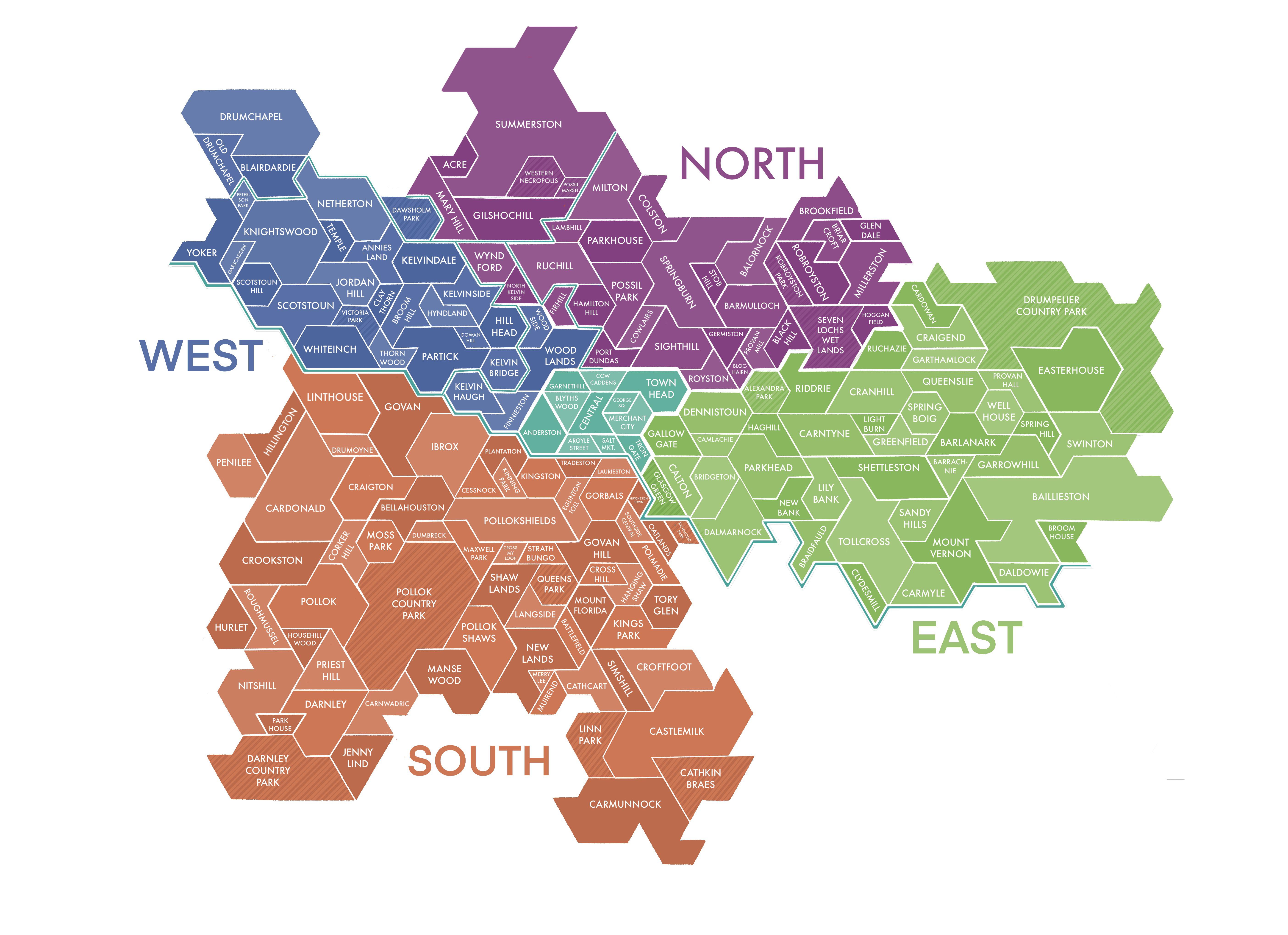
The city's geography can be broadly divided into four quadrants, each with a distinct identity that you can clearly see on any good map.
City Centre
The City Centre is the central sweep of development just north of the River Clyde. This large neighborhood contains Glasgow's coveted shopping districts. Lining the pedestrianized Sauchiehall, Buchanan, and Argyle streets are a number of department stores, boutique shops, and high-end chains.
For those seeking indoor retail, Buchanan Galleries and St. Enoch Square are popular destinations. This area also serves as a hub for entertainment, including independent cinema at the Glasgow Film Theatre.
Cathedral And East End
The City Centre's northeastern neighbor, historically known as Cathedral or Townhead, is defined by its ancient landmarks.
The magnificent Glasgow Cathedral, a site of religious importance since the fifth century, anchors this area. The adjacent Glasgow Necropolis, a vast Victorian cemetery, makes for a peaceful and meditative stroll with its acres of rolling green hills.
To the east of this historic core lies the Trongate and East End, a neighborhood most famous for the vibrant Barras Market, which sells everything from food to furniture, and the historic Tron Theatre, a 16th-century church turned contemporary venue. This area is also home to Glasgow Green, one of the city's oldest public parks.
Merchant City
Southeast of the City Centre, the Merchant City's boundaries run from George Square in the north to Argyle and Trongate streets in the south. This neighborhood is brimming with elegant Georgian and Victorian architecture, represented in the iconic City Chambers building, and is one of the few residential districts in the core of the city.
While it has a quieter, historical feel during the day, it comes alive at night with a healthy array of clubs, bars, and fine dining restaurants, leading many to compare it to New York's Soho.
West End
Anchored by the University of Glasgow, a towering example of neo-Gothic architecture, the West End bursts with youth and energy. This area has a refined bohemian ambiance, where secondhand shops, ethnic eateries, and leafy parks mingle with opulent homes and high-end stores.
It is also home to the Riverside Museum and the world-class Kelvingrove Art Gallery and Museum. The Botanic Gardens and Kibble Palace are more tourist favorites, providing a verdant oasis just off the main drag of Byres Road.
Southside
Located across the River Clyde from the City Centre, the Southside is a vast and diverse area. It is characterized by its charming traditional tenements, expansive parks like Pollok Country Park, and a thriving local food scene. This area is less tourist-focused than the West End or City Centre, offering a more authentic feel of local Glaswegian life.
Related Reading: Scotland Map - Explore Cities, Highlands, And Islands In Detail
Glasgow City Map
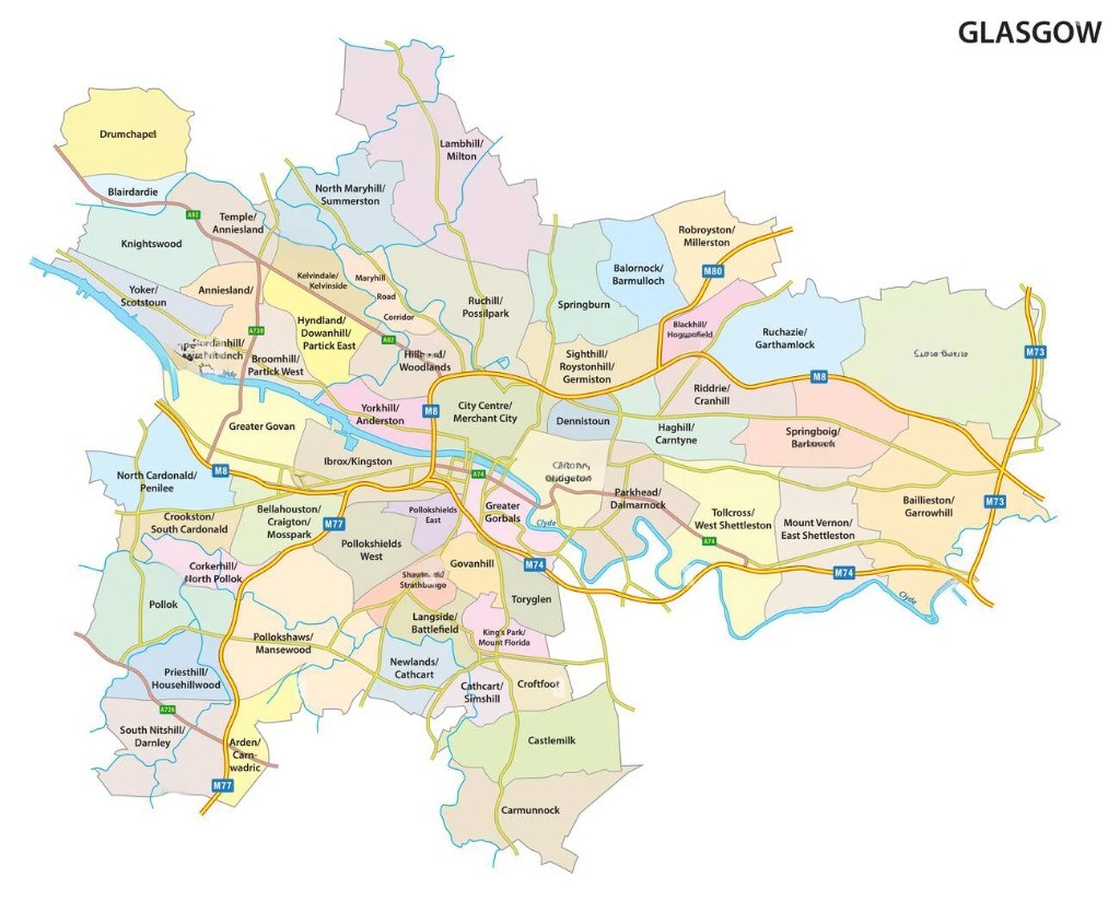
Modern administrative divisions, like the current HSCP localities-North East, North West, and South-trace their legacy back through these older frameworks. Even today’s 23 multi-member wards, shown on official civic maps, echo older parish and municipal boundaries visible in older records.
Modern & Thematic Maps
Today, the "Glasgow City Map" experience is predominantly digital. Platforms like Google Maps and Apple Maps have revolutionized how we interact with the urban landscape, offering real-time traffic updates, public transport routes, and walking directions.
The beauty of modern digital maps lies in their layered information, allowing you to customize your view to suit your needs. Beyond these general-purpose tools, Glasgow's unique character has inspired a range of specialized thematic maps that offer unique perspectives on the city.
Glasgow Subway Map
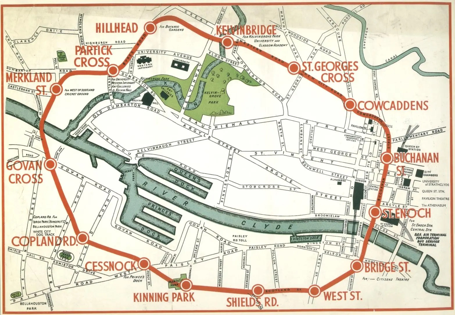
Affectionately known as the "Clockwork Orange" due to its distinctive orange livery and circular route, the Glasgow Subway is one of the oldest underground railway systems in the world. A dedicated Glasgow Subway map is indispensable for navigating this efficient network, which serves the city center and parts of the West End and Southside.
The map's simplicity is its strength: a single circular line with an Outer Circle and an Inner Circle. This straightforward design makes it incredibly easy to understand, even for first-time visitors. The map clearly marks all 15 stations, allowing you to quickly identify your closest stop and destination.
Many digital map applications also integrate the subway lines, offering real-time arrival information and journey planning. Understanding the subway map is key to quickly traversing the city's core without battling surface traffic.
Map Of Glasgow West End
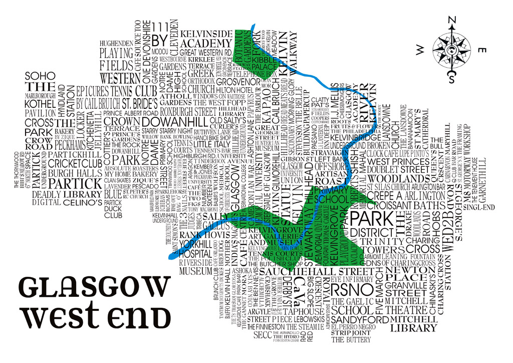
The West End of Glasgow is a distinctive and highly sought-after district, celebrated for its bohemian charm, academic institutions, leafy avenues, and impressive Victorian architecture.
A dedicated map of Glasgow West End reveals its unique layout, diverging from the more structured grid of the city center. This area is characterized by elegant crescents, charming mews, and a higher density of parks and green spaces.
On a West End map, you'll easily spot iconic landmarks like the University of Glasgow, with its stunning Gothic revival architecture dominating the skyline. Kelvingrove Art Gallery and Museum, one of Scotland's most popular attractions, is also a prominent feature, nestled beside the River Kelvin.
The map will also highlight the Botanic Gardens, a verdant oasis, and the bustling Byres Road, the main artery of the West End, dotted with independent shops, cafes, and restaurants.
Exploring the map allows you to visualize the charming lanes, such as Ashton Lane, and the proximity of residential areas to vibrant commercial and cultural hubs, making it an ideal tool for both residents and visitors eager to immerse themselves in this vibrant quarter.
Glasgow Mural Trail Map
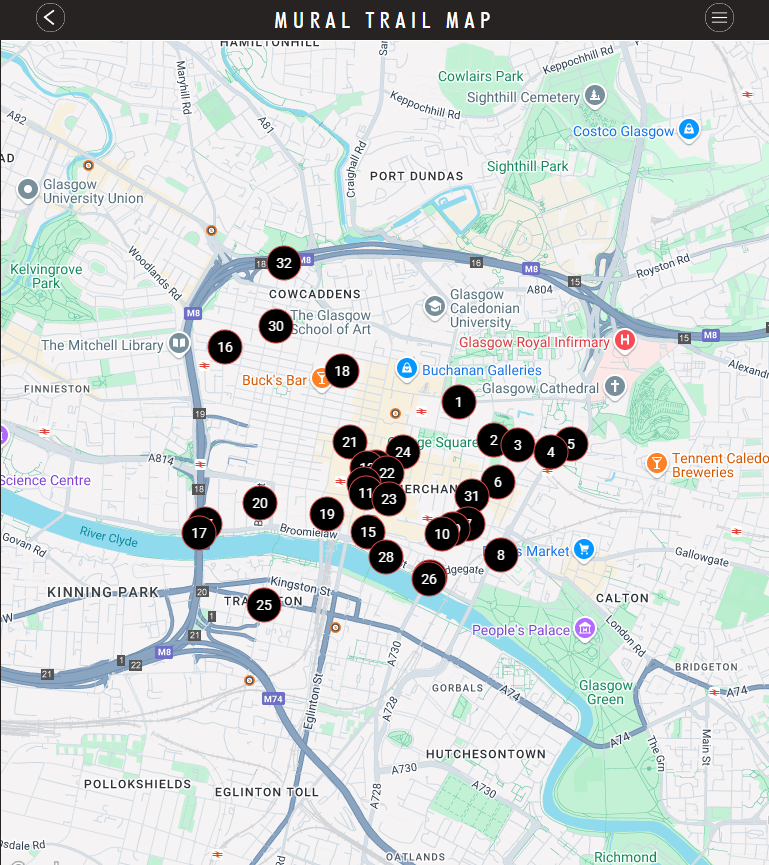
Glasgow has transformed itself into a vibrant outdoor art gallery, with stunning street art adorning buildings throughout the city center and beyond. The Glasgow Mural Trail Map is an absolute must-have for anyone looking to discover these impressive, large-scale artworks. This specialized map pinpoints the exact locations of each mural, guiding you on an artistic adventure through the urban landscape.
The murals themselves range from whimsical and historical to thought-provoking and abstract, often depicting aspects of Glasgow's heritage, famous Glaswegians, or its unique humor. A dedicated mural trail map not only helps you locate each piece but often provides context about the artist and the meaning behind the artwork.
Following the trail is a fantastic way to explore the city on foot, discovering hidden lanes and vibrant neighborhoods you might otherwise miss. It turns a simple walk into an engaging cultural experience, highlighting Glasgow's creative spirit.
Glasgow Road & Airport Map
Glasgow Street Map
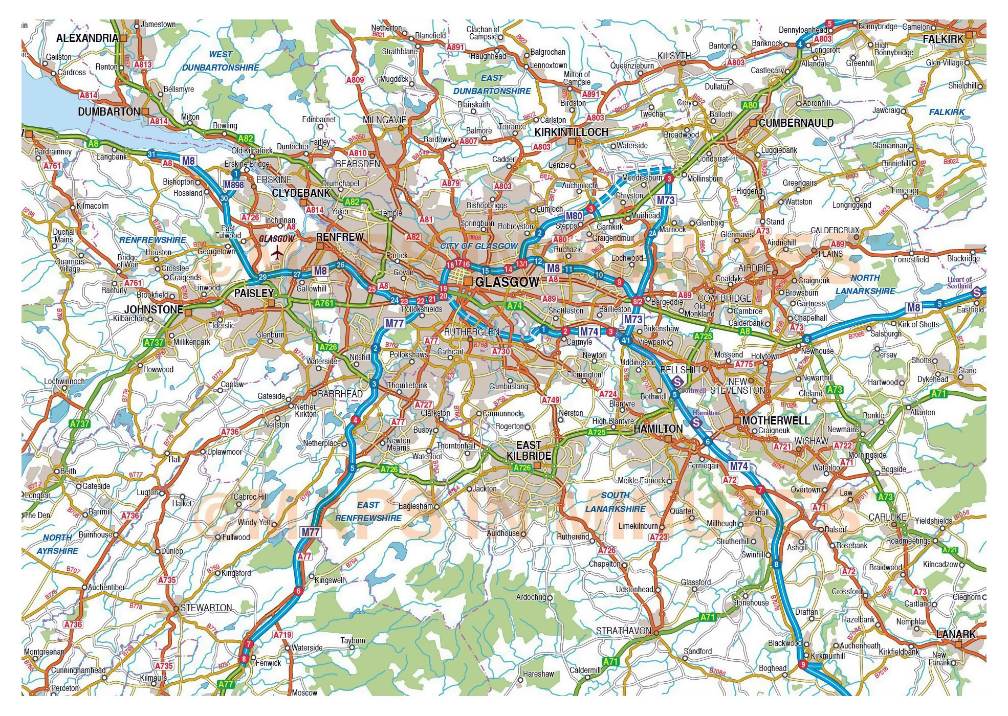
For those venturing beyond the immediate city confines, a large road map of Glasgow and its surrounding area, prominently featuring airports, becomes invaluable. This type of map moves beyond local navigation, providing a broader perspective on the region's interconnectedness. It lays out the intricate network of motorways (like the M8, M74, M77), A-roads, and secondary routes that link Glasgow to the rest of Scotland and the wider UK.
Crucially, these maps highlight the strategic locations of Glasgow's primary international airport (GLA) and the nearby Glasgow Prestwick Airport (PIK). Glasgow International Airport is conveniently situated just 8 miles west of the city center, directly off Junction 28 of the M8 motorway, making its access straightforward and efficient.
Prestwick Airport, further southwest in Ayrshire, is also clearly marked, often showing its direct rail link to Glasgow Central, offering an alternative for travelers. Furthermore, a comprehensive regional road map will often include the connections to Edinburgh Airport (EDI), situated east of Glasgow, accessible via the M8 motorway.
Understanding these road arteries and their relationship to the airports is vital for planning regional travel, freight logistics, and even understanding the commuter patterns that influence the city's broader economic landscape. Such a map underscores Glasgow's position as a gateway to both the west coast of Scotland and the Central Belt.
Tourist Map Of Glasgow City Center
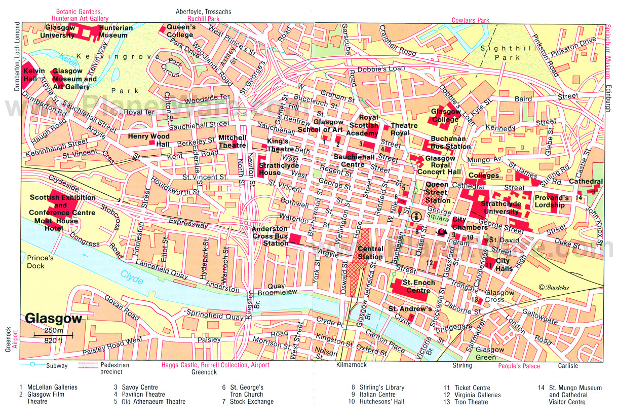
When visiting Glasgow, a dedicated tourist map of the city center becomes your essential companion. Unlike a purely functional street map, a tourist map is designed with the visitor's experience in mind, emphasizing attractions, cultural venues, and popular shopping districts. It often features clearer, more visually appealing iconography for landmarks, museums, galleries, and historic sites.
A typical Glasgow city center tourist map will prominently mark key points of interest such as George Square (the city's civic heart), the Gallery of Modern Art (GoMA), the Lighthouse (Scotland's Centre for Architecture and Design), and the vibrant shopping arteries of Buchanan Street, Argyle Street, and Sauchiehall Street.
It will also highlight pedestrianized zones, public transport hubs like Glasgow Central and Queen Street train stations, and key subway stops, making it easy to navigate the compact and walkable core.
Many tourist maps also include suggestions for walking trails, public restrooms, and visitor information centers, ensuring you can make the most of your time exploring Glasgow's bustling urban core. These maps simplify the city for discovery, pointing you toward the experiences that define Glasgow.
Top Places To Visit On The Glasgow Map
A city map is more than just a navigational tool; it's a guide to experiences. Here are some of the top places you can pinpoint on a Glasgow city mapto begin your journey through Scotland’s cultural capital.
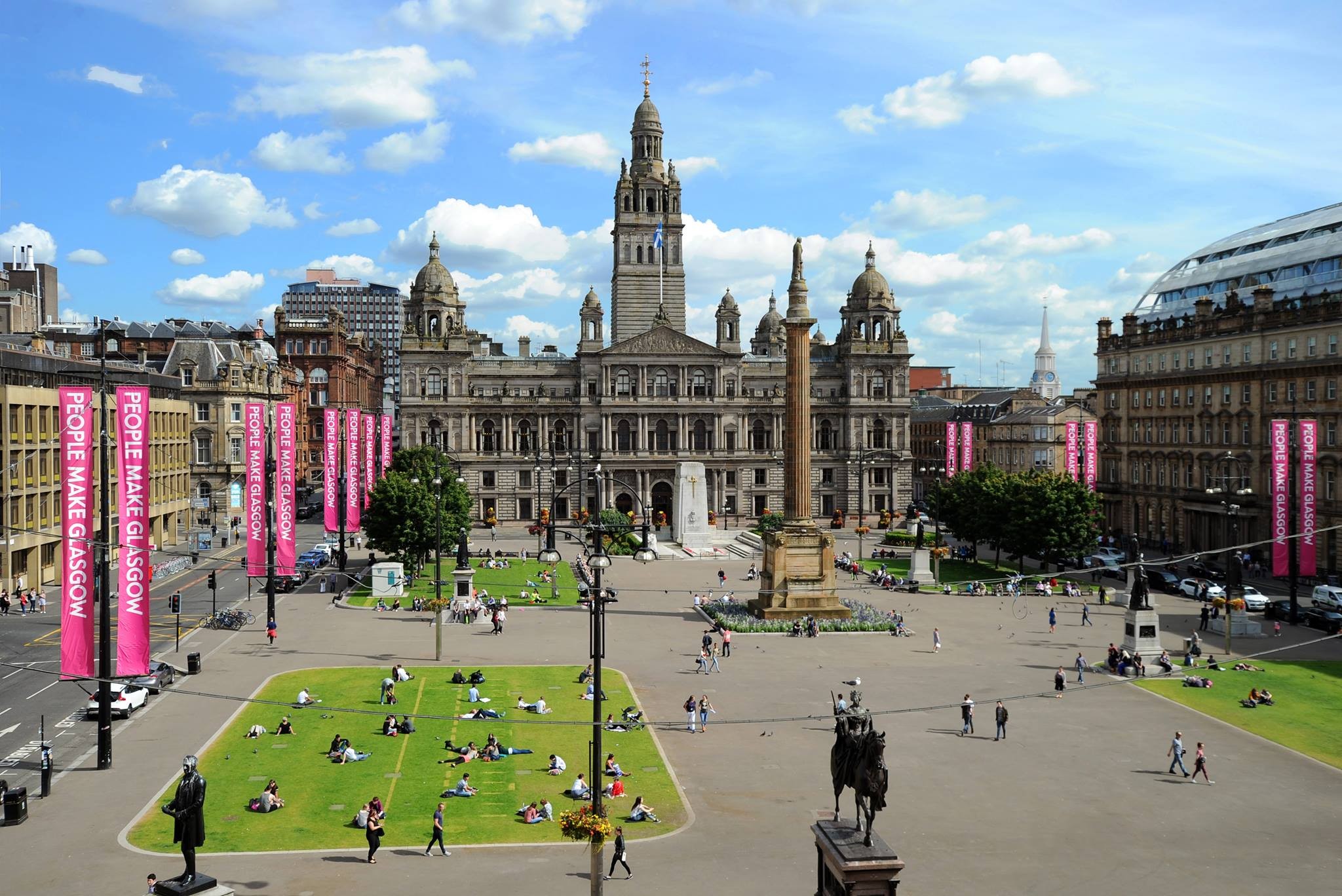
George Square & Glasgow City Chambers
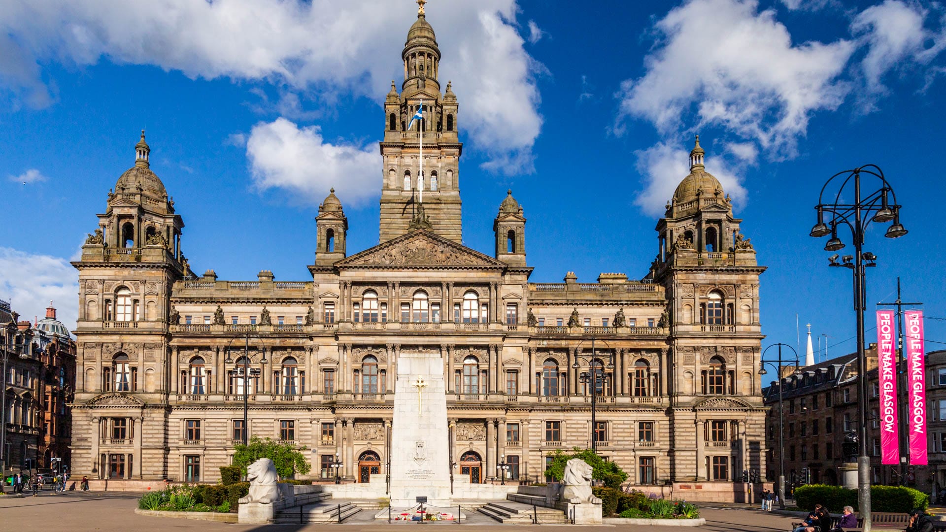
Located in the heart of the city, George Squareis Glasgow’s main civic space, framed by statues of historical figures and grand 19th-century architecture. It serves as a central gathering point for festivals, public events, and protests.
Dominating the square is the Glasgow City Chambers, an architectural masterpiece completed in 1888. Its elaborate marble interiors and ornate chambers are open for public tours, offering a glimpse into the city's political life and Victorian opulence.
Kelvingrove Art Gallery And Museum
Set within Kelvingrove Parkin the vibrant West End, the Kelvingrove Art Gallery and Museumis one of the most visited free attractions in the UK. It houses over 8,000 artifacts across diverse themes-from Renaissance art to Scottish arms and armor.
Highlights include Salvador Dalí’s Christ of Saint John of the Cross, a Spitfire hanging from the ceiling, and a life-size elephant. The red sandstone building itself is a striking example of Spanish Baroque architecture.
University Of Glasgow
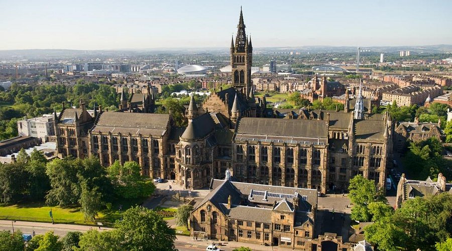
Founded in 1451, the University of Glasgowis one of the oldest universities in the English-speaking world. Its main building, designed in the Gothic Revival style, is perched above Kelvingrove Park and resembles something from a Harry Potter film.
Visitors can stroll through The Cloisters, explore the Hunterian Museum, or simply admire panoramic views of the West End and River Clyde. It’s a center of learning and a work of architectural art.
The Tall Ship Glenlee
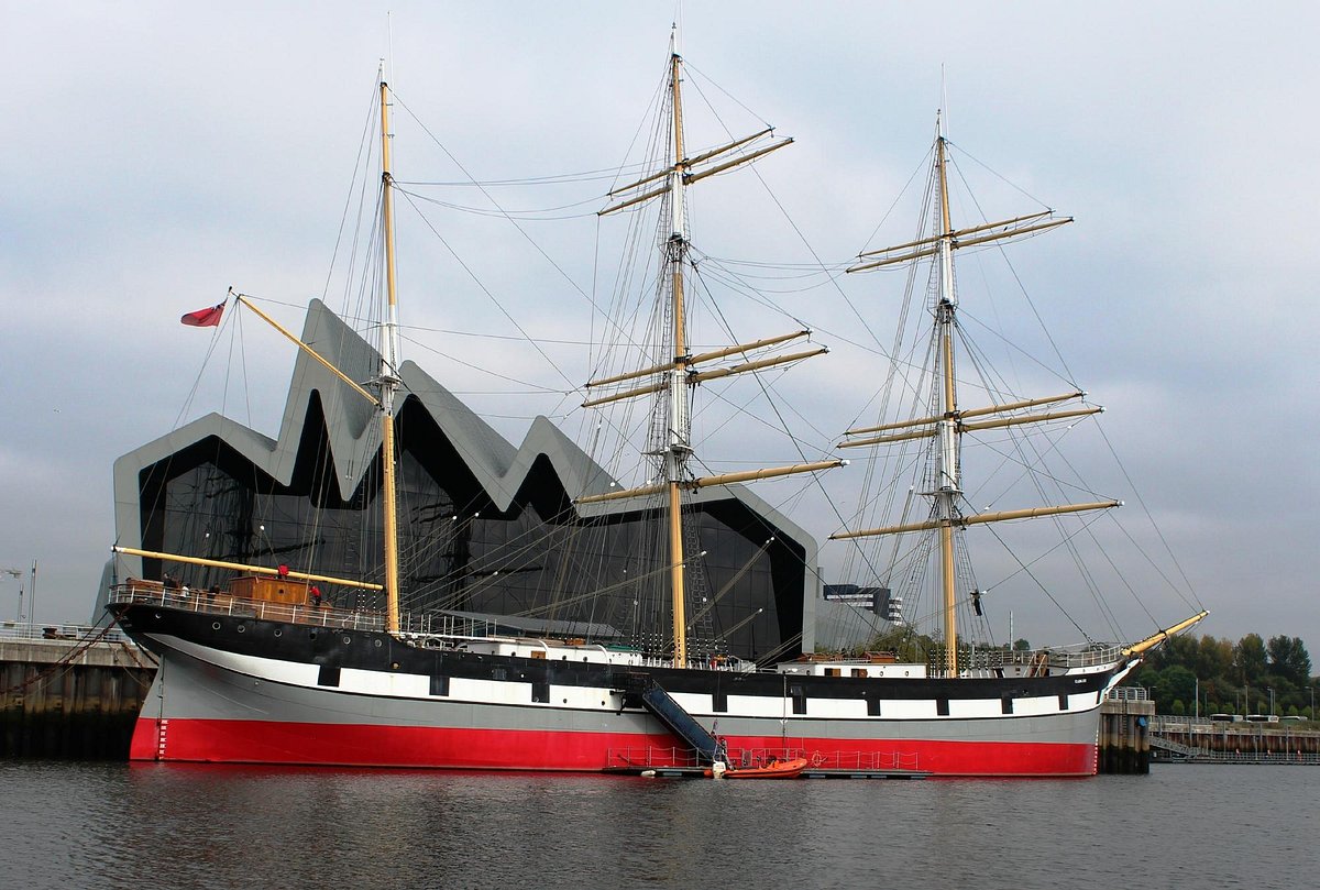
Docked beside the Riverside Museum, The Tall Ship Glenleeis a beautifully restored 19th-century sailing ship built on the Clyde in 1896. It's one of only a few Clyde-built tall ships still afloat today.
Visitors can climb aboard and explore the ship’s decks, cabins, and cargo hold. Interactive exhibits bring maritime history to life, and there's a play area for children. It’s an immersive way to experience Glasgow’s shipbuilding heritage.
Riverside Museum
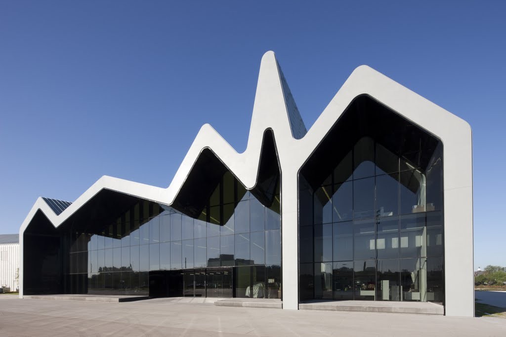
Right next door of The Tall Ship Glenleeis the award-winning designed by the late Zaha Hadid, the Riverside Museumis one of Glasgow’s most striking modern buildings. Opened in 2011, it houses the city’s Museum of Transport, showcasing everything from vintage cars and bicycles to trams, skateboards, and locomotives.
The museum includes recreated historic Glasgow streets and interactive exhibits that appeal to both adults and children. It’s a celebration of Glasgow’s industrial legacy, located right on the banks of the River Clyde.
Glasgow Cathedral & The Necropolis
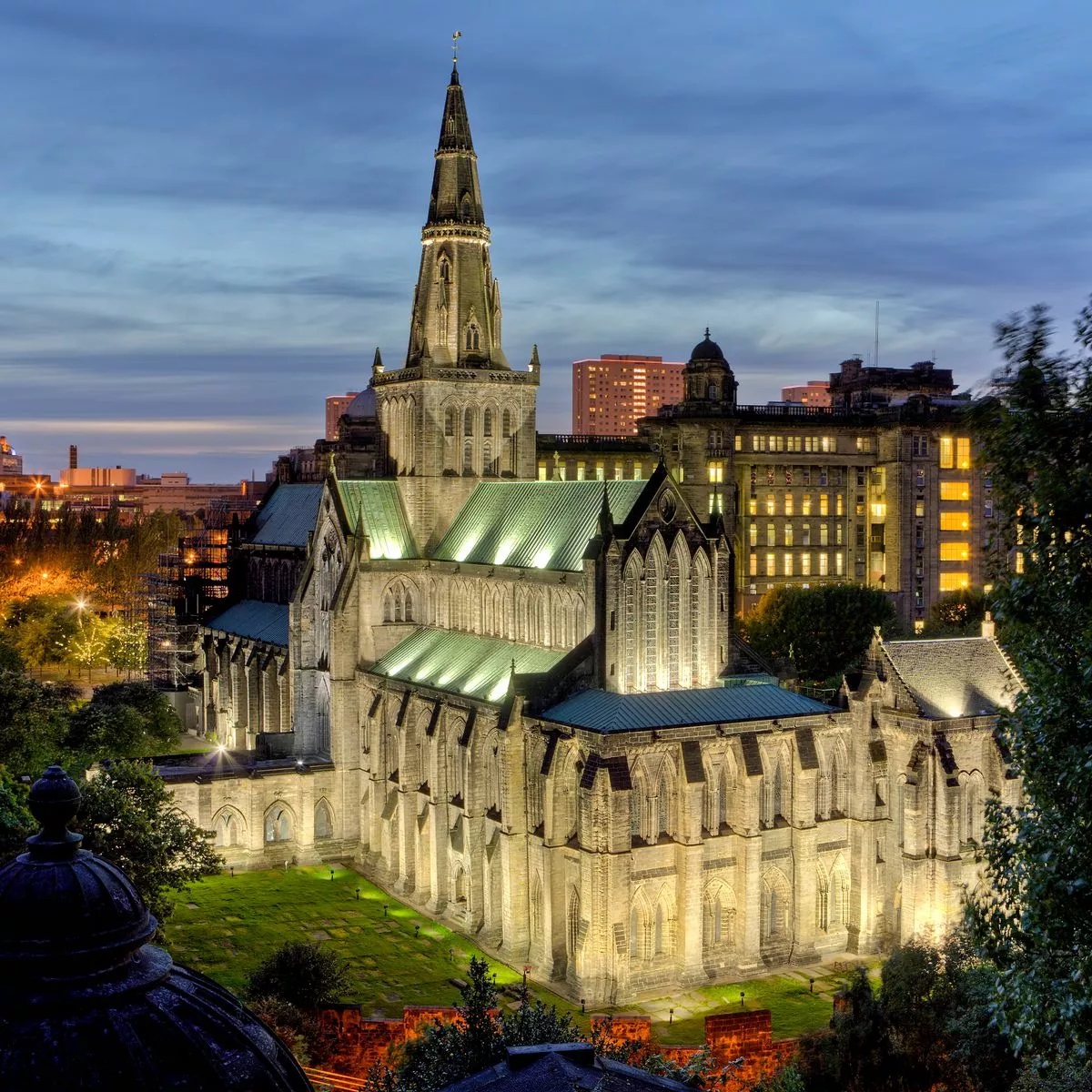
Glasgow Cathedral, also known as St. Mungo’s Cathedral, is a rare example of a medieval Scottish church that survived the Reformation largely intact. Dating back to the 12th century, it features dramatic Gothic architecture and stunning stained glass.
Climb the nearby Glasgow Necropolis, a Victorian-era garden cemetery, for panoramic views over the city. Lined with elaborate tombs and statues, it’s a peaceful yet evocative site that captures the spirit of old Glasgow.
Pollok Country Park
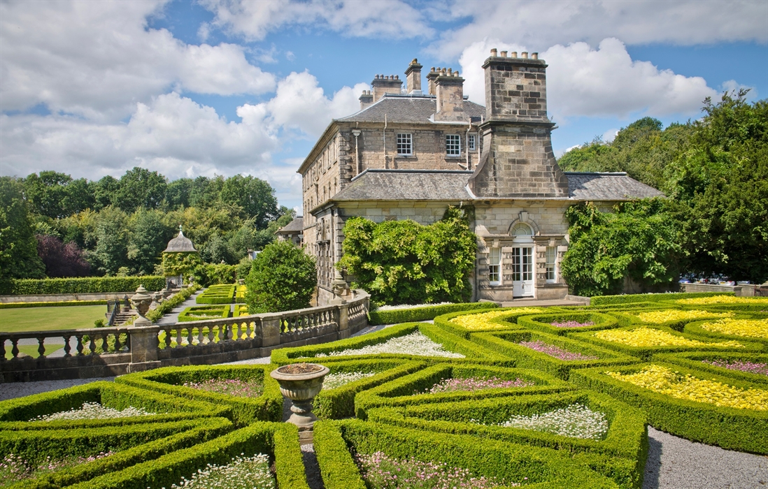
Voted Britain’s Best Park, Pollok Country Parkis a vast green oasis in Glasgow’s Southside. It offers tranquil woodlands, riverside paths, and manicured gardens that contrast beautifully with the urban surroundings.
Key attractions include:
- Pollok House- a grand 18th-century country estate with period interiors and art collections.
- The Burrell Collection- home to over 9,000 works, including medieval tapestries, Chinese ceramics, and Rodin sculptures.
- Highland Cows- the park is famous for its photogenic, ginger-haired coos.
Ideal for families, joggers, cyclists, and art lovers, it’s one of the city’s best spots to unwind.
Exploring Historical Maps
Delving into historical maps of Glasgow is like stepping into a time machine. These cartographic artifacts aren't just navigational tools; they are windows into the city's past, revealing its transformation from a burgeoning burgh to a global industrial powerhouse. Examining old maps allows us to trace the evolution of street names, the disappearance of ancient lanes, and the emergence of iconic landmarks.
For instance, early maps might show the rudimentary street plan around Glasgow Cathedral, a far cry from the sophisticated grid system that later defined much of the city center.
The gradual expansion westwards, with the development of grand Victorian terraces and parks, is also vividly captured. These historical documents often highlight the city's crucial role in shipbuilding and trade, with detailed depictions of docks and warehouses along the Clyde.
Where to explore historical Glasgow maps:
- Historic Towns Trust:Offers downloadable historical maps of Glasgow, including those detailing its medieval street names and 1800s layout.
- National Library of Scotland (Maps Section):A vast digital archive of historic Scottish maps, including many of Glasgow.
- Mitchell Library (Glasgow):Home to extensive local history collections, including a wealth of historical maps.
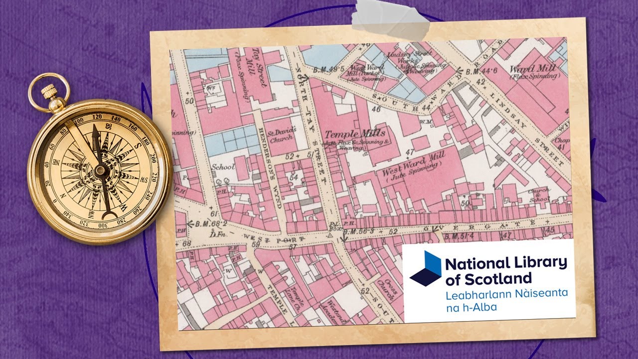
Discover Historic Maps at the National Library of Scotland - Laragh Quinney
This video provides a great tutorial on how to use the online resources of the National Library of Scotland, which is mentioned in the article as a key source for historical maps.
Language Of Glasgow
The primary language spoken in Glasgow is English, with a distinct local dialect known as Glaswegian. However, like the rest of Scotland, Scots and Scottish Gaelic are also officially recognized indigenous languages.
- English:The main language used in all official documents, signage, and everyday life.
- Scots:A Germanic language with historical roots in the Scottish Lowlands, often heard in everyday conversation and considered an important part of Scottish cultural identity.
- Scottish Gaelic:A Celtic language, Gaelic has experienced a recent revival and is taught in Glasgow's Gaelic-medium schools, though it is more prevalent in the Highlands and Islands.
Currency Of Glasgow
The currency used in Glasgow, and throughout Scotland, is the Pound Sterling (£), which is the official currency of the United Kingdom.
While the value of the currency is the same, it's worth noting that Scottish banks issue their own banknotes, which look different from those issued by the Bank of England. Both Scottish and Bank of England notes are legal currency and are accepted throughout Scotland.
10 Fascinating Facts About Glasgow That Might Surprise You
Glasgow is a city full of rich history, cultural marvels, and quirky surprises. From ancient fossils to Victorian opulence, here are ten intriguing facts that showcase the unique spirit of Scotland’s largest city.
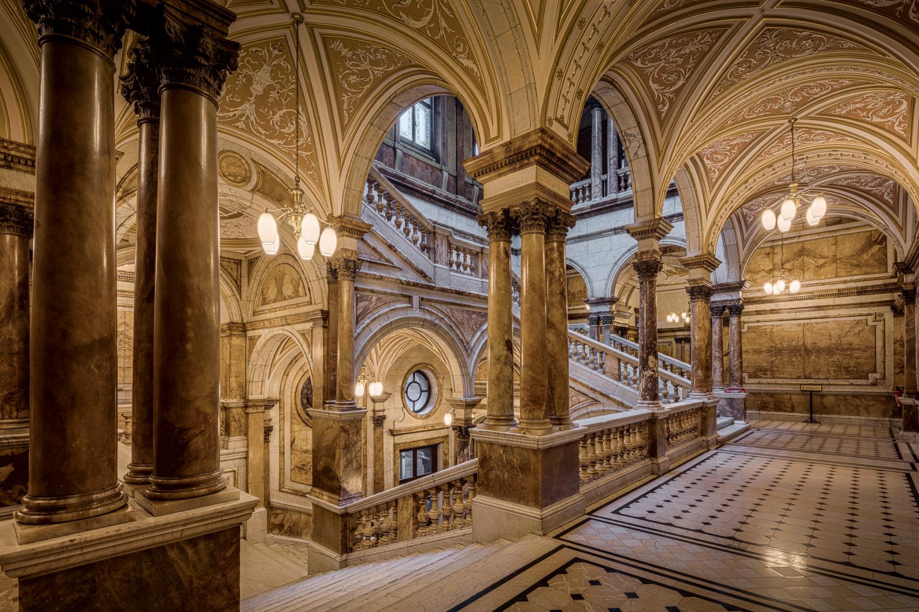
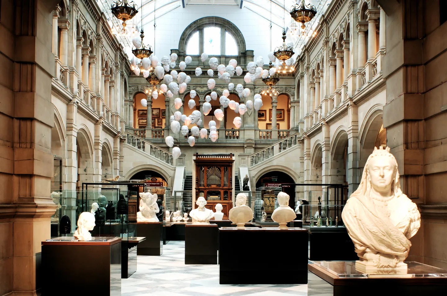
1. Glasgow City Chambers Has More Marble Than The Vatican
Standing proudly in George Square, the Glasgow City Chambersis a jewel of Victorian architecture. Opened in 1888, its lavish interiors contain more marble than Vatican City, making it a popular stand-in for the Vatican in films. The grand staircases, ornate ceilings, and polished stonework make it a must-visit for lovers of architecture and history.
2. Fossil Trees In Glasgow Are Older Than Dinosaurs
Tucked away in Fossil Grove, eleven fossilized tree stumps-estimated to be 330 million years old-have been preserved since their discovery in 1887. That makes them older than the dinosaurs. Today, they’re housed in a Victorian-era museum and remain one of Glasgow’s most awe-inspiring natural wonders.
3. The Name Glasgow Means ‘Dear Green Place’
In Gaelic, Glaschutranslates to "dear green place"-a name well-earned, given the city boasts over 90 parks and gardens. From the rolling lawns of Kelvingrove Parkto the serenity of Botanic Gardensand the poetic charm of Maxwell Park, greenery is never far from reach.
4. Glasgow’s Gallery Of Modern Art Was Once A Tobacco Lord’s Mansion
Before it became the Gallery of Modern Art (GoMA), this iconic neoclassical building was the lavish townhouse of William Cunninghame, a wealthy 18th-century tobacco merchant. Later adapted by architect David Hamilton in the 1800s, it now houses contemporary art beneath Corinthian columns and a grand cupola.
5. The Glasgow Subway Is The Third Oldest In The World
Nicknamed the “Clockwork Orange”for its bright trains, Glasgow’s subway system opened in 1896-making it the third oldest underground railway on Earth. Despite its age, it still operates on its original 10.5-kilometre circular route, the only metro of its kind in Scotland.
6. Glasgow Cathedral Survived The Protestant Reformation
Glasgow Cathedral, built in the 12th century atop the tomb of St. Mungo, is a rare survivor of the Protestant Reformation of 1560. While many other Catholic buildings were destroyed or repurposed, this Gothic landmark remained remarkably intact and continues to draw visitors with its rich history and dramatic architecture.
7. The First Ultrasound Machine Was Invented In Glasgow
Medical history was made in Glasgow in 1956, when Professor Ian Donald and his team developed the first ultrasound scanner. This groundbreaking invention revolutionized prenatal care. You can view the original prototype at the Hunterian Museumat the University of Glasgow.
8. The Remains Of Saint Valentine Are Kept In Glasgow
Yes, the bones of Saint Valentine-the 3rd-century Roman saint—rest in a small wooden box at St. John Duns Scotus Churchin the Gorbals. Each Valentine’s Day, the relics are adorned with flowers in honor of the patron saint of love. Glasgow's claim to this romantic legacy is just one of many international locations that share a piece of his story.
9. The World’s First International Football Match Was Played Here
Glasgow hosted the first official international football matchon November 30, 1872, between Scotland and England at the West of Scotland Cricket Ground. The game ended in a 0-0 draw but marked a historic milestone in sports, recognized by FIFA as the first of its kind. Over 4,000 spectators attended, paying just one shilling to witness history.
10. The Tall Ship Glenlee Is A Rare Survivor Of The Clyde’s Shipbuilding Legacy
The Tall Ship Glenlee, launched in 1896, is one of only five Clyde-built sailing ships still afloat-and the only one in the UK. After decades of travel and restoration, the Glenlee is now permanently docked beside the Riverside Museum, where visitors can climb aboard and experience Glasgow’s maritime legacy firsthand.
You Might Like: Traditional And Modern Scottish Eats In Glasgow
FAQs About Glasgow City Map
What Kind Of Glasgow City Maps Are Available?
You can find various types, including historical maps, modern street maps, digital interactive maps (like Google Maps), and thematic maps focusing on specific interests like murals, green spaces, or cultural attractions.
Where Can I Get A Physical Map Of Glasgow?
Physical maps can often be found at tourist information centers, bookshops, and some larger hotel lobbies in Glasgow. Many online travel resources also offer printable maps.
What's The Best Map For Public Transport In Glasgow?
Digital maps like Google Maps or official transport apps often provide the most up-to-date public transport routes and real-time information for Glasgow's subway, bus, and train services.
What Is The Nicest Area Of Glasgow?
The West Endis widely considered the nicest area in Glasgow. Known for its leafy streets, elegant Victorian architecture, and cultural institutions like the Kelvingrove Art Gallery and Museumand University of Glasgow, the West End offers a mix of bohemian charm and historic grandeur.
Areas like Hillhead, Partick, and Dowanhillare especially popular for their vibrant café culture, artisan shops, and proximity to green spaces like Kelvingrove Parkand the Botanic Gardens.
What Is Glasgow Most Famous For?
Glasgow is most famous for its vibrant arts scene, Victorian architecture, and legendary music and nightlife. As Scotland’s largest city, it's a cultural powerhouse that blends industrial heritage with modern creativity.
It's home to world-class museums (most of which are free), a thriving live music culture that earned it the title "UNESCO City of Music," and an impressive range of street art and murals that can be explored through the Glasgow Mural Trail.
What Is The Most Scenic Part Of Glasgow?
The Kelvingrove and West End area offers some of the most scenic views in Glasgow. Walking along the River Kelvin, through Kelvingrove Park, or around the University of Glasgow’s Gothic campus provides striking views of architecture, greenery, and urban life blending beautifully.
The South Side is also scenic in places like Pollok Country Park (home to Pollok House and Highland cows), and Glasgow Green offers historic vistas near the People's Palace and the River Clyde.
Is Glasgow A Walking City?
Yes, Glasgow is very walkable, especially the city centre and surrounding neighborhoods like the West End and Merchant City.
Final Thoughts
A "Glasgow City Map" is far more than a simple guide; it's an invitation to explore a city rich in history, vibrant culture, and forward-thinking innovation.
From tracing the footsteps of industrial giants on historical charts to navigating its lively neighborhoods with cutting-edge digital tools, understanding Glasgow through its maps offers a unique and profound connection to this remarkable Scottish metropolis. Embrace the opportunity to see Glasgow not just as a collection of streets, but as a living, evolving tapestry waiting to be discovered.
If you found this exploration of Glasgow's maps insightful, please share it with others who might be planning a visit or simply curious about this incredible city!
Jump to
Navigate Glasgow Like A Local: Discover Its Districts, History & Hidden Secrets
Quick Facts About Glasgow
Glasgow's Geography
Glasgow City Map
Modern & Thematic Maps
Glasgow Subway Map
Map Of Glasgow West End
Glasgow Mural Trail Map
Glasgow Road & Airport Map
Tourist Map Of Glasgow City Center
Top Places To Visit On The Glasgow Map
Exploring Historical Maps
Language Of Glasgow
Currency Of Glasgow
10 Fascinating Facts About Glasgow That Might Surprise You
FAQs About Glasgow City Map
Final Thoughts

Callum Fraser
Author
Callum Fraser isn't just a writer about Scotland; he's a product of its rugged landscape and rich history. Born and raised in Perthshire, with the Highlands as his backyard, his love for the nation's stories was kindled by local storytellers and long walks through ancient glens.
This passion led him to pursue a degree in Scottish History from the University of Edinburgh. For over 15 years, Callum has dedicated himself to exploring and documenting his homeland, fusing his academic knowledge with essential, on-the-ground experience gained from charting road trips through the Cairngorms, hiking the misty Cuillins of Skye, and uncovering the secrets of traditional recipes in his family's kitchen.
As the Editor-in-Chief and Lead Author for Scotland's Enchanting Kingdom, Callum's mission is simple: to be your most trusted guide. He combines meticulous research with a storyteller's heart to help you discover the authentic magic of Scotland — from its best-kept travel secrets to its most cherished traditional recipes.
Latest Articles
Popular Articles