Map Of Brodick Arran | Key Landmarks, Walks & Travel Info
Plan your trip with this map of Brodick, Arran, featuring top landmarks, scenic walks, and travel info to help you get around with ease.
Author:Callum FraserAug 25, 20252.7K Shares94.7K Views
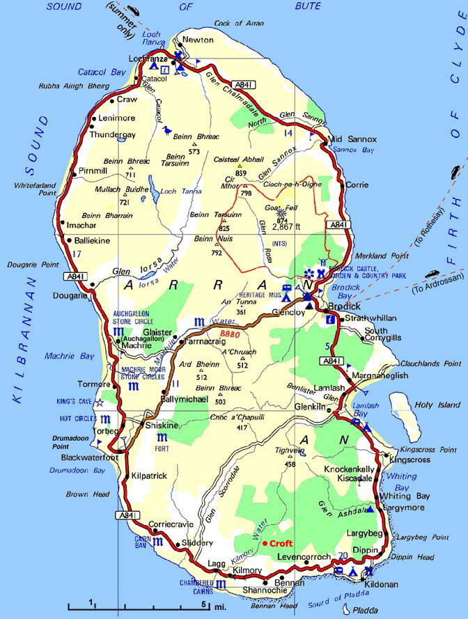
Your Handy Map Of Brodick Arran For Landmarks, Walks & Travel Info
Brodick is the main village on the Isle of Arran and the first stop for most visitors arriving by ferry. It’s a great base for walks, sightseeing, and local adventures.
A good map of Brodick Arrancan make your visit easier and more enjoyable. It helps you find key landmarks, walking trails, and local highlights. You’ll find useful tips and the best maps for walking, driving, or planning your time in Brodick.
Quick Facts About Brodick, Arran
- Location: East coast of the Isle of Arran, Scotland
- Island: Part of the Isle of Arran, in the Firth of Clyde
- Ferry Port: Main ferry terminal connecting Arran to Ardrossan on the mainland
- Population: 600 people
- Famous Landmark: Brodick Castle and Gardens
- Nearby Mountain: Goat Fell (874 metres), the highest point on Arran
- Tourist Hub: Most visitors arrive and stay here
- Shops & Services: Contains supermarkets, hotels, cafés, and visitor services
- Walking Trails: Starting point for popular walks like Goat Fell and Fisherman’s Walk
- Transport: Buses connect Brodick with other parts of Arran
- Climate: Mild, with cool summers and wet winters
- Name Meaning: Brodick comes from the Old Norse word "Brod-vik", meaning “broad bay”
Getting To Brodick: Ferry Information & Transport
Ferry Services To Brodick
Caledonian MacBrayne (CalMac) Ferry Service
- Route: Ardrossan (mainland) to Brodick
- Journey Time: 55 minutes
- Frequency: Up to 6 sailings daily (varies seasonally)
- Cost: Adults from £7.20, Cars from £31.60 (2025 prices)
- Booking: Advanced booking recommended, especially in summer
- Terminal: Brodick Ferry Terminal, Brodick Pier
Ferry Timetables (Summer 2025)
- First sailing from Ardrossan: 7:15 AM
- Last sailing from Ardrossan: 7:55 PM
- First sailing from Brodick: 8:40 AM
- Last sailing from Brodick: 8:45 PM
Getting To Ardrossan Ferry Terminal
- By Train: Direct trains from Glasgow Central to Ardrossan Harbour (45 minutes)
- By Car: M8 to Irvine, then A78 to Ardrossan (45 minutes from Glasgow)
- Parking: Long-stay car park at Ardrossan Harbour (£8 per day)
Transport On Arran
Bus Services: Stagecoach operates regular services around the island
- Route 323: Brodick to Lochranza (40 minutes)
- Route 324: Brodick to Blackwaterfoot (35 minutes)
- Day tickets available: Adults £8.50
Car Rental: Available in Brodick from:
- Arran Car Hire (Shore Road)
- McLellan Car Hire (Cladach)
Taxi Services: Local taxi companies operate from Brodick
- Arran Taxi Service: 01770 600 600
- Island Taxi: 01770 302 020
Planning Your Visit To Brodick
Best Time To Visit
Peak Season (June-August)
- Warmest weather (15-18°C average)
- Longest daylight hours
- All attractions open
- Higher accommodation prices
- Ferry services at maximum frequency
Shoulder Season (April-May, September-October)
- Mild weather and fewer crowds
- Lower accommodation rates
- Good for hiking and outdoor activities
- Some seasonal attractions may have reduced hours
Winter (November-March)
- Cooler temperatures (5-10°C)
- Reduced ferry services
- Some attractions closed
- Best for peaceful retreats and cozy pub visits
Geographical Overview Of Brodick, Arran
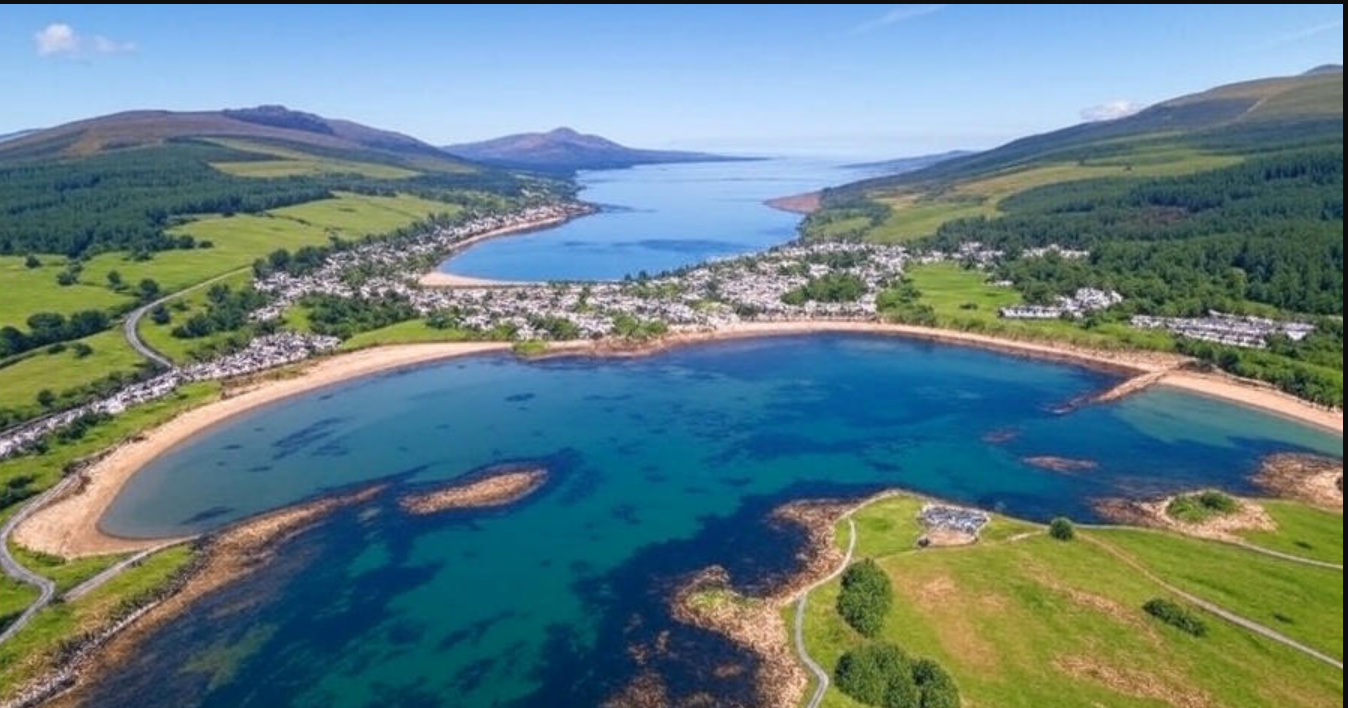
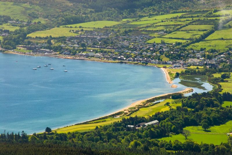
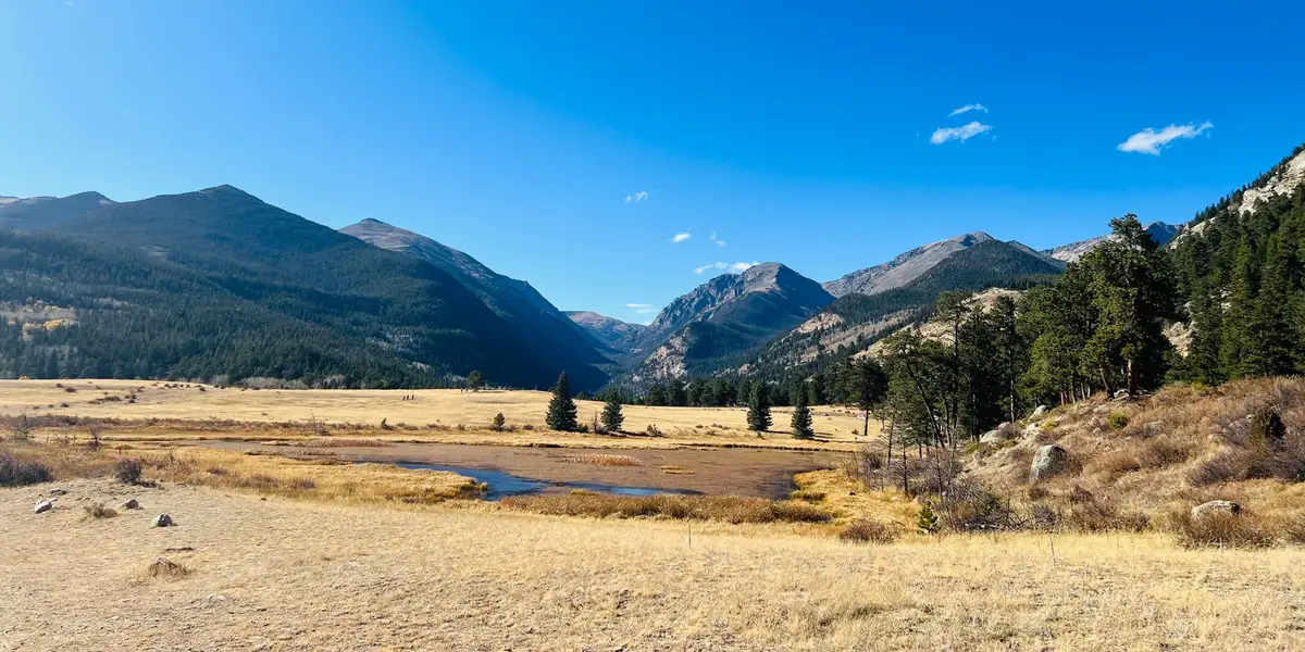
Brodick is a seaside village located on the east coast of the Isle of Arran, which sits in the Firth of Clyde on Scotland’s west coast. The island is often called "Scotland in miniature" because it has a mix of landscapes, mountains, forests, beaches, and farmland all in one place.
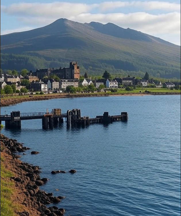
Brodick is backed by tall hills, including the famous Goat Fell, the highest peak on the island. Its location makes it the natural hub for visitors, with a ferry port, shops, hotels, and tourist services. Brodick Bay, with its calm waters and wide views, gives the village a peaceful, scenic setting. The surrounding geography is perfect for walking, cycling, and wildlife watching.
Its position in the middle of the east coast makes Brodick easy to reach and a great starting point for seeing the rest of Arran. You’ll also find that Brodick reflects many Scottish customs and traditions, offering a taste of authentic island culture through local events, crafts, and hospitality.
Capital Of Brodick, Arran
Brodick itself is not a capital in the traditional sense, but it is often seen as the main village or "capital" of the Isle of Arran. It's the largest settlement on the island and the center for transport, shopping, and tourism. The ferry from the mainland arrives in Brodick, and many visitors stay there during their trip.
It’s home to important landmarks like Brodick Castle, as well as government and public services, making it the island's unofficial capital. So, while the Isle of Arran doesn’t have a designated capital city, Brodick serves that role in every practical way.
Villages And Towns On The Map Of Brodick Arran
Brodick is the main village on the Isle of Arran and is often regarded as the island’s central hub. While Brodick is the largest settlement on Arran, it is important to note that the island does not have any cities. Instead, it is made up of several small towns and villages, each with its unique charm and character.
Brodick also offers a rich glimpse into Scottish culture, with its traditional architecture, local food, and welcoming community that reflects the island’s heritage. Here are several smaller villages and towns scattered around the island:
- Lamlash:A peaceful village located a few miles south of Brodick, known for its sandy beach and views over the Holy Isle.
- Blackwaterfoot:Located on the west coast, this village has a quiet atmosphere and access to rugged coastal scenery.
- Lochranza:Situated in the north, Lochranza is famous for its castle ruins and strong local whisky distillery.
- Shiskine:A small rural village known for its farming community and quiet environment.
- Kilmory:Found near the south, close to natural woodland areas and walking trails.
- Catacol:A tiny village with colorful houses, located on the northwest coast.
- Cladach:Located close to Brodick, this village offers access to beautiful beaches and local inns.
Regions On The Map Of Brodick Arran
East Arran
East Arran is where Brodick and nearby villages like Lamlash are found. This region has soft sandy beaches and gentle hills. It is the most visited part of the island because it offers many tourist facilities such as hotels, shops, and restaurants. Brodick Bay is the main harbor here, where ferries arrive from the mainland. The area is perfect for relaxing by the sea or enjoying easy walks.
North Arran
North Arran is quieter and less crowded. It includes smaller villages such as Lochranza. This region is known for its old castle ruins, giving it a rich historical feel. The land here is green with many forests and farms. It is a good place to visit for those who enjoy calm countryside and nature.
West Arran
West Arran is wilder and more rugged. Villages like Blackwaterfoot are in this area. The coast here is rocky and rough, and the land has open moorlands. It is less developed for tourists but offers a chance to see the island’s natural beauty in a quieter setting. This area is great for outdoor lovers who want to explore rougher landscapes.
Central Arran
The center of the island is full of hills and mountains, including Goat Fell, the highest peak on Arran. This region is perfect for hikers and nature fans. The land is mostly wild and natural, with forests and streams. It is a popular spot for people who want to enjoy challenging walks and see stunning views.
Population Of Brodick Arran
Brodick is the largest village on the Isle of Arran but remains small in size. Its population is around 600 people. This number can change slightly depending on the season because more visitors come in the summer months.
The Isle of Arran as a whole has about 5,000 residents, and Brodick is home to the most people. Many locals work in tourism, fishing, or local shops, helping to keep the village lively throughout the year.
Currency Of Brodick Arran
The currency used in Brodick, Arran, is the British Pound Sterling (£). This is the official money used across Scotland and the entire United Kingdom. Visitors coming to Brodick will need British pounds to buy goods, pay for services, or use public transport.
You can exchange money at banks, post offices, or currency exchange offices on the mainland before traveling. In Brodick, many shops, restaurants, and hotels accept credit and debit cards, but it is useful to have some cash for small purchases or places that may not take cards. ATMs are available in Brodick for easy access to cash.
Dialing Code Of Brodick Arran
The dialing code for Brodick Arran follows the UK telephone system. To call a number in Brodick from outside the UK, you first dial the UK country code +44, then the local area code without the initial zero, followed by the phone number.
For Brodick and the Isle of Arran, the local area code is 01770. So, if you are calling from abroad, you would dial +44 1770 followed by the phone number.
Language Of Brodick Arran
The main language spoken in Brodick and throughout the Isle of Arran is English. English is used in schools, shops, restaurants, and daily life. Visitors will have no trouble communicating with locals in English.
In addition to English, you might also hear some ScottishGaelic, especially among older residents or in cultural events. Scottish Gaelic is a traditional language in parts of Scotland, including the islands.
Flag Of Brodick Arran
Brodick and the Isle of Arran do not have their own official flag separate from Scotland. The island is part of Scotland, so the Scottish flag, known as the Saltire or St. Andrew’s Cross, represents the area.
The Scottish flag is a blue field with a white diagonal cross. It symbolizes Scotland’s patron saint, St. Andrew. You will see this flag flying on public buildings and during local events in Brodick.
Government Of Brodick Arran
Brodick is a village on the Isle of Arran, which is part of Scotland. It does not have its own local government like a city would. Instead, Brodick and the whole Isle of Arran are governed by the North Ayrshire Council. This council is responsible for making decisions about services like schools, roads, waste collection, and local planning.
The Isle of Arran also has a community council called the Arran Community Council. This group represents local people’s views and advises the North Ayrshire Council on issues affecting the island. The community council helps keep the local voice strong and works on improving life for residents and visitors.
In Scotland, laws and major decisions come from the Scottish Government based in Edinburgh. For national matters like health, education, and transport, Brodick follows rules set by the Scottish Government.
Total Area Of Brodick Arran
The Isle of Arran, where Brodick is located, covers about 432 square kilometers (or around 167 square miles). Brodick itself is a small village within this larger area.
Arran is the seventh largest island in Scotland. Its size offers plenty of space for nature, farms, small villages, and tourist spots. The landscape includes hills, forests, beaches, and valleys, making it a popular place for outdoor activities.
Though Brodick is the biggest village on the island, it occupies only a small part of the total area. The rest of the island is made up of countryside and smaller settlements.
Types Of Brodick Arran Map
Different maps of Brodick and the Isle of Arran serve various purposes. Here are the main types you might find:
- Tourist Maps: These show key attractions, hiking paths, and places to stay. Tourist maps help visitors plan trips to Brodick Castle, beaches, and walking routes.
- Road Maps: These maps highlight the roads, streets, and transport links on the island. They are useful for driving or cycling around Arran.
- Topographic Maps: These maps show the land’s natural features like hills, valleys, and elevation. Since Arran is hilly, these maps are popular with hikers and nature lovers.
- Village Maps: These detailed maps focus on Brodick itself, showing streets, shops, hotels, and public services. They help visitors find their way around the village.
Each type of map gives a different view, helping residents and tourists understand Brodick and Arran better.
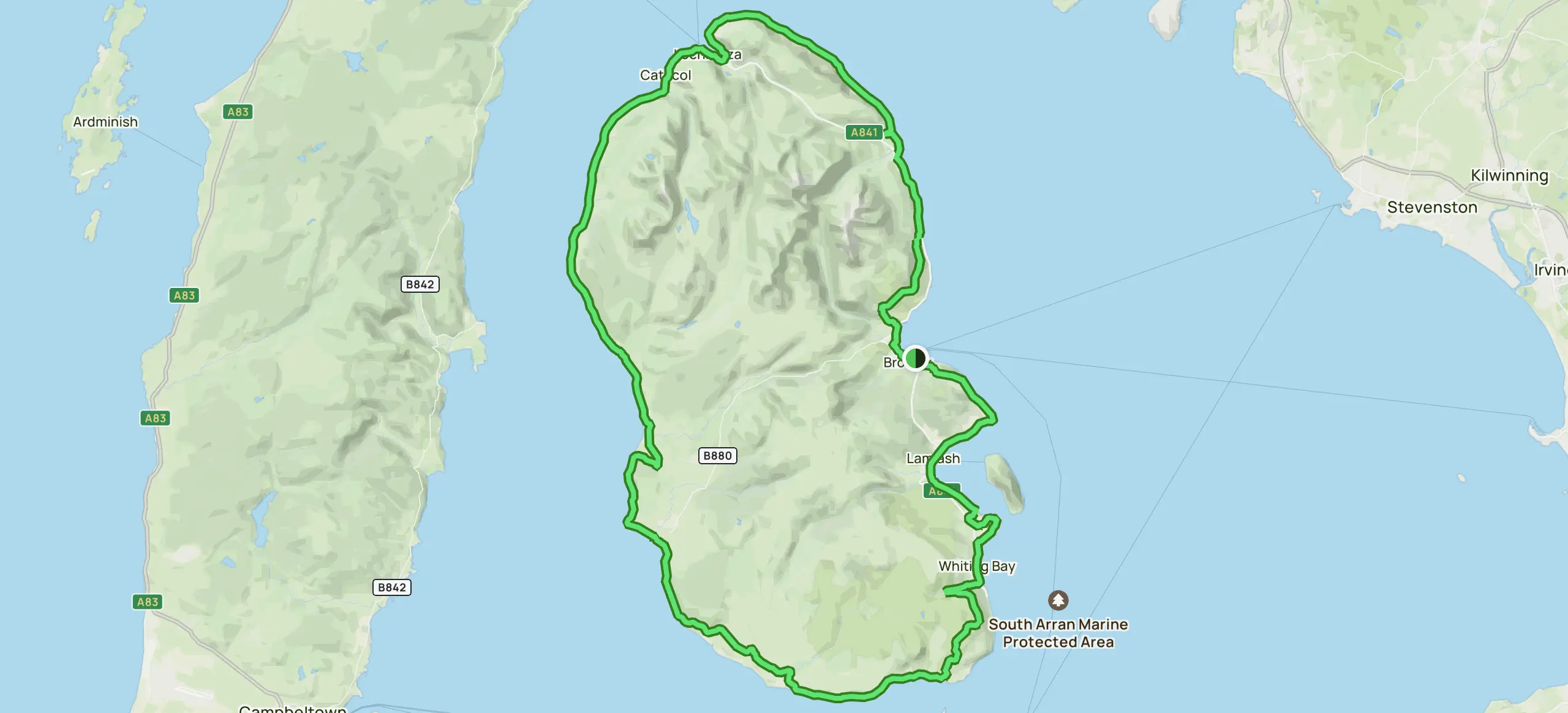
Major Roads And Routes On The Map Of Brodick Arran
Brodick Arran’s road network is simple but important for moving around the island. The main road is the A841, which runs along the east coast of the Isle of Arran. This road connects Brodick with other villages like Lamlash to the south and Lochranza to the north.
From Brodick, several smaller roads branch out to the west side of the island. These routes take you to villages such as Blackwaterfoot and Kilmory. The roads are mostly single-lane and narrow but well maintained, offering scenic views along the way.
The A841 is the key route for tourists and locals alike, as it links the ferry terminal, shops, accommodations, and important attractions. It is the best way to explore the island by car, bike, or bus.
Public transport is available along this main road, with bus services running regularly between Brodick and other parts of Arran. For those who enjoy walking or cycling, parts of the roads and trails follow beautiful coastal and hill scenery.
Overall, the road system on Brodick Arran’s map is easy to follow and connects all key places on the island efficiently.
Top Places To Visit On The Brodick Arran Map
1. Brodick Castle, Garden And Country Park
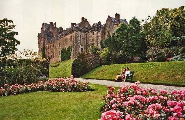
This magnificent red sandstone castle, dating from the 13th century, was the ancestral home of the Dukes of Hamilton. The castle houses an impressive collection of sporting paintings, furniture, and silver, while the gardens are renowned for their rhododendron displays.
Highlights:
- Victorian additions to medieval castle
- Formal walled garden with exotic plants
- Country park with woodland walks
- Deer park and adventure playground
Practical Information:
- Opening Hours: Daily 10:00 AM - 5:00 PM (April-October)
- Admission: Adults £15.50, Children £9.50, Family £38
- Duration: Allow 2-3 hours for full visit
- Facilities: Cafe, gift shop, toilets, parking
- Accessibility: Partial wheelchair access
Visitor Tips:
- Visit in May-June for spectacular rhododendron blooms
- Book afternoon tea in the castle restaurant
- Allow extra time for the adventure playground if visiting with children
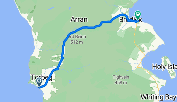
2. Goat Fell - Arran's Highest Peak
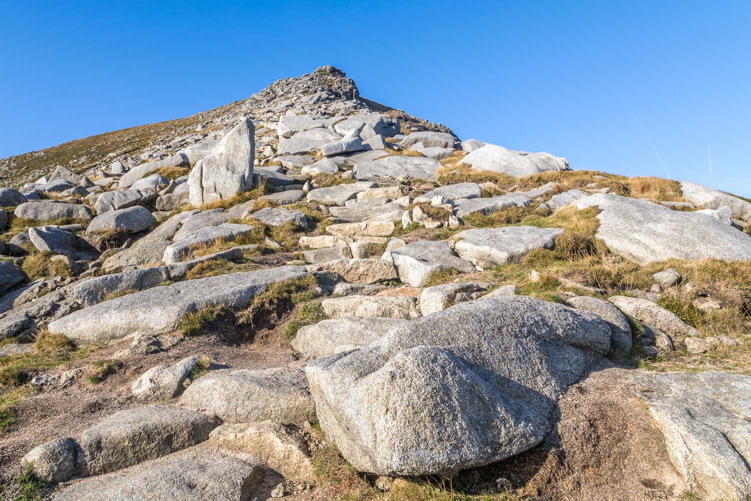
Goat Fell is the highest mountain on the Isle of Arran, standing at 874 meters (2,867 feet). It offers some of the most breathtaking views on the island. Many hikers and nature lovers come here to enjoy the walk to the summit. The climb is rewarding but requires some fitness, so maps often show resting points and different paths based on difficulty. Goat Fell is one of the unique places in scotland, offering both adventure and stunning natural beauty in one location.
Hiking Details:
- Trail Length: 5.2 miles (8.4 km) round trip
- Duration: 4-6 hours
- Difficulty: Moderate to challenging
- Elevation Gain: 874 meters
- Trail Type: Well-marked mountain path
Route Options:
- Standard Route: Via Glen Rosa, most popular, well-maintained path
- Coire na h-Uamha Route: Steeper, more challenging ascent
- Circular Route: Combining both ascent and descent routes
What to Bring:
- Sturdy hiking boots
- Weather-appropriate clothing
- Map and compass
- First aid kit
- Plenty of water and snacks
- Mobile phone (limited signal on summit)
Safety Notes:
- Check weather conditions before setting out
- Inform someone of your planned route
- Start early to allow plenty of daylight
- Mountain rescue contact: 999
3. Brodick Beach And Bay
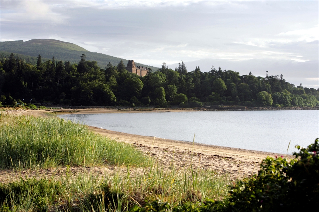
Brodick Bay is a beautiful beach area located close to the village of Brodick. It has sandy shores and calm, clear waters, making it perfect for swimming and relaxing. The bay is also a hub for water sports like kayaking and paddleboarding. Maps highlight Brodick Bay as a main attraction, showing nearby parking and picnic areas. Its gentle slopes make it family-friendly, and it is a favorite spot for visitors looking to enjoy the sea and sunshine.
Activities:
- Swimming (water temperature 12-16°C in summer)
- Kayaking and paddleboarding
- Beach walks and rock pooling
- Photography and wildlife watching
Facilities:
- Public toilets and changing rooms
- Promenade with benches
- Nearby cafes and restaurants
- Free parking along Shore Road
Wildlife Spotting:
- Seals often visible from the shore
- Various seabirds including oystercatchers and cormorants
- Occasional dolphin and porpoise sightings
4. Glen Rosa
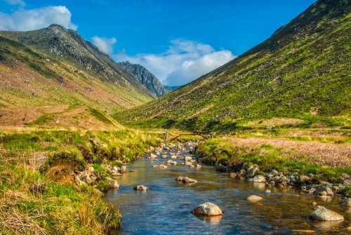
Glen Rosa is a scenic valley near Brodick, known for its peaceful walks and rich wildlife. It is surrounded by hills and forests, creating a calm natural environment. Maps mark Glen Rosa as a key walking area with trails leading into the hills or along streams. It is a popular place for spotting local birds, deer, and wildflowers. Glen Rosa is ideal for those who enjoy quiet hikes or nature photography, offering an escape from busier parts of the island.
Highlights:
- Dramatic U-shaped glacial valley
- Multiple waterfalls and mountain streams
- Gateway to Goat Fell and surrounding peaks
- Red deer and golden eagle spotting opportunities
- Ancient Caledonian pine remnants
Practical Information:
- Trail Length: 4 miles (6.4 km) to valley head
- Duration: 2-3 hours round trip
- Difficulty: Easy to moderate
- Parking: Roadside parking near Glen Rosa Farm
- Best Time: Year-round, but spring offers wildflowers
Visitor Tips:
- Excellent preparation hike for Goat Fell ascent
- Bring waterproof boots as path can be boggy
- Early morning visits offer best wildlife spotting opportunities
5. Holy Isle
Holy Isle is a small island located just off the coast near Lamlash, south of Brodick. It is famous for its special nature reserves that protect rare plants and animals. Visitors can take a short boat ride from Lamlash to Holy Isle, often shown on maps with ferry routes. The island is peaceful and offers walking trails through its woodland and along the shore. It’s a perfect spot for those interested in nature study, meditation, or simply enjoying a quiet island experience.
Highlights:
- 6th-century hermit cave of St. Molaise
- Tibetan Buddhist retreat center
- Lighthouse and dramatic cliff walks
- Rare wildlife including Eriskay ponies
- Archaeological sites dating back 1,400 years
Practical Information:
- Access: Boat from Lamlash jetty (10 minutes)
- Boat Times: April-October, weather dependent
- Cost: Adults £8, Children £4, Family £20
- Duration: Half-day or full-day visits
- Facilities: Visitor center, toilets, small shop
Visitor Tips:
- Check boat times in advance as services are weather dependent
- Respect the retreat's quiet zones and meditation areas
- Bring sturdy shoes for cliff-top walks
6. Machrie Moor Stone Circles
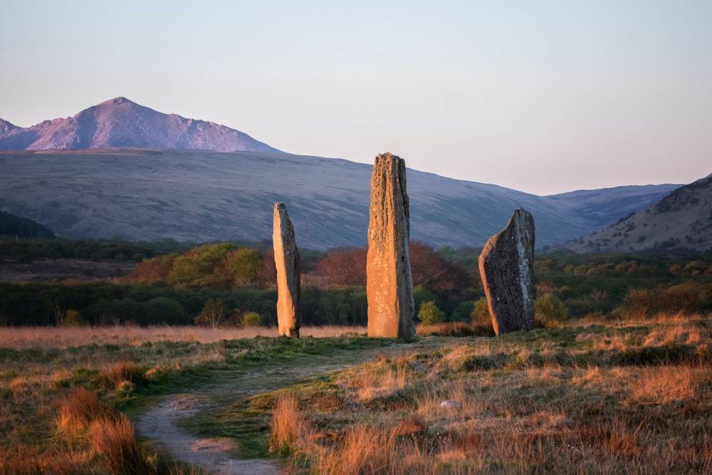
Machrie Moor Stone Circles are ancient stone circles located on the west side of the Isle of Arran. These historic monuments date back thousands of years and attract visitors interested in archaeology and history. Maps that focus on cultural and historical sites clearly mark Machrie Moor. The site includes several stone circles and standing stones set in open moorland, offering a glimpse into the island’s prehistoric past.
Highlights:
- Six stone circles within a small area
- Tall red sandstone pillars up to 5.5 meters high
- Bronze Age burial cists and standing stones
- Spectacular mountain and sea views
- Connection to Scotland's ancient ceremonial landscape
Practical Information:
- Location: 1.5 miles north of Blackwaterfoot
- Access: 20-minute walk from Machrie village
- Cost: Free admission
- Duration: 1-2 hours
- Parking: Small car park at Machrie village
Visitor Tips:
- Visit during golden hour for atmospheric photography
- Combine with King's Caves for a full day of ancient history
- Bring windproof clothing as the moor can be exposed
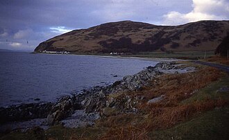
7. Lochranza Castle
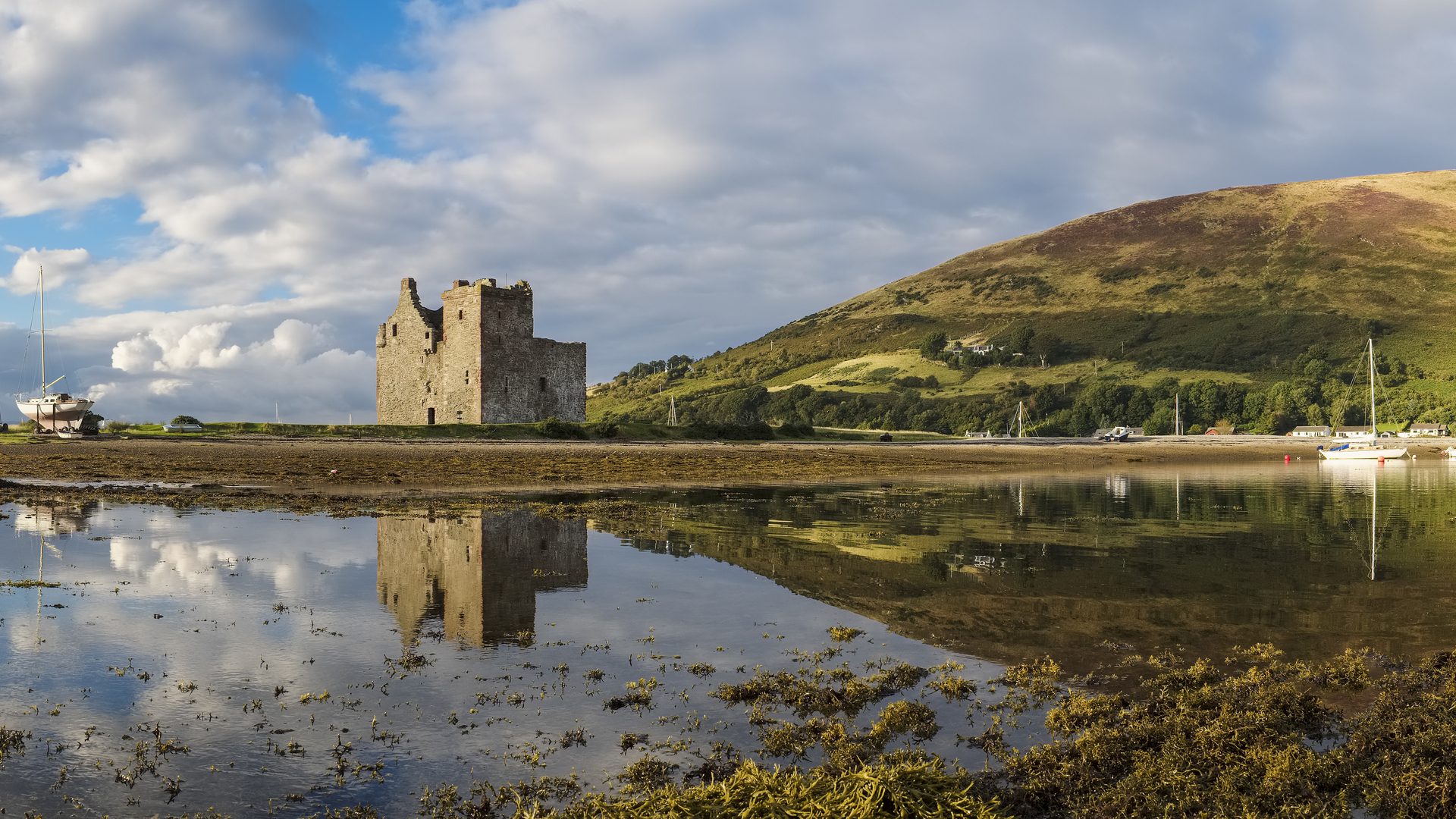
Lochranza Castle is a smaller but very scenic castle ruin located on the northern tip of Arran. It sits right on the edge of Lochranza Bay, surrounded by forests and hills. Though partly in ruins, the castle’s towers and walls still impress visitors with their strength and age. The castle dates back to the 13th century and has many stories tied to Scotland’s medieval past.
Highlights:
- Dramatic tidal location with mountain backdrop
- Well-preserved L-shaped tower house architecture
- Historical connections to Robert the Bruce
- Stunning reflections in the loch at high tide
- Red deer often graze nearby
Practical Information:
- Opening Hours: Exterior accessible year-round (daylight hours)
- Admission: Free (exterior viewing)
- Duration: 30-45 minutes
- Parking: Free parking in Lochranza village
- Accessibility: Accessible viewing from road and shore
Visitor Tips:
- Best photographed at high tide for dramatic reflections
- Combine with Arran Distillery visit (5-minute walk)
- Early morning visits often feature red deer sightings
8. King’s Caves
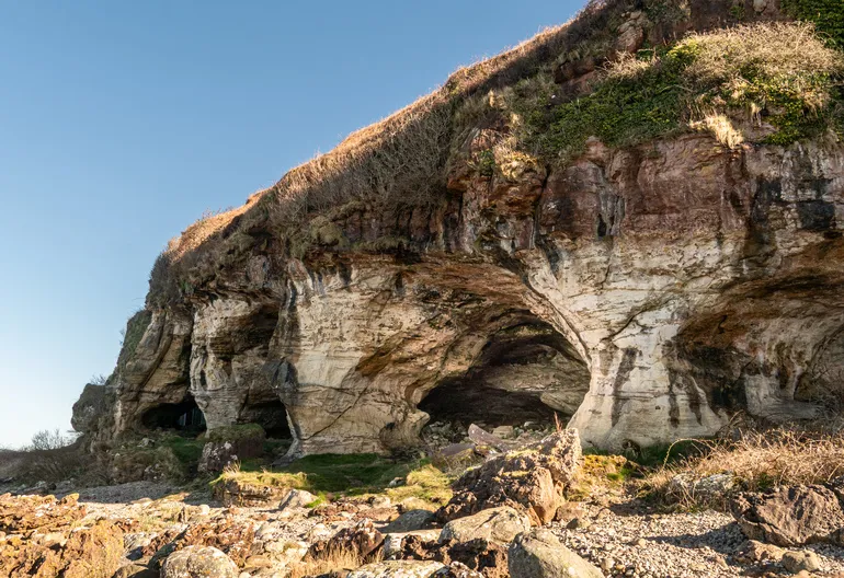
King’s Caves are a group of sea caves located on the southwest coast of Arran, near Blackwaterfoot village. These caves are famous for their connection to Robert the Bruce, a Scottish king who is said to have hidden here during his fight for Scotland’s freedom. The caves are carved into the cliffs by the sea and can be explored when the tide is low. Highlights:
- Seven interconnected sea caves
- Ancient rock art and Christian symbols
- Robert the Bruce historical connections
- Spectacular coastal cliff scenery
- Accessible at low tide for full exploration
Practical Information:
- Location: 2 miles north of Blackwaterfoot
- Access: 30-minute coastal walk from Blackwaterfoot
- Best Time: 2 hours either side of low tide
- Duration: 2-3 hours including walk and exploration
- Facilities: None - bring supplies
Visitor Tips:
- Check tide times before visiting - caves partially flooded at high tide
- Bring torch/headlamp for cave exploration
- Wear good grip shoes as rocks can be slippery
9. Arran Distillery
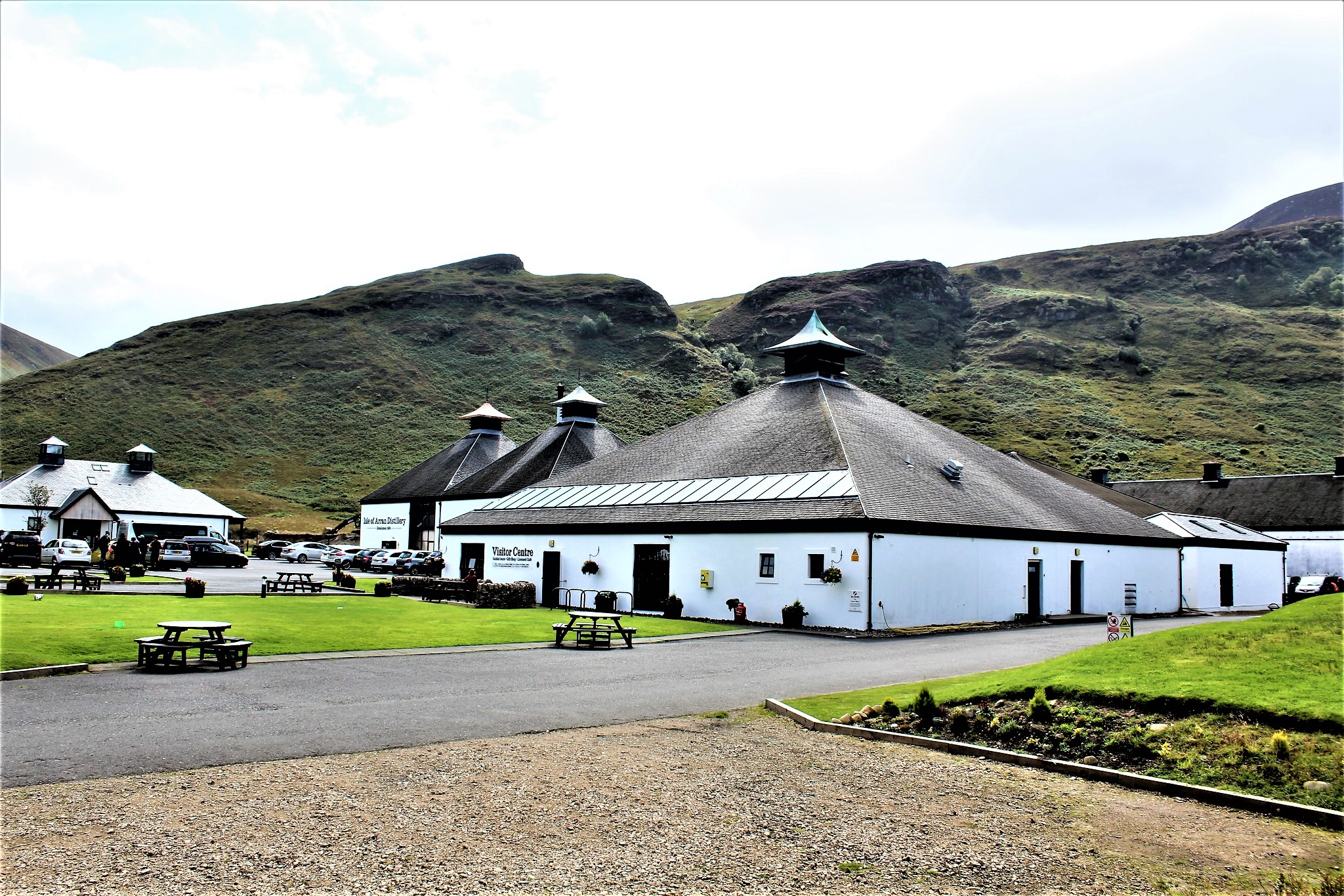
The Arran Distillery is in Lochranza village and is a great place to learn about whisky-making, a famous Scottish tradition. Visitors can take guided tours to see how whisky is made from barley to bottling. The distillery also has a shop where you can taste and buy different types of Arran whisky. It’s a fun and educational stop, especially for adults interested in Scotland’s cultural drinks.
Highlights:
- Interactive guided distillery tours
- Whisky tastings with expert guidance
- Visitor center with extensive whisky shop
- Beautiful mountain and loch location
- Limited edition and exclusive bottlings
Practical Information:
- Opening Hours: Daily 10:00 AM - 5:00 PM (March-October)
- Tours: 10:30 AM, 12:30 PM, 2:30 PM, 4:00 PM
- Cost: Standard tour £10, Premium tour £20
- Duration: Tours last 45 minutes plus tasting
- Facilities: Cafe, shop, toilets, parking
Visitor Tips:
- Book tours in advance during summer months
- Try the 18-year-old for a premium island whisky experience
- Combine with visit to nearby Lochranza Castle
10. Torr Darach
Torr Darach is a beautiful rocky hill found on the west side of the island near the village of Shiskine. It offers easy walking trails and great views of the surrounding countryside and sea. The hill is covered in green grass and wildflowers in spring and summer, making it a lovely spot for nature walks, bird watching, and photography. Torr Darach is less crowded than other areas, so it’s perfect for visitors looking for peace.
Highlights:
- Panoramic views across the Firth of Clyde
- Relatively easy climb suitable for families
- Wildflower meadows in spring and summer
- Quiet alternative to busier mountain walks
- Excellent photography opportunities
Practical Information:
- Trail Length: 2 miles (3.2 km) round trip
- Duration: 1.5-2 hours
- Difficulty: Easy to moderate
- Starting Point: Shiskine village
- Parking: Limited roadside parking in Shiskine
Visitor Tips:
- Visit on clear days for views to Ireland and Kintyre
- Spring visits offer excellent wildflower displays
- Combine with exploration of Shiskine Valley
11. Catacol Bay
Catacol Bayis a small, charming bay on the northwestern coast of Arran. It is known for its old fishermen’s cottages, which were once homes to local fishermen and are now part of a historic village. The bay is calm and surrounded by hills and cliffs. It’s a nice place for walking, exploring nature, and enjoying beautiful sunsets over the water. Catacol has a quiet, old-fashioned feel that gives visitors a sense of how island life was many years ago.
Highlights:
- Historic "Twelve Apostles" cottages
- Sweeping sandy beach and clear waters
- Dramatic mountain backdrop including Caisteal Abhail
- Peaceful setting away from main tourist routes
- Excellent sunset viewpoint
Practical Information:
- Location: 8 miles north of Blackwaterfoot
- Access: Via coastal road (A841)
- Facilities: Limited - small car park only
- Duration: 1-2 hours for beach walk and exploration
- Best Time: Late afternoon for optimal lighting
Visitor Tips:
- Excellent location for sunset photography
- Combine with visit to nearby Lochranza
- Bring picnic as no facilities available
12. Shiskine Valley

Shiskine Valley is a peaceful area in the south of the island with farms, forests, and walking paths. It is famous for its lovely green fields, fruit orchards, and friendly local farms. Visitors can enjoy easy walks, meet farm animals, and buy fresh local produce like berries and honey. Shiskine Valley is ideal for families and those who want to see the rural side of Arran, away from the busier towns.
Highlights:
- Traditional Scottish farming landscape
- Ancient oak woodlands and wildlife habitats
- Stone circles and archaeological sites
- Local farm shops and producers
- Network of quiet country lanes perfect for cycling
Practical Information:
- Location: Central-southern Arran, inland from Blackwaterfoot
- Access: Multiple entry points from A841
- Walking Trails: Various lengths from 1-4 miles
- Duration: Half-day to full-day exploration
- Facilities: Local shops and cafes in nearby villages
Visitor Tips:
- Visit local farm shops for artisan produce and crafts
- Spring and early summer best for wildlife and wildflowers
- Excellent area for family cycling on quiet country roads
How To Use A Map Of Brodick Arran For Travel
Using a map of Brodick Arran can make traveling around the island easier and more enjoyable. Here are some tips:
- Plan Your Route: Look for roads, trails, and ferry points. The A841 road circles the island, so you can plan to visit different villages and natural spots.
- Check Distances: Maps help you see how far places are from each other. This helps if you want to walk, cycle, or drive.
- Find Key Places: Use the map to locate shops, hotels, restaurants, and attractions like Brodick Castle or beaches.
- Use Different Maps: Tourist maps are good for finding sights and trails. Road maps help with driving. Topographic maps are useful for hiking.
- Look for Public Transport: Bus stops and ferry terminals are usually marked, so you can use public transport if you don’t have a car.
- Safety First: If hiking, use a detailed map that shows elevation and paths to avoid getting lost.
A good map helps you enjoy Brodick and Arran fully, making sure you see all the best places with ease.
People Also Ask
How Can I Get To Brodick Arran?
The main way to reach Brodick is by taking a ferry from the Scottish mainland. The ferry arrives at Brodick Pier, which is the island’s main transport hub.
What's The Best Viewpoint In Brodick?
Goat Fell summit offers the best panoramic views, but for easier access, try the viewpoint at Glen Rosa or the upper paths in Brodick Castle Country Park.
Is Brodick Suitable For Families With Young Children?
Absolutely! Brodick offers family-friendly beaches, easy walking trails, and attractions like Brodick Castle's adventure playground. Many restaurants have children's menus.
Do Local Maps Show Bus Routes And Transport Links?
Most tourist maps include transport information like bus routes, ferry ports, and taxi stands, especially around Brodick where public transport is most active.
Is It Easy To Navigate Brodick On Foot Using A Map?
Yes, Brodick is compact and well-signposted. A basic tourist map is usually enough for walking around the village and accessing nearby sites. For longer hikes, a more detailed map is recommended.
Final Thoughts
Using a clear map of Brodick and Arran can turn a good trip into a great one. Maps make it easier to plan your route, visit special places, and enjoy each part of the journey without getting lost.
Keep a map nearby on your phone or in your backpack to enjoy the coastlines, trails, and sights that make Arran unforgettable. Every path holds a story, and the right map helps you follow it with ease.
Jump to
Your Handy Map Of Brodick Arran For Landmarks, Walks & Travel Info
Quick Facts About Brodick, Arran
Getting To Brodick: Ferry Information & Transport
Planning Your Visit To Brodick
Geographical Overview Of Brodick, Arran
Capital Of Brodick, Arran
Villages And Towns On The Map Of Brodick Arran
Regions On The Map Of Brodick Arran
Population Of Brodick Arran
Currency Of Brodick Arran
Dialing Code Of Brodick Arran
Language Of Brodick Arran
Flag Of Brodick Arran
Government Of Brodick Arran
Total Area Of Brodick Arran
Types Of Brodick Arran Map
Major Roads And Routes On The Map Of Brodick Arran
Top Places To Visit On The Brodick Arran Map
How To Use A Map Of Brodick Arran For Travel
People Also Ask
Final Thoughts

Callum Fraser
Author
Callum Fraser isn't just a writer about Scotland; he's a product of its rugged landscape and rich history. Born and raised in Perthshire, with the Highlands as his backyard, his love for the nation's stories was kindled by local storytellers and long walks through ancient glens.
This passion led him to pursue a degree in Scottish History from the University of Edinburgh. For over 15 years, Callum has dedicated himself to exploring and documenting his homeland, fusing his academic knowledge with essential, on-the-ground experience gained from charting road trips through the Cairngorms, hiking the misty Cuillins of Skye, and uncovering the secrets of traditional recipes in his family's kitchen.
As the Editor-in-Chief and Lead Author for Scotland's Enchanting Kingdom, Callum's mission is simple: to be your most trusted guide. He combines meticulous research with a storyteller's heart to help you discover the authentic magic of Scotland — from its best-kept travel secrets to its most cherished traditional recipes.
Latest Articles
Popular Articles