Portree Isle Of Skye Map - Roads, Landmarks & Walking Paths
Use the Portree Isle of Skye map to find roads, scenic paths, and landmarks. Plan your route easily around Skye’s central town.
Author:Callum FraserJun 26, 202515.3K Shares478.6K Views
Portree sits at the heart of the Isle of Skye; not just geographically, but in daily life, travel, and local culture. It’s where many journeys begin and where road maps, walking routes, and travel plans converge.
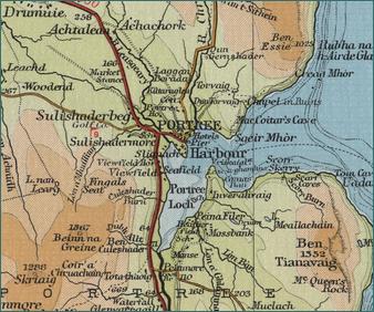
Looking closely at the Portree Isle of Skye mapreveals more than place names and streets; it shows how this small town connects visitors to cliffs, coastlines, villages, and viewpoints across the island.
Quick Facts About Portree, Isle Of Skye
- Location: East coast of the Isle of Skye, Scotland
- Population: Around 2,500 people
- Language: English is widely spoken; some residents speak Scottish Gaelic
- Main Features: Colourful harbour, hills, and sea views
- Transport Links: Connected by the A87 road; nearest major town is Kyle of Lochalsh
- Name Meaning: "Portree" means "King’s Port" in Gaelic
- Tourism Role: Main base for visitors exploring the Isle of Skye
- Nearby Attractions: Old Man of Storr, Quiraing, Fairy Pools, and Raasay Island
- Facilities: Shops, hotels, restaurants, fuel station, and visitor information centre
- Walking Trails: Popular routes include Scorrybreac Circuit and The Lump
- Climate: Mild, wet, and windy dress for changing weather
- Famous For: Scenic harbour, local seafood, and easy access to Skye's top sights
Geographical Overview Of Portree, Isle Of Skye
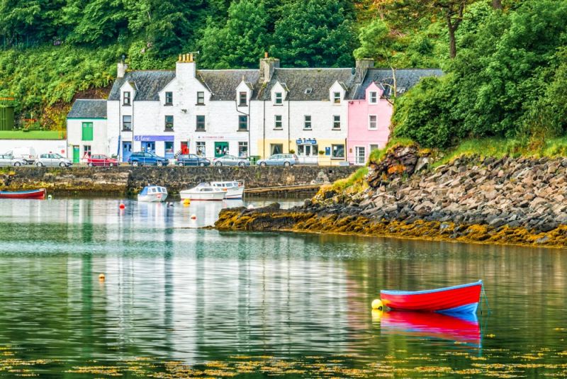
Portree is on the east coast of the Isle of Skye, facing the Sound of Raasay. The town sits by a sheltered bay and is surrounded by hills, cliffs, and forests. Its natural harbour makes it one of the most attractive spots in northern Scotland.
The town rises from the harbour into higher ground, with narrow streets, walking paths, and scenic viewpoints like The Lump. North of Portree, the land becomes more rugged, leading to well-known places like the Old Man of Storr and The Quiraing.
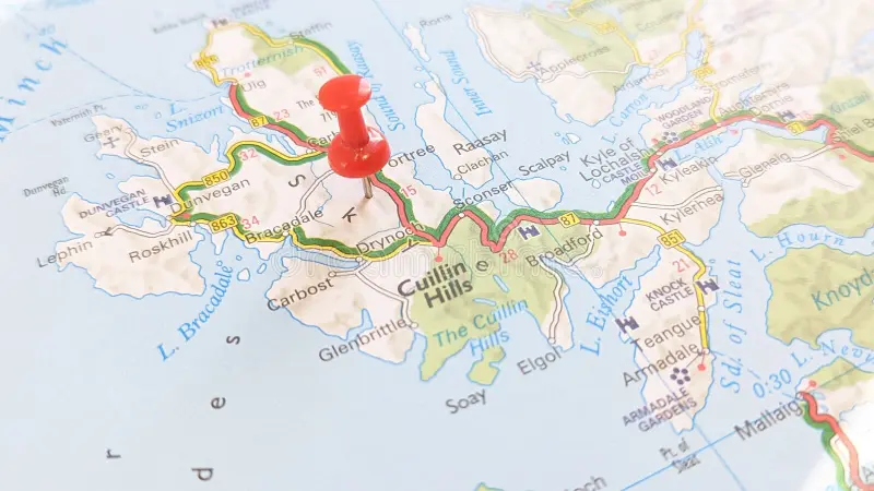
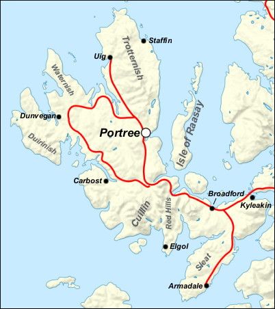
Portree is linked by the A87 road, making it easy to reach from the Skye Bridge and other parts of the island. Its central location and varied landscape make it a useful base for exploring both the east and west sides of Skye.
History Of Portree, Isle Of Skye
Portree’s history dates back many centuries, though the town we know today began to grow in the early 1700s. Its name comes from the Gaelic "Port Rìgh," meaning "King’s Port," said to be named after a visit by King James V of Scotland in 1540. He came to the island to meet local clan leaders and strengthen royal control over the Highlands and islands.
The natural harbour made Portree an important fishing village and safe anchorage point. By the 18th and 19th centuries, it became a busy port for trade, connecting Skye with the mainland. Fishing, farming, and crofting were the main ways people made a living. During this time, the town expanded with the addition of a pier, roads, and new buildings.
Portree also played a role in Scotland’s clan history. It was a stronghold of the MacDonald and MacLeod clans, and nearby areas saw conflict during the Jacobite uprisings. The town’s Gaelic culture remained strong, especially through language, music, and local traditions.
In modern times, Portree has become the main town and administrative centre of Skye. It supports tourism, education, local government, and island services, while still keeping its historical charm and strong Highland identity.
Administrative Centre On The Map Of Portree, Isle Of Skye
Portree is the main town and administrative centre of the Isle of Skye. On any detailed map of the island, Portree is usually shown near the centre of the east coast. It plays an important role in local government, transport, and public services.
What You’ll Find In The Administrative Centre:
- Highland Council Offices:Local government services for Skye are based here
- Schools:Including Portree High School and the local primary school
- Health Services:Portree has a hospital and a medical centre
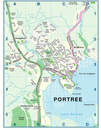
- Transport Hub:The town centre has a main bus stop in Somerled Square, shown on most town maps
- Post Office and Banking Services:Found around the square and nearby streets
- Police and Fire Services:Marked on local maps and useful in case of emergency
The administrative area is based around Somerled Square and nearby roads like Home Farm Road and Fingal Road. This part of Portree is easy to reach on foot from the harbour or residential areas, and it's well-marked on maps used by visitors and locals.
Because of its central role, most travellers use Portree as their base when staying on Skye. Maps often highlight this area first, showing essential services and how to connect to other parts of the island.
Town And Villages On The Map Of Portree, Isle Of Skye
Portree is the main town on the Isle of Skye, and it is surrounded by small villages that are easy to find on local and regional maps. These places are often linked by quiet roads, and many are close to famous sights.
Portree
Portree is the largest town on Skye and the centre for transport, shops, and public services. It has a busy harbour, a town square, schools, and a hospital. Most maps of Skye place Portree in the middle or highlight it clearly. Many people stay here when visiting the island because it’s close to many attractions.
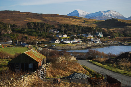
Staffin
Staffin is a small village about 17 miles north of Portree. It’s known for beautiful sea views, cliffs, and the famous Old Man of Storr and Quiraing nearby. Maps often show Staffin as part of the Trotternish Peninsula. It’s a good spot for hiking and seeing dinosaur footprints on the beach.
Uig
Uig is located around 15 miles northwest of Portree. It’s a quiet village with a ferry port that connects Skye to the Outer Hebrides. On most maps, Uig is shown as a transport hub and is easy to reach by road. It’s also known for craft shops, waterfalls, and nearby walking trails.
Broadford
Broadford is the second-largest settlement on the Isle of Skye. It’s about 25 miles south of Portree and is often the first town visitors see after crossing the Skye Bridge. Maps show it as a main stop with shops, fuel stations, and sea views. It’s a useful place for supplies before heading further into Skye.
Dunvegan
Dunvegan lies around 22 miles west of Portree and is best known for Dunvegan Castle, the oldest continuously inhabited castle in Scotland. Maps show it near the western coast. The village has places to eat, stay, and walk along the loch. It’s a great day trip from Portree.
Sconser
Sconser is a small village between Portree and Broadford. It’s marked on maps because it has the ferry terminal to the Isle of Raasay. The area is quiet, with views across the water and small walking paths. It’s a good stop if you plan to visit Raasay.
Edinbane
Edinbane is west of Portree and is often marked on maps as a resting point between the town and Dunvegan. It’s a peaceful village with traditional inns, craft galleries, and woodland walks. Many tourists pass through it while exploring the island by car.
Regions On The Map Of Portree, Isle Of Skye
Portree may be small, but it has several areas that show up on local maps. Each one has its own use and feel. Below are the main regions you’ll find in and around Portree:
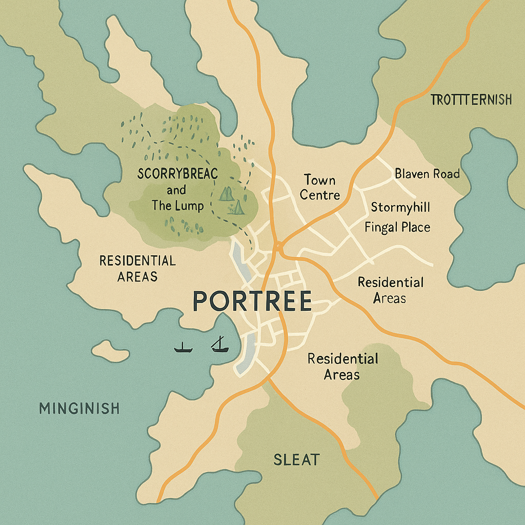
Harbour Area
This is the most well-known part of Portree. The harbour sits at sea level and is where fishing boats, tour boats, and local cruises dock. It’s lined with colourful buildings and seafood restaurants. The harbour area is often busy in summer and is a great place to take photos or book a boat trip. It’s usually marked near Bosville Terrace and the pier on a map.
Town Centre
The centre of Portree is built around Somerled Square, where you’ll find shops, cafes, banks, and the main bus stop. This area is easy to spot on a map because it connects to key roads like Wentworth Street and Bank Street. It’s also home to the tourist information centre and is often where walking tours begin. Most visitors spend time here for shopping, dining, or planning day trips.
Scorrybreac And The Lump
These are green spaces on the edge of town, perfect for walking and relaxing. Scorrybreac is a circular trail that offers views over the bay and across to the Isle of Raasay. The Lump is a small wooded hill with a viewing tower at the top. These spots are shown on walking maps and are popular for short hikes and peaceful walks. They are close to the harbour and offer great photo opportunities.
Residential Areas
Portree has several small neighbourhoods where most local people live. Common ones shown on maps include:
- Blaven Road
- Stormyhill
- Fingal Place
These areas are spread out on the hills around the town centre. They have houses, schools, and quiet streets. Visitors may pass through them when staying at guest houses or using back roads.
Trotternish Peninsula, Minginish, And Sleat
These are larger regions outside of Portree but often shown on Isle of Skye maps.
- Trotternish Peninsula lies to the north and includes famous places like the Old Man of Storr and Quiraing.
- Minginish is to the west and includes Glen Brittle and the Cuillin mountains.
- Sleat is in the south and is known for its woodlands, ferry ports, and Gaelic culture.
These regions are used more to describe parts of the landscape, not towns or city districts. They help visitors plan which direction to travel when using a Skye map.
Population Of Portree, Isle Of Skye
The population of Portree is around 2,500 people. It’s the most populated place on the Isle of Skye. While small in size, Portree sees many more people during peak tourist seasons, when visitors from around the world come to explore the island and use Portree as their base.
Currency Of Portree, Isle Of Skye
The official currency used in Portree, as in the rest of Scotland and the UK, is the British Pound Sterling (GBP). Both English and Scottish banknotes are accepted in shops, restaurants, and hotels across Portree.
Dialing Code Of Portree, Isle Of Skye
The telephone dialing code for Portree is +44 (0)1478 when calling from outside the UK. When calling locally within the UK, simply use 01478 followed by the local number.
Language Of Portree, Isle Of Skye
The main language spoken in Portree is English. However, Scottish Gaelicis also used and holds cultural importance. You may see bilingual road signs and hear Gaelic spoken, especially in schools and community events.
Government Of Portree, Isle Of Skye
Portree is governed as part of the Highland Council area, which manages local services like schools, roads, housing, and tourism. It has no separate mayor or town council, but it serves as the administrative centre for Skye within the Highland region.
Total Area Of Portree, Isle Of Skye
Portree covers a small area of approximately 3 to 4 square kilometres (1.2 to 1.5 square miles). It includes the harbour, town centre, surrounding residential areas, and nearby hills such as The Lump.
Types Of Portree, Isle Of Skye Map
There are different types of maps available to help you navigate Portree and its surroundings:
- Road Maps:Show main roads, driving routes, fuel stops, and car parks
- Walking Maps:Highlight footpaths, trails like Scorrybreac, and viewpoints
- Topographic Maps:Display land elevation, terrain, and hiking details (e.g., OS Explorer Map 408)
- Tourist Maps:Mark attractions, accommodations, restaurants, and public services
- Digital Maps:Available on apps like Google Maps, Komoot, OS Maps, and ViewRanger
Each type of map helps travellers explore Portree safely and more efficiently, depending on how they are getting around.
Driving Routes And Transportation In Portree, Isle Of Skye
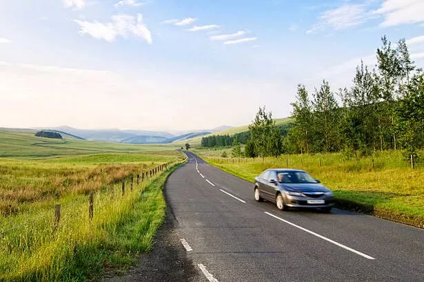
Getting to and around Portree is easy if you understand the main roads and transport options. Portree is well connected to other towns and villages on the Isle of Skye by a small but reliable network of roads. It also has public transport services, though they are limited compared to larger cities.
Main Driving Routes To Portree
- A87 Road -This is the main road that connects Portree to the Skye Bridge and the Scottish mainland. It also links Portree to Broadford (south) and Uig (northwest).
- A855 Road- This scenic road runs north from Portree along the coast to Staffin and the Trotternish Peninsula. It’s a popular route for visiting the Old Man of Storr, Kilt Rock, and the Quiraing.
- A850 Road- This road runs west from Portree towards Edinbane and Dunvegan, passing through quiet moorland and crofting communities.
Road signs are in English and Gaelic, and roads are generally single carriageways with passing places. A good road map or GPS is useful, especially when exploring rural areas.
Public Transportation In Portree
- Bus Services- Portree has a main bus stop at Somerled Square. Regular buses run to and from Broadford, Kyle of Lochalsh, Uig, and other villages. Bus services are operated by Stagecoach Highlandsand local providers. Timetables can vary, especially on weekends.
- Taxi Services- Taxis are available in Portree, but it's best to book ahead, especially in summer or in the evenings.
- Tour Buses- Several private companies run guided bus tours that start from Portree and visit major sights around Skye. These tours are ideal for visitors without a car.
- Car Rentals- Cars can be hired from nearby towns such as Broadford or Kyle of Lochalsh. Booking in advance is recommended.
Parking In Portree
There are several car parks around the town, including:
- Bayfield Car Park- The largest public parking area, close to the harbour
- Somerled Square Car Park- Near the town centre
- Harbourfront Parking- Limited spaces, mostly short stay
Parking is usually free but may have time limits. During the busy season, it’s best to arrive early to find a space.
Tips For Drivers And Travellers
- Drive on the left side of the road (UK standard)
- Use passing places on single-track roads to let others pass
- Watch for sheep and wildlife on rural roads
- Fuel up in Portree or Broadford, petrol stations are few outside the towns
- Mobile signal can be weak in remote areas, download maps in advance if using a phone for navigation
Walking Routes On The Portree Isle Of Skye Map
Walking is one of the best ways to experience Portree and the surrounding landscape. Local maps of Portree show a mix of short town walks, coastal paths, and hill routes. These paths offer quiet views, natural scenery, and a close look at the area's geography and culture.
Scorrybreac Trail
The Scorrybreac Trail is the most popular local walk in Portree. It begins near the harbour and follows a circular path through woods, coastal cliffs, and open viewpoints. The route is well-marked and takes about 45 minutes to 1 hour to complete.
- Distance: ~2.5 km (1.5 miles)
- Terrain: Mixed woodland, cliff edge, and grass paths
- Viewpoints: Isle of Raasay, Portree Bay, The Lump
- Map Tip: Marked on local walking maps and Ordnance Survey Explorer 408
The Lump Path
The Lump is a grassy hill near the centre of Portree. A short path leads to the top, where you’ll find a small tower and excellent views of the harbour and nearby hills. It’s often used for local events, including the Skye Highland Games.
- Distance: ~0.5 km
- Terrain: Steep grassy slope with paved sections
- Viewpoints: Portree Harbour, Cuillin Hills in the distance
- Map Tip: Found on town maps and tourist information signs
Ben Tianavaig Trail
Just south of Portree, Ben Tianavaig offers a quieter hill walk with sweeping views over the Sound of Raasay. It's a longer and more challenging walk compared to the town trails.
- Distance: ~6 km return (3.7 miles)
- Terrain: Steep grassy slope, uneven in parts
- Highlights: Wildlife sightings (eagles, deer), sea views, remote feel
- Map Tip: Marked on regional and hiking-specific maps
The Old Man Of Storr (Near Portree)
Although not directly in Portree, this famous walk is just a 15-minute drive north and is often included in local walking plans. The path climbs to one of Scotland’s most iconic rock formations and offers dramatic views over Skye’s landscape.
- Distance: ~3.8 km return (2.4 miles)
- Terrain: Gravel paths, steady uphill climb
- Highlights: Rock pinnacles, mountain and sea views
- Map Tip: Clearly marked on Skye walking maps and signposted at the parking area
Portree To Camastianavaig Coastal Walk
This lesser-known route follows the coast from Portree to the small settlement of Camastianavaig. It’s longer and more rugged but provides peaceful surroundings and views of the sea and cliffs.
- Distance: ~9 km (one way)
- Terrain: Rough tracks, shoreline, and moorland
- Best For: Experienced walkers looking for a quiet route
- Map Tip: Shown on detailed Ordnance Survey maps and local walking guides
Tips For Walking In And Around Portree
- Use a local walking map: The Ordnance Survey Explorer 408 map covers the Portree area in detail.
- Wear proper footwear: Some paths are uneven or muddy, especially after rain.
- Check the weather: Conditions can change quickly on Skye bring waterproofs and layers.
- Stay on marked routes: Paths cross private and open land; respect signs and fences.
National Scenic Areas On The Portree, Isle Of Skye Map
While the Isle of Skye does not have any official national parks, it features several National Scenic Areas (NSAs)protected parts of Scotland known for outstanding natural beauty. These areas are important for tourism, conservation, and cultural heritage.
Trotternish National Scenic Area
The Trotternish NSA is the main National Scenic Area near Portree and covers a large part of the Trotternish Peninsula, which stretches north of the town. This area includes:
- The Old Man of Storr:A famous rock spire and hiking spot, about 7 miles from Portree
- The Quiraing:A dramatic landslip with walking trails and unusual rock shapes
- Staffin Bay:Coastal views, waterfalls, and places where dinosaur footprints have been found
- Kilt Rock and Mealt Falls:A cliff that looks like a kilt, with a waterfall dropping into the sea
These places are all part of the protected Trotternish landscape and are marked on detailed maps as part of the NSA zone. You’ll often see this label on Ordnance Survey maps or tourist walking guides.
Why These Areas Are Protected
The National Scenic Areas around Portree are protected to:
- Preserve natural landforms, wildlife, and coastlines
- Support responsible tourism and hiking
- Protect Gaelic cultural heritage and archaeological sites
- Allow traditional farming and crofting to continue alongside nature
Because of their status, you won’t find major developments or big roads through these areas, which helps keep the landscape peaceful and natural.
Tourist Attractions On The Portree, Isle Of Skye Map
Portree and the surrounding areas are full of beautiful places to visit. These attractions are marked on tourist maps and are popular with visitors from all over the world. Here’s a guide to some of the top spots you’ll see on the map.
Portree Harbour
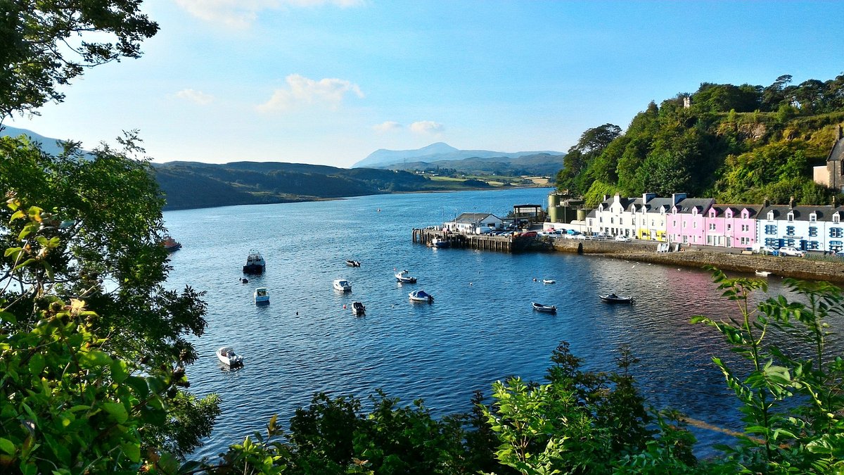
This is one of the most famous views in Skye. The harbour is lined with colourful buildings and fishing boats. It’s a peaceful place to sit, take photos, and enjoy seafood at a local restaurant. Boat tours also leave from here, and many walking trails start nearby.
Somerled Square
This is the main town square in Portree. It’s where you’ll find shops, buses, banks, cafes, and the local tourist information centre. It’s a great place to start your visit and is shown clearly on all town maps.
Old Man Of Storr
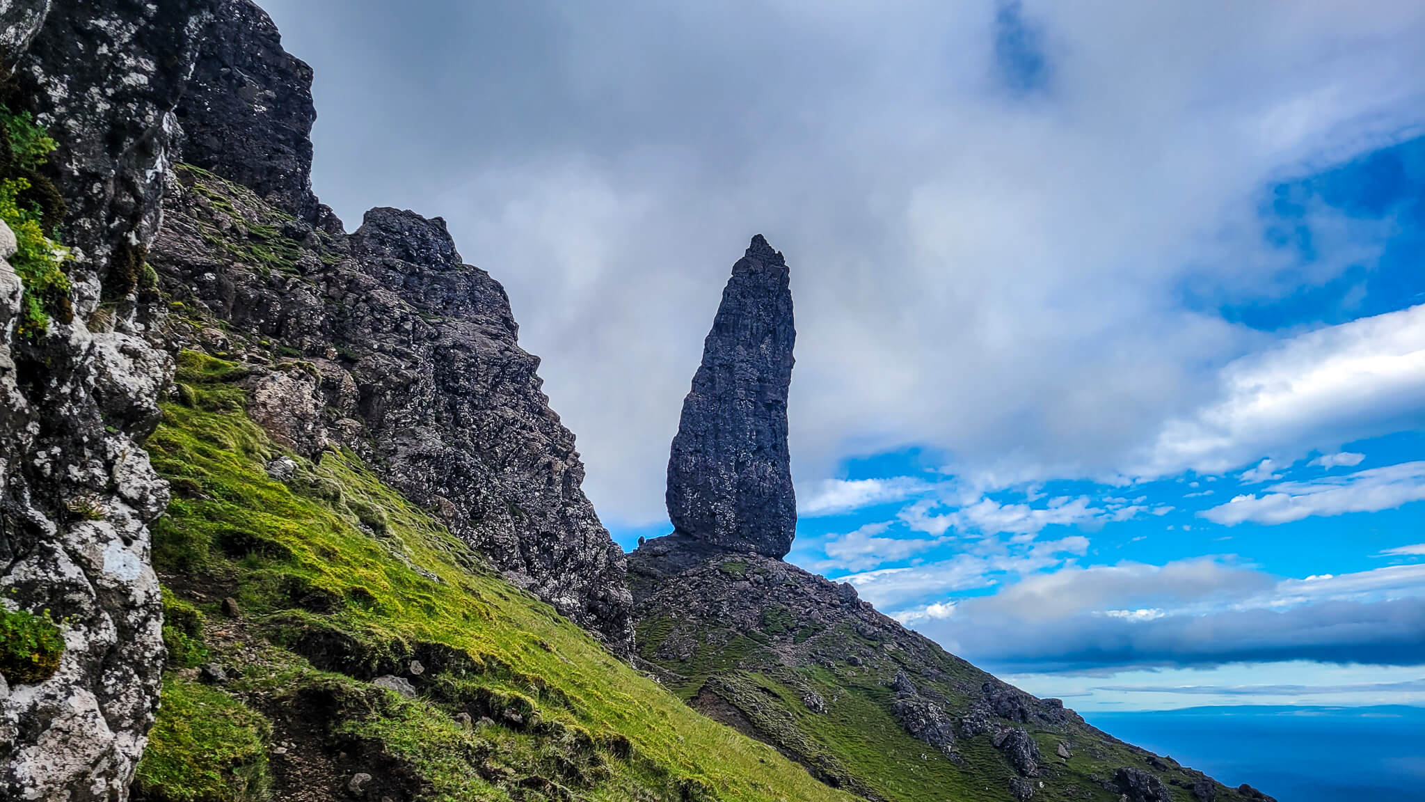
One of the most famous landmarks on Skye. It’s a tall, rocky hill with a pointed rock standing up from the slope. The trail to reach it is about 15 minutes by car from Portree, and the hike takes 1 to 2 hours. It’s always marked on Isle of Skye maps because it’s such a popular spot.
The Quiraing
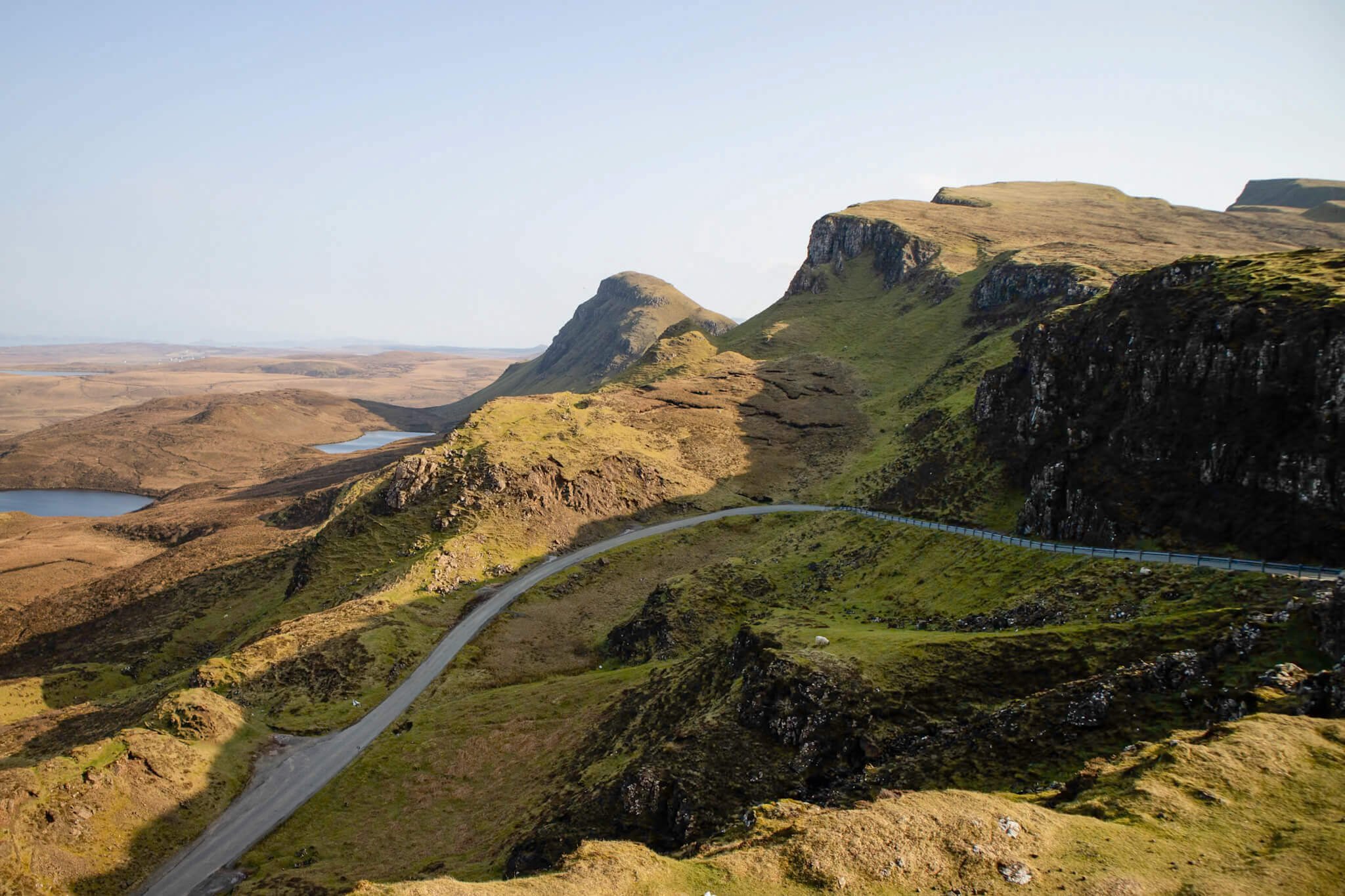
A dramatic landslip in the Trotternish Ridge, north of Portree. The landscape looks like something from a movie, with cliffs, rock towers, and green slopes. There’s a walking route here that takes about 2 to 3 hours. It’s easy to find on most regional maps of Skye.
Kilt Rock And Mealt Falls
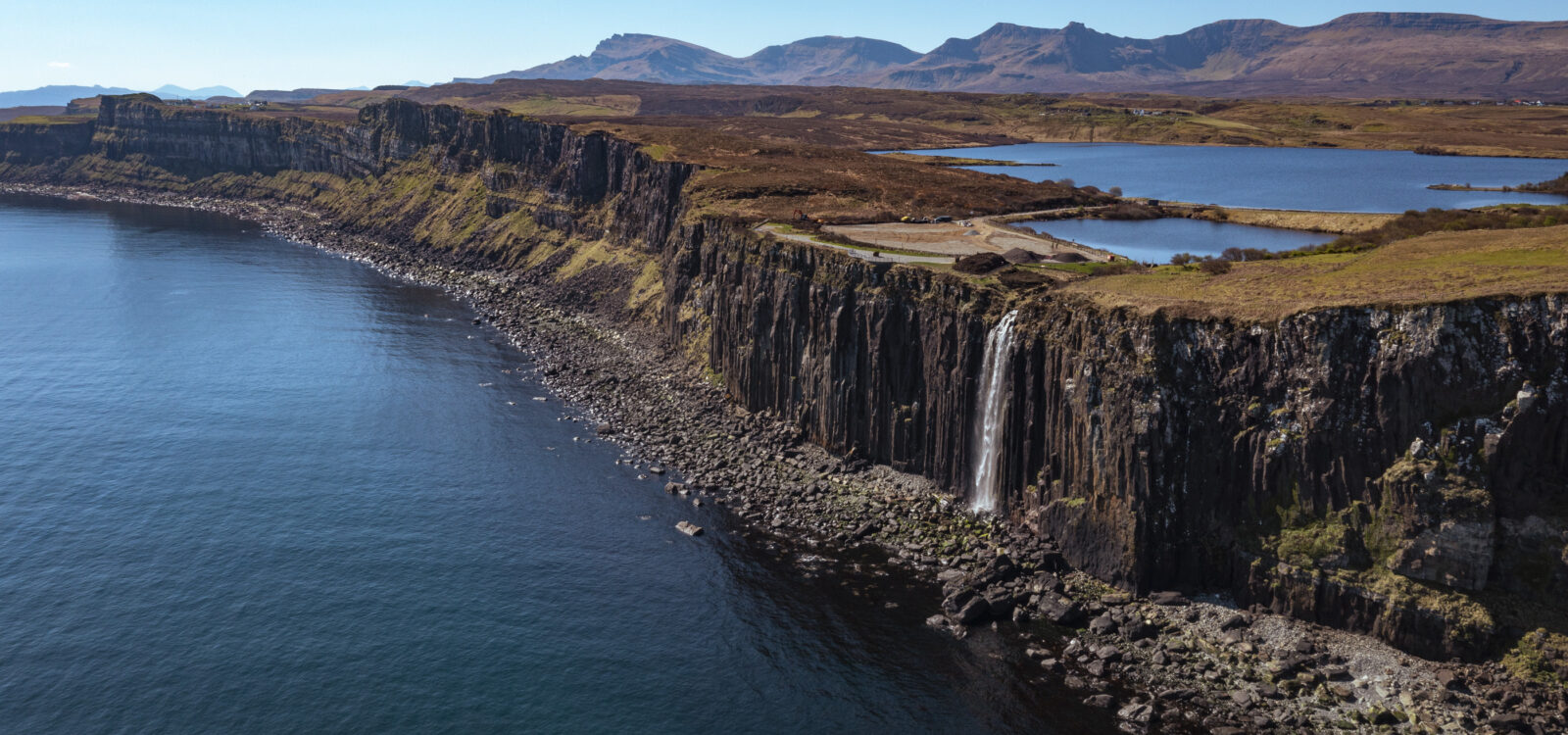
This cliff looks like a pleated kilt, and a waterfall (Mealt Falls) drops straight into the sea. There is a viewing platform just off the road, not far from Staffin. It’s a quick stop, and many tourist maps mark it clearly as a viewpoint.
Fairy Glen
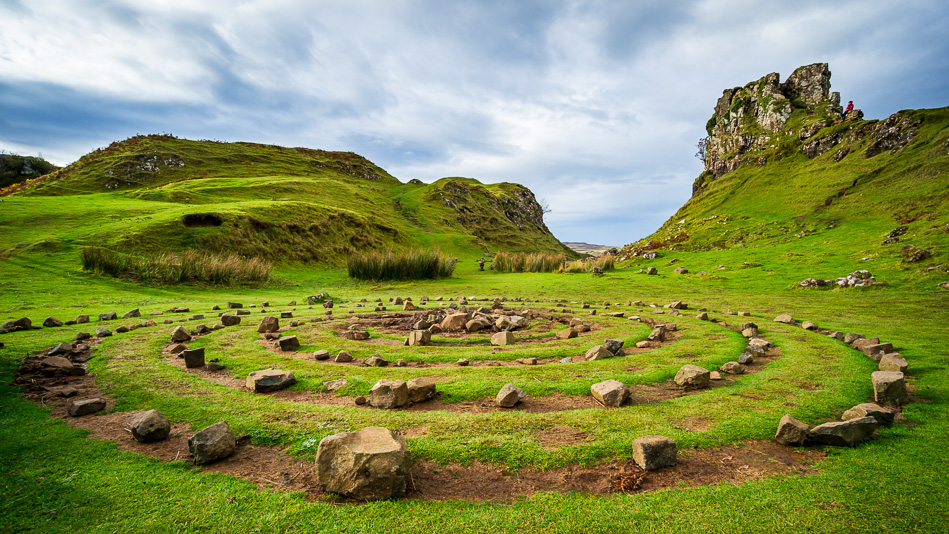
Near the village of Uig, Fairy Glen is a strange, magical-looking area with green hills, spiral patterns, and small towers made of stones. It looks like something from a fairy tale. It’s a short walk from the road and is marked on walking and tourist maps.
Dunvegan Castle
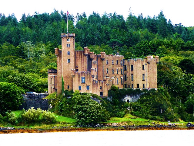
Located on the west side of the island, about 35 minutes from Portree by car. It is the oldest castle in Scotland still lived in by the same family the MacLeods. The castle and its gardens are open to visitors and clearly marked on all regional Skye maps.
Isle Of Raasay
Just across the water from Portree, Raasay is a smaller island you can reach by ferry from Sconser (about 20 minutes from Portree). It has quiet roads, scenic views, walking trails, and a distillery. Maps show the ferry route and walking paths across the island.
Lealt Falls
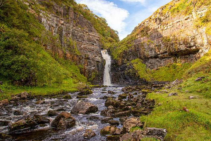
Located between Portree and Staffin, Lealt Falls is a beautiful waterfall dropping into a gorge below. There’s a viewing platform just off the A855 road, and it’s usually marked on road and walking maps as a photo stop.
Brother’s Point (Rubha Nam Brathairean)
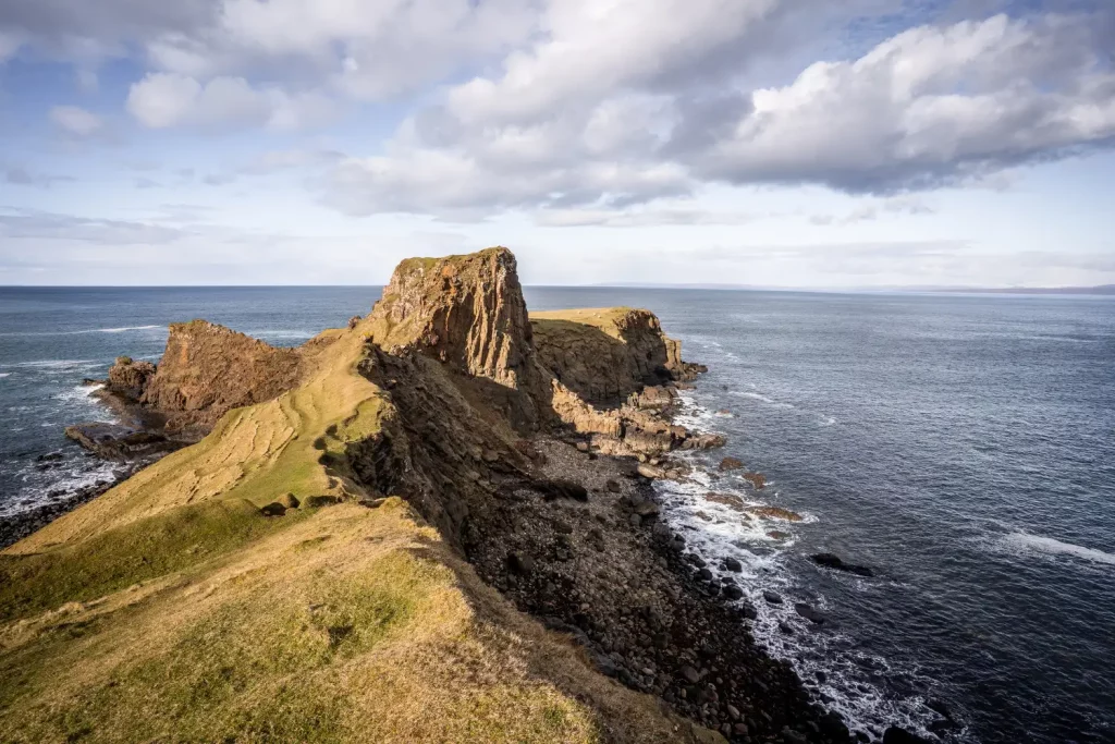
A short walk from the main road north of Portree takes you to this quiet headland. Brother’s Point is less crowded than the Old Man of Storr or Quiraing, but still has amazing sea views and rocky cliffs. It’s often shown on hiking maps as a coastal trail.
An Corran Beach (Dinosaur Footprints)
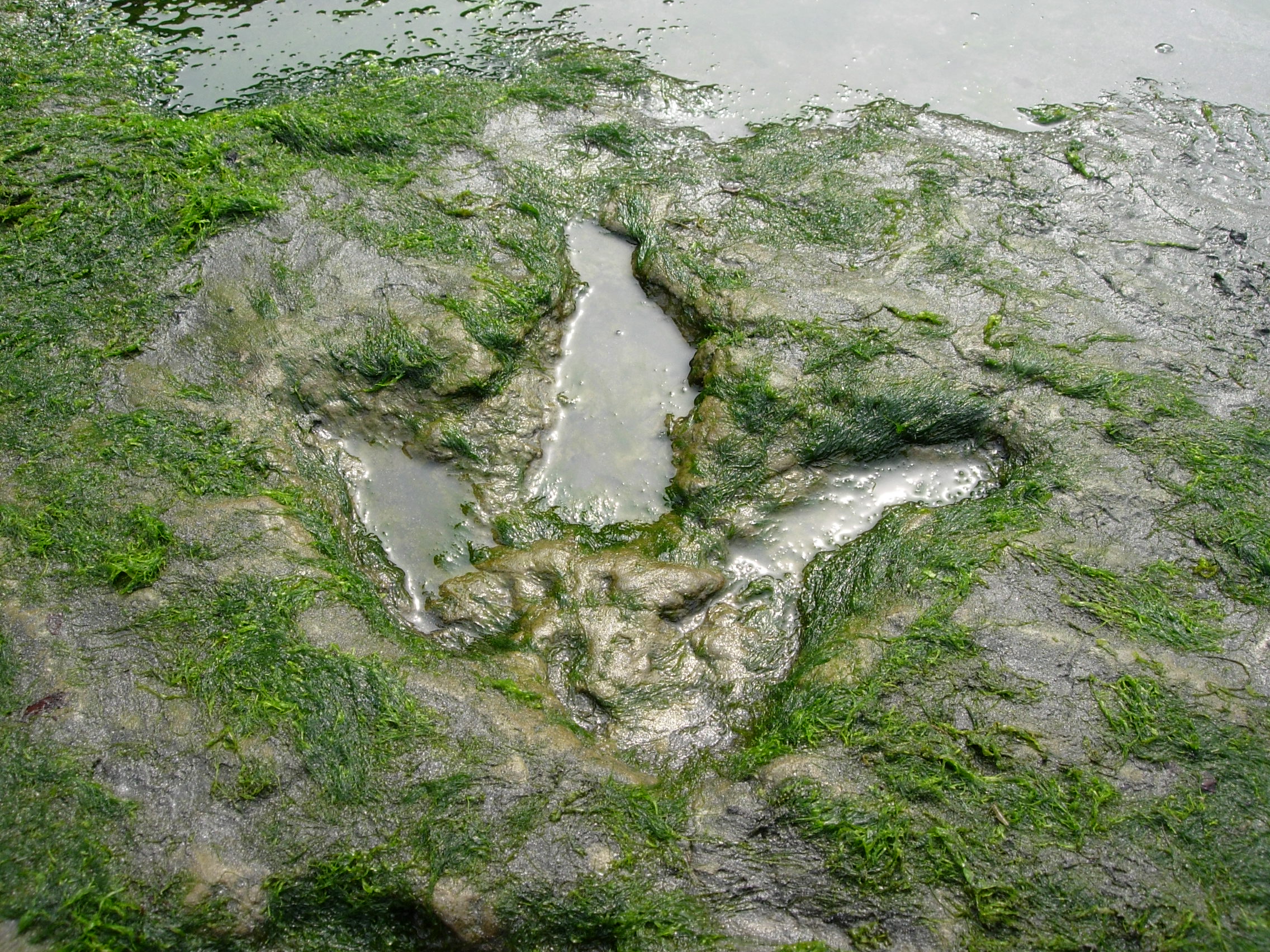
Near Staffin, this beach is famous for real dinosaur footprints in the rocks. At low tide, you can see them clearly. Families and geology lovers enjoy this spot. It’s marked on local information signs and geological interest maps.
Rha Waterfalls
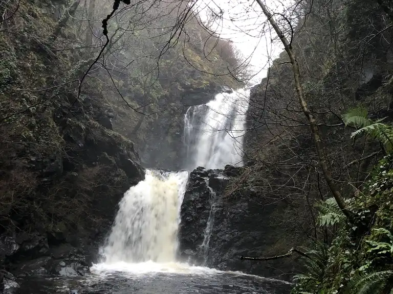
Close to Uig, these twin waterfalls are hidden in a small woodland area. It’s a peaceful place for a short walk and is often marked on smaller village maps and walking leaflets.
Ben Tianavaig
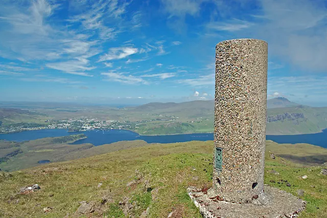
A hill just south of Portree, Ben Tianavaig offers a quiet hike with views over Portree, Raasay, and the Sound. It’s shown on topographic and walking maps and is less busy than Storr or Quiraing.
3-Day Itinerary From Portree
Day 1 - Portree & Local Walks
- Morning: Scorrybreac Trail walk
- Midday: Lunch at Portree Harbour
- Afternoon: Walk up The Lump, visit Somerled Square shops
- Evening: Watch sunset from the harbour or join a seal-spotting boat tour
Day 2 - North Skye (Trotternish Ridge)
- Morning: Drive to Old Man of Storr, hike
- Late Morning: Stop at Lealt Falls
- Lunch: Picnic or café stop in Staffin
- Afternoon: Visit Kilt Rock & Mealt Falls, walk Brother’s Point
- Evening: Optional visit to Fairy Glen before returning to Portree
Day 3 - West Skye Or Raasay
Option A:
- Morning: Drive to Dunvegan Castle, tour castle and gardens
- Afternoon: Stop at Edinbane Inn or walk in Rha Waterfalls
Option B:
- Morning: Ferry to Isle of Raasay from Sconser
- Walk around Inverarish, visit Raasay Distillery
- Return to Portree in the evening
Fun Facts About Portree, Isle Of Skye
Portree may be a small town, but it has a fascinating mix of history, culture, and natural beauty that makes it stand out on the Isle of Skye. These fun facts provide unique insights for travellers and add personality to any travel guide or article.
1. Portree Means "Port Of The King"
The name Portree comes from the Scottish Gaelic “Port Rìgh,” which translates to “Port of the King.” This name dates back to a visit by King James V of Scotland in 1540, who is said to have landed here with a fleet to meet the island’s clan leaders. The royal visit left such an impression that the town adopted a name to honour the event.
2. The Colourful Harbour Is One Of The Most Photographed Spots In Scotland
The harbour in Portree is famous for its row of pastel-painted buildings that line the waterfront. These houses often appear in tourism brochures, guidebooks, and social media posts about Scotland. Visitors regularly stop here for photographs, especially during sunrise and sunset when the reflections in the water are at their best.
3. The Skye Highland Games Take Place In Portree Every Summer
Portree hosts one of the oldest and most traditional Highland Games in Scotland, usually held in early August on The Lump, a grassy hill near the centre of town. These games include piping, hammer throws, caber tossing, tug-of-war, and dancing competitions, drawing both locals and visitors from across the world.
4. Portree Is The Only Official Town On The Isle Of Skye
Although Skye has many villages, such as Staffin, Uig, Broadford, and Dunvegan, Portree is the island’s only official town. As a result, it serves as the administrative, cultural, and commercial centre for the whole island, with facilities such as a hospital, high school, council offices, and main transport links.
5. You Can Begin Scenic Hikes Right From The Town Centre
One of Portree’s most accessible walks is the Scorrybreac Trail, which begins close to the harbour. This circular route takes visitors through peaceful woods, along sea cliffs, and past viewpoints overlooking the Sound of Raasay. It's a favourite among locals and ideal for anyone who wants a short, scenic walk without leaving town.
6. Portree Has Appeared In Films And Documentaries
While most of Skye’s film scenes are shot in its more dramatic landscapes, Portree has featured in travel documentaries, Scottish films, and nature programmes. It’s also a popular base for film crews working on location in nearby places like the Quiraing and Old Man of Storr.
7. The Town Offers Some Of The Best Dining On The Isle Of Skye
Despite its size, Portree is home to several award-winning restaurants, seafood bistros, and traditional Scottish pubs. Many chefs here focus on fresh, locally sourced ingredients such as Skye langoustines, mussels, venison, and cheeses. It’s quietly becoming a destination for food lovers who want quality without the crowds of big cities.
8. Portree Is Close To Some Of Scotland’s Most Iconic Natural Landmarks
Within a 20 to 40-minute drive from Portree, visitors can reach some of the Isle of Skye’s most famous attractions, including the Old Man of Storr, Kilt Rock, The Quiraing, and Lealt Falls. Because of this, the town is often used as a base for exploring the island’s most scenic areas.
9. Portree’s Harbour Has Long Fishing Traditions
Before becoming a tourist destination, Portree was a fishing village. It still retains this heritage, with fishing boats often seen in the harbour and local seafood widely available. The town also played a role in the herring industry in the 19th century, when many boats would dock here to unload their catch.
10. Many Guided Tours Of The Isle Of Skye Start In Portree
Portree is the starting point for most day tours, bus excursions, and outdoor adventures around the island. Whether it’s wildlife boat trips, geological walks, or photography tours, most operators begin here due to the town’s central location, bus access, and visitor facilities.
People Also Ask
What Is Portree Known For?
Portree, the largest town on the Isle of Skye, is a vibrant port and a hub of cultural activity. Nestled around a scenic natural harbour and surrounded by dramatic cliffs and highlands, it attracts many tourists as a popular holiday destination.
How Do I Get To Portree, Isle Of Skye?
Most visitors reach Portree by car or bus via the Skye Bridge, which connects the island to mainland Scotland. The nearest train station is at Kyle of Lochalsh, followed by a bus journey to Skye. Direct buses to Portree also run from Inverness and Glasgow.
What Is The Pride Of Portree?
Pride of Portree were a Quidditch team that played in the British and Irish Quidditch League. Formed in 1292, the team was based in the small town of Portree, which was located on the Isle of Skye, an island of the Inner Hebrides.
What Is The Capital Of The Isle Of Skye?
Portree is the largest and only official town on the island. It serves as the administrative, cultural, and economic centre of Skye. Located on the east coast, Portree is home to essential services like schools, shops, healthcare, public transport, and tourism offices, making it the island’s main hub for both locals and visitors.
Final Thoughts
The Portree Isle of Skye map is more than a guide for getting around; it’s a snapshot of how the island works. Portree’s roads lead to some of Skye’s most famous sights, while its harbour, walking trails, and surrounding villages create a network of experiences rooted in landscape and tradition.
By reading the map with care, travellers can make informed choices, avoid missing key places, and gain a better sense of how the island fits together. In a place shaped by both geography and history, Portree remains a natural starting point and a central thread on any Skye map.
Jump to
Quick Facts About Portree, Isle Of Skye
Geographical Overview Of Portree, Isle Of Skye
History Of Portree, Isle Of Skye
Administrative Centre On The Map Of Portree, Isle Of Skye
Town And Villages On The Map Of Portree, Isle Of Skye
Regions On The Map Of Portree, Isle Of Skye
Population Of Portree, Isle Of Skye
Currency Of Portree, Isle Of Skye
Dialing Code Of Portree, Isle Of Skye
Language Of Portree, Isle Of Skye
Government Of Portree, Isle Of Skye
Total Area Of Portree, Isle Of Skye
Types Of Portree, Isle Of Skye Map
Driving Routes And Transportation In Portree, Isle Of Skye
Walking Routes On The Portree Isle Of Skye Map
Tips For Walking In And Around Portree
National Scenic Areas On The Portree, Isle Of Skye Map
Tourist Attractions On The Portree, Isle Of Skye Map
3-Day Itinerary From Portree
Fun Facts About Portree, Isle Of Skye
People Also Ask
Final Thoughts

Callum Fraser
Author
Callum Fraser isn't just a writer about Scotland; he's a product of its rugged landscape and rich history. Born and raised in Perthshire, with the Highlands as his backyard, his love for the nation's stories was kindled by local storytellers and long walks through ancient glens.
This passion led him to pursue a degree in Scottish History from the University of Edinburgh. For over 15 years, Callum has dedicated himself to exploring and documenting his homeland, fusing his academic knowledge with essential, on-the-ground experience gained from charting road trips through the Cairngorms, hiking the misty Cuillins of Skye, and uncovering the secrets of traditional recipes in his family's kitchen.
As the Editor-in-Chief and Lead Author for Scotland's Enchanting Kingdom, Callum's mission is simple: to be your most trusted guide. He combines meticulous research with a storyteller's heart to help you discover the authentic magic of Scotland — from its best-kept travel secrets to its most cherished traditional recipes.
Latest Articles
Popular Articles