Edinburgh City Centre Map | Your Ultimate 2025 Guide
Don't get lost! Our ultimate Edinburgh city centre map provides local insights, must-see attractions & navigation secrets for a truly enhanced Scottish adventure.
Author:Callum FraserJul 31, 20251.5K Shares110.5K Views

Edinburgh is one of Europe's most captivating capital cities, and its city centre is where history, culture, and architecture collide in dramatic fashion. A detailed map of EdinburghCity Centre is essential for travelers hoping to explore its cobbled streets, Gothic spires, world-class museums, and vibrant neighborhoods without missing a beat.
Whether you're walking the Royal Mile, finding hidden closes in Old Town, or planning your route from the train station to your hotel, having a reliable city centre map saves time and enhances your experience.
Prepare to unlock the secrets of Edinburgh's heart, transforming your visit into an unforgettable journey.
Quick Facts: Edinburgh At A Glance
For those seeking a rapid overview of Scotland's vibrant capital, here's a snapshot of key facts about Edinburgh.
| Population | Approximately 514,990 (metro area, 2025 estimate) |
| Area | 264 km² (102 sq mi) |
| Country | Scotland, United Kingdom |
| Dialing Code | +44 (country code) then 0131 (Edinburgh area code) |
| Currency | Pound sterling (GBP; £) |
| Language | English (Official), Scots, Scottish Gaelic |
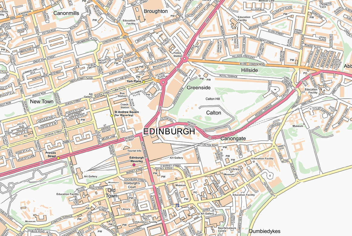
Edinburgh City Centre Map
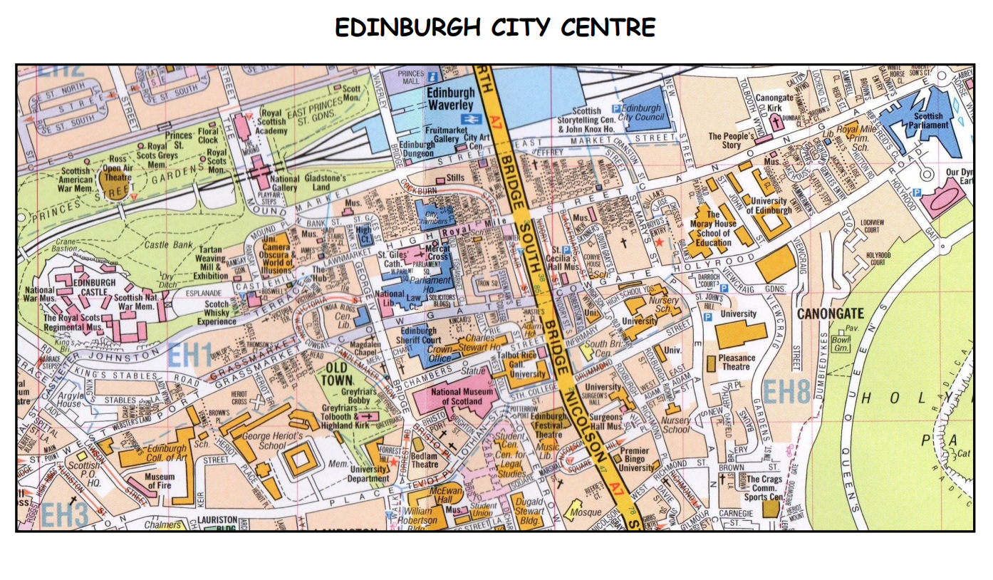
The capital of Scotland may be compact, but it's layered-both literally and historically. The Old Town and New Town are divided by a deep valley and connected by historic bridges. With winding lanes, sudden hills, and countless hidden gems, getting lost is easy-but with the right map, getting found is even better.
A city centre map helps you:
- Plan walking routes between major landmarks
- Locate scenic viewpoints and historical sites
- Access public transport stations with ease
- Save time (and steps) while exploring
Understanding Edinburgh's Core: Old Town Vs. New Town On Your Map
Grasping the fundamental distinction between the Old Town and the New Town is key to navigating Edinburgh with ease. These two primary areas define the Edinburgh city map touristexperience.
Edinburgh Old Town Map
The Old Townis the beating historic heart of Edinburgh and a designated UNESCO World Heritage Site. A quick glance at an Edinburgh Old Town mapreveals a chaotic yet captivating layout-narrow closes, cobbled streets, and towering tenement buildings crowd together in a medieval patchwork. This organic structure reflects centuries of unplanned growth, creating a cityscape that feels like a living museum.
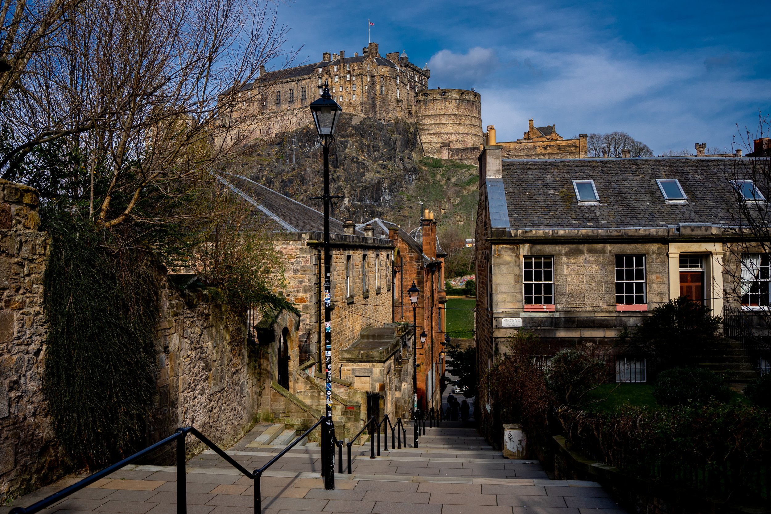
Edinburgh Castle
Perched on an ancient volcanic crag known as Castle Rock, Edinburgh Castledominates both the skyline and the history of the Old Town. It’s the perfect starting point for any map-guided exploration.
Map Of Royal Mile Edinburgh
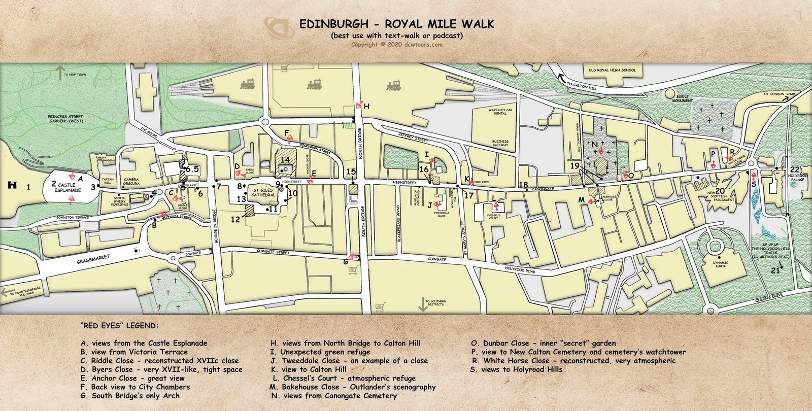
Stretching from Edinburgh Castle to the Palace of Holyroodhouse, the Royal Mileis the city's most iconic thoroughfare. It's not a single road but a chain of historic streets: Castlehill, Lawnmarket, High Street, and Canongate. A detailed map of Royal Mile Edinburgh will highlight architectural treasures, cultural landmarks, and centuries-old gathering places.
Royal Mile Highlights
- St Giles’ Cathedral- The spiritual centerpiece of the High Street.
- The Mercat Cross- A traditional spot for public proclamations.
- Historic Pubs and Shops- From whisky tasting rooms to tartan retailers, the Mile is lined with Scottish charm.
Closes And Wynds
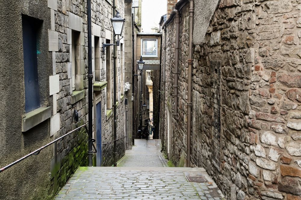
One of the most intriguing features on any Old Town or Royal Mile map are the closesand wynds-narrow alleyways and passageways that lead off the main street. These hidden routes often open into:
- Secret gardens
- Courtyards with ancient tenement buildings
- Historical sites like Mary King’s Close
Each close has a story, and many are named after notable residents or former uses.
Grassmarket
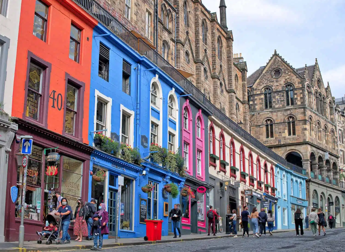
Just below Castlehill sits the Grassmarket, once a bustling venue for livestock trading-and public executions. Today, it's a lively social hub filled with:
- Traditional pubs like The Last Drop
- Boutique shops and vintage stores
- Outdoor seating with sweeping views of the Castle
This square offers a different vantage point of Old Town and is an ideal stop for map-guided walking tours.
Victoria Street & Candlemaker Row
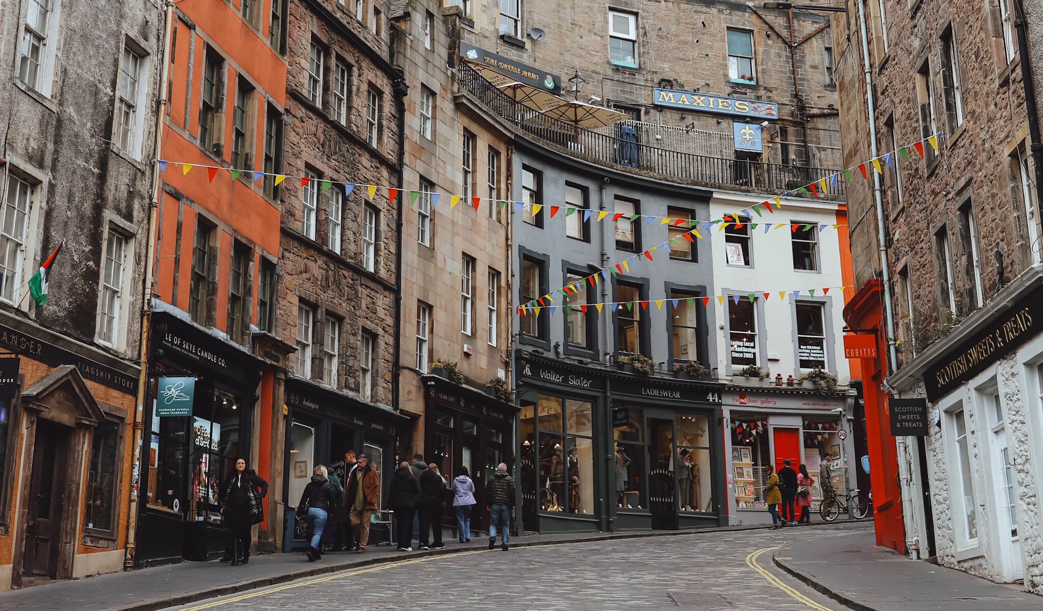
Connecting the Grassmarket to George IV Bridge, these famously curved streets offer some of the most photographed scenes in Edinburgh. Their colorful facades and independent shops feel like something out of a fantasy novel.
Key sites here include:
- The National Museum of Scotland- Just steps away
- Greyfriars Kirkyard- The final resting place of Greyfriars Bobby and inspiration for many literary works
These streets are perfect for travelers who enjoy wandering off the map, even as they stay on course.
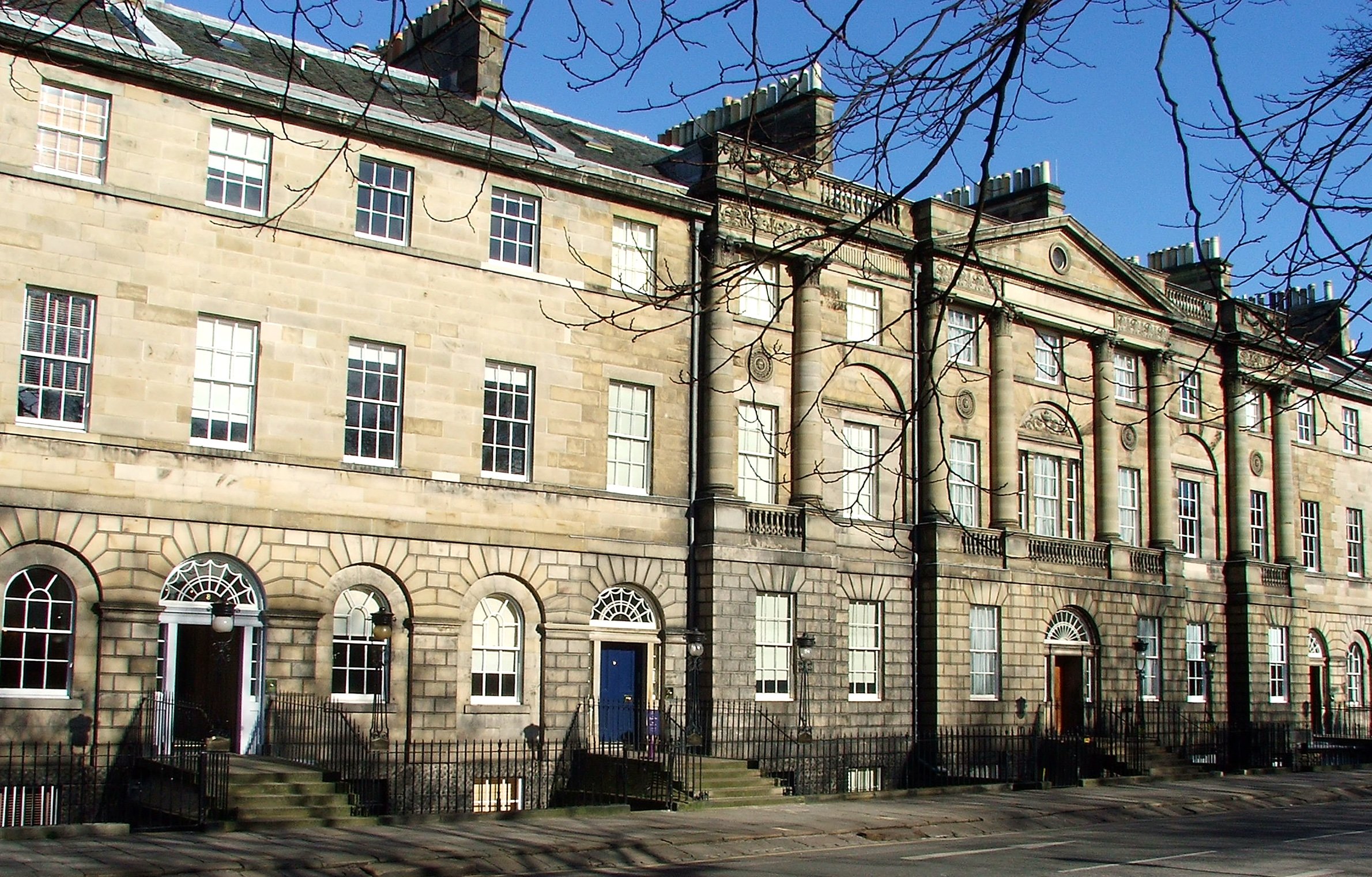
Street Map Edinburgh: Georgian Grandeur Of The New Town
In stark contrast to the organic growth of the Old Town, Edinburgh's New Town was a meticulously planned expansion of the city in the 18th century. It showcases stunning Georgian architecture, broad avenues, and elegant squares. Any street map Edinburghwill clearly show its grid-like structure.
- Princes Street:This is Edinburgh's main shopping street, offering a wide array of high-street brands. What makes it unique are the uninterrupted views of Edinburgh Castle and the Old Town skyline from its south side, thanks to the Princes Street Gardens.
- George Street:Running parallel to Princes Street, George Street is home to upmarket boutiques, hotels, and a vibrant nightlife scene with numerous bars and restaurants. It's characterized by its grand neoclassical buildings.
- Queen Street:Another parallel street in the New Town, Queen Street borders the beautiful Queen Street Gardens (private access for residents, but enjoyable views from the street). It's quieter than Princes Street or George Street, offering a more residential feel.
- St Andrew Square:A prominent Georgian square, St Andrew Square is a transport hub and home to various financial institutions, luxury shops, and popular eateries. The Melville Monument stands proudly in its centre.
Tourist Map Of Edinburgh City Centre
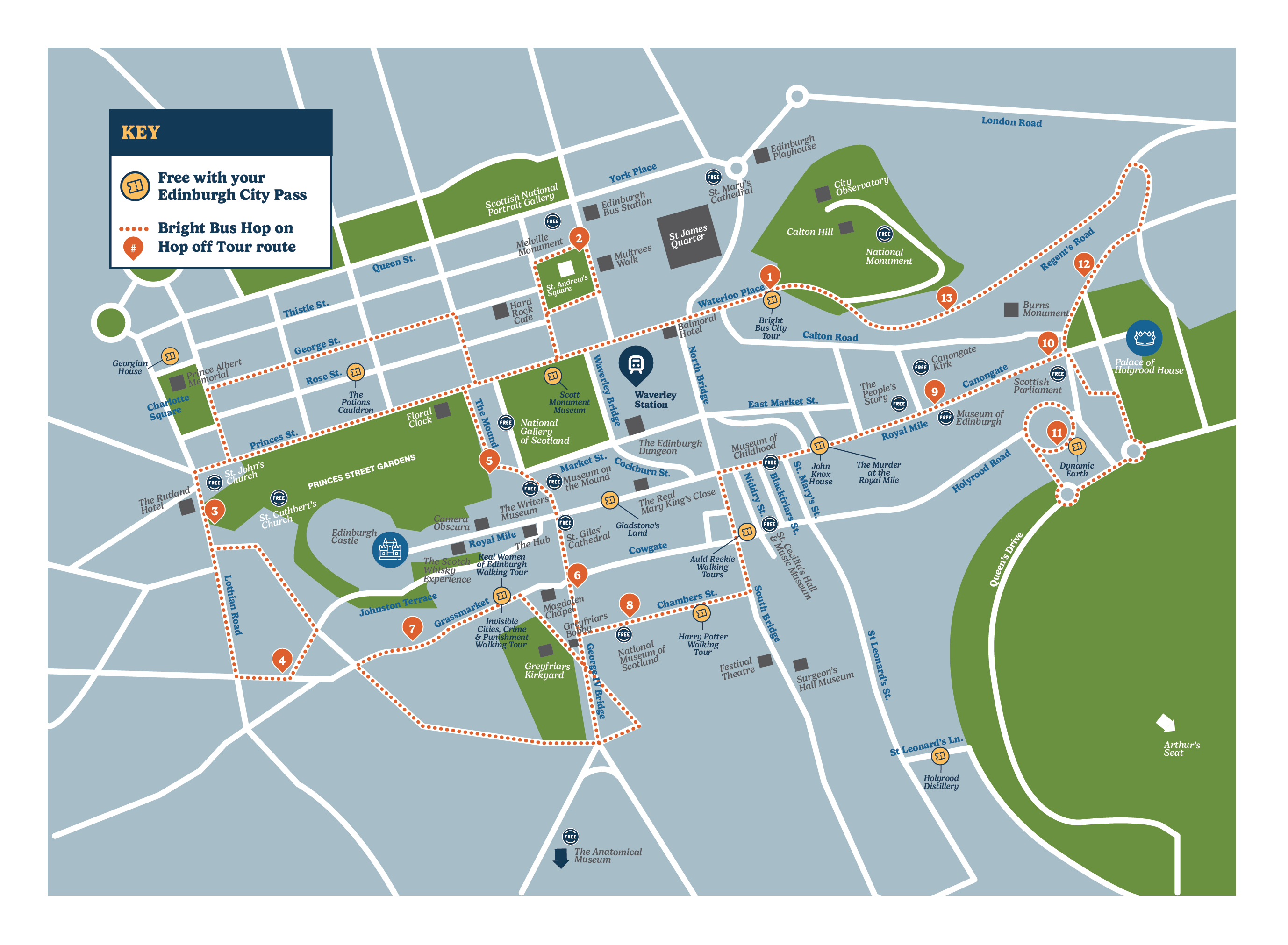
Key Landmarks And Must-See Attractions On The Edinburgh City Centre Map
Understanding the layout becomes even more practical when you pinpoint the major attractions within the city centre. Many are within comfortable walking distance of each other, and all are typically highlighted on a tourist map of Edinburghcity centre.
- Edinburgh Castle:The city's most iconic landmark, offering panoramic views and a deep dive into Scottish history. It sits at the top of the Royal Mile.
- Palace of Holyroodhouse:The King's official residence in Scotland, located at the opposite end of the Royal Mile from the Castle.
- National Museum of Scotland:A treasure trove of Scottish history, natural history, and world cultures, located just off Chambers Street, south of the Royal Mile. They also have a fantastic roof terrace with unparalleled views across the city.
- Scottish National Gallery:Situated in the heart of Princes Street Gardens, this gallery houses Scotland's national collection of fine art from the early Renaissance to the late 19th century.
- Scott Monument:A towering Victorian Gothic monument dedicated to Sir Walter Scott, located in Princes Street Gardens, offering challenging climbs for spectacular views.
- Calton Hill:East of the New Town, Calton Hill offers some of the best panoramic views of Edinburgh, including the Old Town, Arthur's Seat, and the Firth of Forth. It's home to several monuments, including the National Monument.
- Scottish National Portrait Gallery:Housed in one of Edinburgh's most incredible buildings, this gallery explores Scottish history through portraits, including those of Mary Queen of Scots and Robert Burns.
Different Types Of Edinburgh Maps For Different Needs
While a standard Edinburgh city centre mapis essential for first-time visitors, the real magic of navigating the city lies in using specialized maps tailored to your interests. Whether you're chasing a show at the Fringe or following the footsteps of J.K. Rowling, there’s a map for that.
Festival Maps
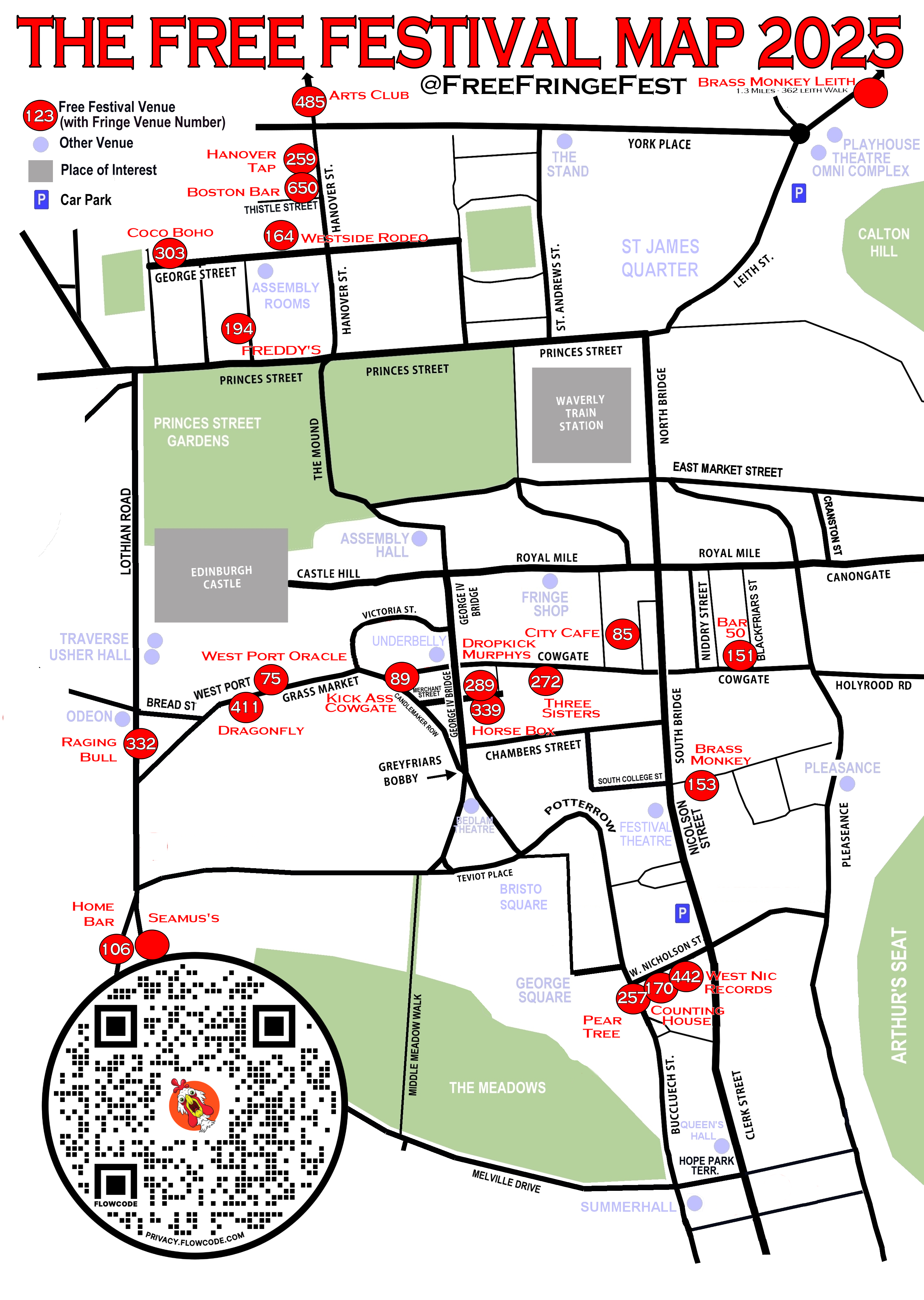
Each summer, Edinburgh transforms into the world’s largest stage during the Edinburgh Festival Fringe. To help you find your way through hundreds of pop-up venues and event locations, official Fringe mapsare distributed across the city and available online.
- Covers: Theatre venues, comedy clubs, street performance areas, and box office locations.
- Pro Tip: Download the EdFringe app, which includes a real-time, GPS-enabled map.
Walking & Cycling Maps
Edinburgh is a walkable city filled with scenic paths, and cyclists will find numerous dedicated lanes and off-road routes.
Includes:
- Water of Leith Walkway
- Union Canal path
- Holyrood Park trails
- Green spaces like The Meadows and Inverleith Park
Available through: Edinburgh Council, Sustrans Scotland, or AllTrails.
Public Transport Maps
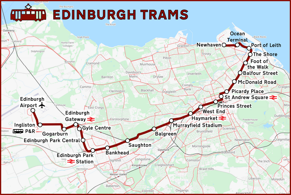
Getting around Edinburgh is easy thanks to its efficient bus and tram network. If you're venturing outside the city centre to areas like Leith, Portobello, or the Airport, a Lothian Buses mapor Edinburgh Tram mapis a must.
Find these at:
- Lothian Buses travelhubs
- Edinburgh Trams stations
- Digital apps like Transport for Edinburgh
Historical Overlay Maps
History lovers can dig deeper using historical overlay maps, which show how Edinburgh’s layout has changed through the centuries. These maps often reveal:
- The pre-Georgian expansion
- Lost buildings or ancient walls
- 17th–19th century street names still echoed in closes and wynds
- Where to find:
Themed Maps For Unique Explorations
Some of the most memorable Edinburgh experiences come from themed self-guided map trails. These niche maps bring a playful or immersive angle to your visit:
- Literary Maps: Trace sites connected to Robert Louis Stevenson, Muriel Spark, and Irvine Welsh.
- Harry Potter Maps: Visit inspirations for Diagon Alley (Victoria Street), Tom Riddle’s grave (Greyfriars Kirkyard), and more.
- Ghost & Haunted Edinburgh Maps: Mark your path through the city’s eerie history, including haunted closes and graveyards.
Navigating Edinburgh City Centre: Practical Map Insights
While walking is often the best way to explore Edinburgh's compact city centre, understanding public transport options and key routes enhances your experience. Your Edinburgh city centre mapwill be invaluable for this.
Walkability:The city centre is highly walkable, though expect hills, particularly in the Old Town. Comfortable shoes are a must. Most major attractions are accessible on foot from a central point like Waverley Station.
Public Transport:
- Buses:Lothian Buses operate an extensive network throughout the city and surrounding areas. Their day tickets offer excellent value. Look for bus stops prominently marked on maps.
- Trams:The Edinburgh Trams connect Edinburgh Airport to the city centre (stopping at Princes Street and St Andrew Square) and further east to Leith. It's an efficient way to travel along its specific route.
Waverley Station:Edinburgh Waverley is the main railway station, centrally located between the Old Town and New Town, making it an ideal arrival point and a landmark on any city centre map.
North Bridge and South Bridge:These two significant bridges connect parts of the Old Town over the valleys that were once lochs (like the Nor Loch, now Princes Street Gardens). They are key arterial routes.
One-Way Systems & Pedestrian Zones:Be aware that certain streets, especially within the Old Town, have one-way systems or are pedestrianized, which is crucial if you are driving or using ride-sharing services.
Discovering Hidden Gems With A Free Map Of Edinburgh City Centre
A truly useful free map of Edinburgh city centreshouldn’t just highlight the Royal Mile or Edinburgh Castle-it should also help you uncover those quiet corners and lesser-known streets that give the city its soul. While many printed tourist maps skip over these, you can mark them manually or use a custom Google My Maps layer to ensure you don’t miss out.
Circus Lane (Stockbridge)
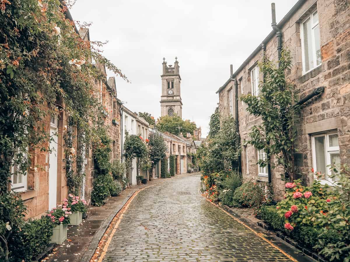
Though just beyond the traditional city centre boundary, Circus Laneis worth every step. This quaint, cobbled mews street in Stockbridgeis lined with ivy-covered stone homes, overflowing flower boxes, and an iconic view of St Stephen’s Churchin the background.
- Map Tip:It's an easy 10–15 minute walk from New Town.
- Why Go:Arguably the most Instagrammable streetin Edinburgh.
Dean Village
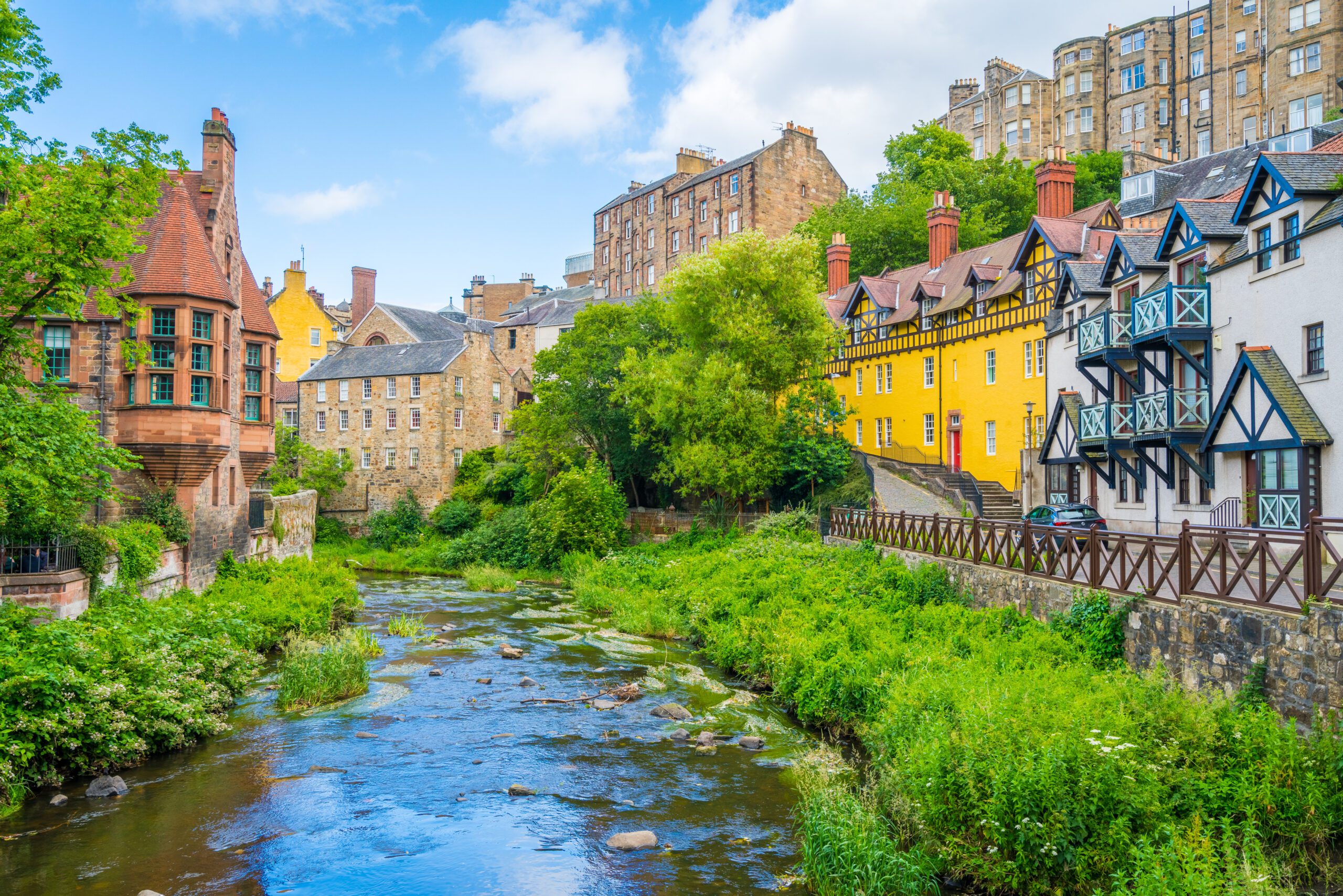
Nestled along the Water of Leith, Dean Villagefeels worlds away from the nearby hustle of Princes Street. This peaceful enclave was once a milling village, and its 19th-century stone houses and riverside trails create an idyllic escape.
- Map Tip:Add it to your route from the West End of New Town.
- Why Go:Perfect for photography, riverside walks, and serene vibes.
Dunbar's Close Garden

Hidden in plain sight just off the Canongateportion of the Royal Mile, Dunbar’s Close Gardenis a meticulously restored 17th-century garden. Box hedges, gravel paths, and benches make it a welcome retreat for travelers needing a quiet break.
- Map Tip:Look for a discreet entrance near Canongate Kirk.
- Why Go:Offers a rare moment of peace steps from the Royal Mile crowds.
The Vennel
Just off the Grassmarket, the Vennelis a steep, narrow stairway that delivers one of the best framed views of Edinburgh Castle-especially stunning at sunset or after dark when the Castle is lit up.
- Map Tip:Access it between the Grassmarket and Lauriston Place.
- Why Go:A must for photographers seeking a classic shot of the Castle.
The Georgian House (Charlotte Square)
Located in Edinburgh’s New Town, the Georgian Houseis a preserved late 18th-century townhouse that offers insight into upper-class Edinburgh life during the Enlightenment.
- Map Tip:Found at No. 7 Charlotte Square, just off George Street.
- Why Go:Step back in time and see how Edinburgh’s elite once lived.
Pro Tip:
Customize your free map of Edinburgh city centreby adding these hidden gems via Google My Maps, Sygic Travel, or Maps.me, which allow for offline access and personal notes.
Edinburgh's Local Favourites
A local's insights can transform your trip. While a tourist map of Edinburgh city centre covers the main attractions, here are some beloved spots that add extra flavour to your visit.
Shopping:
- Golden Hare Books: A highly-regarded independent bookshop, a haven for bookworms.
- Life Story: A chic Scandi lifestyle shop perfect for homewares, jewellery, and gifts.
- Curiouser & Curiouser: More than just a framing shop, it offers a beautifully curated selection of unique gifts, books, and cards with two locations (Broughton and Bruntsfield).
Cafés:
- Wellington Coffee: Known for its delicious hot chocolate with handmade marshmallows. A tiny, cozy spot perfect for people-watching.
- Eteaket: A tea lover's paradise offering delicious afternoon tea, scones, and an incredible selection of artisan teas.
- Artisan Roast: An Edinburgh institution, known for its gourmet coffee and delicious cakes, with locations in Stockbridge, Broughton, and Bruntsfield.
Food & Drink:
- The Outsider:Offers some of the best views of Edinburgh Castle, especially from its window seats, alongside delicious food and a relaxed vibe.
- Mary's Milk Bar:Famous for its amazing handmade gelato in an adorable retro setting right in the heart of Edinburgh's Old Town.
- Locanda di Gusti:A wonderful, authentic Italian restaurant known for its warm atmosphere. Booking is highly recommended due to its small size.
Practical Tips For Using An Edinburgh City Centre Map
Whether you're using a digital or a free map of Edinburgh city centre, these tips will help you navigate like a pro.
- Digital vs. Physical:While digital maps (Google Maps, Apple Maps) are invaluable for real-time navigation and public transport information, a physical map can be useful for getting an overall sense of direction, marking places, and when battery life is a concern.
- Orientation:Always try to orient yourself with Edinburgh Castle. Its prominent position helps in understanding your location relative to the Old and New Towns.
- Elevation:Remember Edinburgh is built on hills. What looks like a short distance on a flat map might involve a steep climb. Factor this into your walking times.
- Pre-plan Your Routes:Before heading out, take a moment to look at your map and plan your general route, especially if you have specific attractions in mind.
- Local Information Centres:Visit the official Edinburgh Tourist Information Centre (located on Market Street, near Waverley Station) for free map of Edinburgh city centreoptions and expert advice.
FAQs About The Edinburgh City Centre Map
What Is Considered The City Centre Of Edinburgh?
The city centre of Edinburgh generally encompasses the Old Town and the New Town. The Old Town stretches from Edinburgh Castle down the Royal Mile to the Palace of Holyroodhouse, while the New Town covers the area primarily north of Princes Street, characterized by its Georgian architecture.
What Is The Main Street In Edinburgh City Centre?
Princes Street is widely considered the main shopping street in Edinburgh city centre, known for its extensive retail options and stunning views of Edinburgh Castle. Historically, the Royal Mile holds significance as the main thoroughfare of the Old Town.
What Is The Royal Mile In The Edinburgh Map?
The Royal Mile is the historic spine of Edinburgh's Old Town, running approximately one Scots mile between Edinburgh Castle at the top and the Palace of Holyroodhouse at the bottom. It's depicted as a central, winding street on any Edinburgh Old Town mapor Map of Royal Mile Edinburgh.
Where To Go In Edinburgh City Centre For First-time Visitors?
For first-time visitors, starting with Edinburgh Castle and then walking down the Royal Mile is highly recommended to immerse yourself in the city's history. Afterward, explore Princes Street and the New Town for shopping and grand architecture. Don't forget to visit the National Museum of Scotland and consider a climb up Calton Hill for panoramic views.
How Do I Get A Free Map Of Edinburgh City Centre?
You can often obtain a free map of Edinburgh city centrefrom the Edinburgh Tourist Information Centre on Market Street, hotels, or some larger attractions. Many public transport hubs also offer basic city maps. Online resources and mobile apps also provide excellent free digital maps.
A Quick Recap
Navigating the Edinburgh city centre mapis more than just finding your way; it's about appreciating the unique historical layers that make this city so special. From the dramatic contours of the Old Town, dominated by its majestic castle, to the elegant symmetry of the New Town, every street tells a story.
Armed with a clearer understanding of its layout, key landmarks, and practical transport tips, you're now poised to explore Edinburgh's heart with confidence and curiosity.
Embrace the winding closes, marvel at the Georgian facades, and discover your own favourite corners. The true magic of Edinburgh lies in the seamless blend of its past and present, all beautifully laid out for you to uncover. If you found this guide helpful, consider sharing it with fellow travellers planning their Scottish adventure!
Continue Reading: 32 Top Things To Do In Edinburgh, Scotland [Expert Picks]
Jump to
Quick Facts: Edinburgh At A Glance
Edinburgh City Centre Map
Understanding Edinburgh's Core: Old Town Vs. New Town On Your Map
Tourist Map Of Edinburgh City Centre
Different Types Of Edinburgh Maps For Different Needs
Navigating Edinburgh City Centre: Practical Map Insights
Discovering Hidden Gems With A Free Map Of Edinburgh City Centre
Edinburgh's Local Favourites
Practical Tips For Using An Edinburgh City Centre Map
FAQs About The Edinburgh City Centre Map
A Quick Recap

Callum Fraser
Author
Callum Fraser isn't just a writer about Scotland; he's a product of its rugged landscape and rich history. Born and raised in Perthshire, with the Highlands as his backyard, his love for the nation's stories was kindled by local storytellers and long walks through ancient glens.
This passion led him to pursue a degree in Scottish History from the University of Edinburgh. For over 15 years, Callum has dedicated himself to exploring and documenting his homeland, fusing his academic knowledge with essential, on-the-ground experience gained from charting road trips through the Cairngorms, hiking the misty Cuillins of Skye, and uncovering the secrets of traditional recipes in his family's kitchen.
As the Editor-in-Chief and Lead Author for Scotland's Enchanting Kingdom, Callum's mission is simple: to be your most trusted guide. He combines meticulous research with a storyteller's heart to help you discover the authentic magic of Scotland — from its best-kept travel secrets to its most cherished traditional recipes.
Latest Articles
Popular Articles