Oban Town Centre Map Guide | Streets, Shops & Landmarks
Find your way around Oban with this comprehensive town centre map guide. Learn where to shop, walk, and sightsee like a local.
Author:Callum FraserJul 16, 202525.3K Shares415.7K Views
Oban is a small harbour town on the west coast of Scotland. It’s a busy place where ferries, trains, and cruise ships bring visitors in every day. The town centre is full of shops, cafés, and beautiful views but with so much going on, it’s easy to miss something.
A good town map helps you see where to go, how to get there, and what’s nearby. It makes your time in Oban easier and more enjoyable no matter how long you're staying or how you're getting around.
Quick Facts About Oban Town Centre Map
- Location: Oban, Argyll and Bute, West Coast of Scotland
- Map Focus: Town centre, ferry terminal, transport links, landmarks, shops, and walking routes
- Popular Landmarks on Map: McCaig’s Tower, Oban Distillery, Oban Ferry Terminal, St Columba’s Cathedral
- Main Streets: George Street, Argyll Square, Stevenson Street
- Transport Hubs: Oban Train Station, Bus Station, Ferry Terminal
- Walking-Friendly: Yes, most places are within 5-10 minutes on foot
- Map Types Available: Paper maps, digital downloads, mobile-friendly versions
- Where to Get It: Tourist information centre, ferry terminal, hotels, cafés, VisitScotland website
- Best Use: Planning routes, finding local spots, understanding the layout of the town
- Extra Features on Some Maps: Parking zones, public toilets, EV points, seasonal event areas
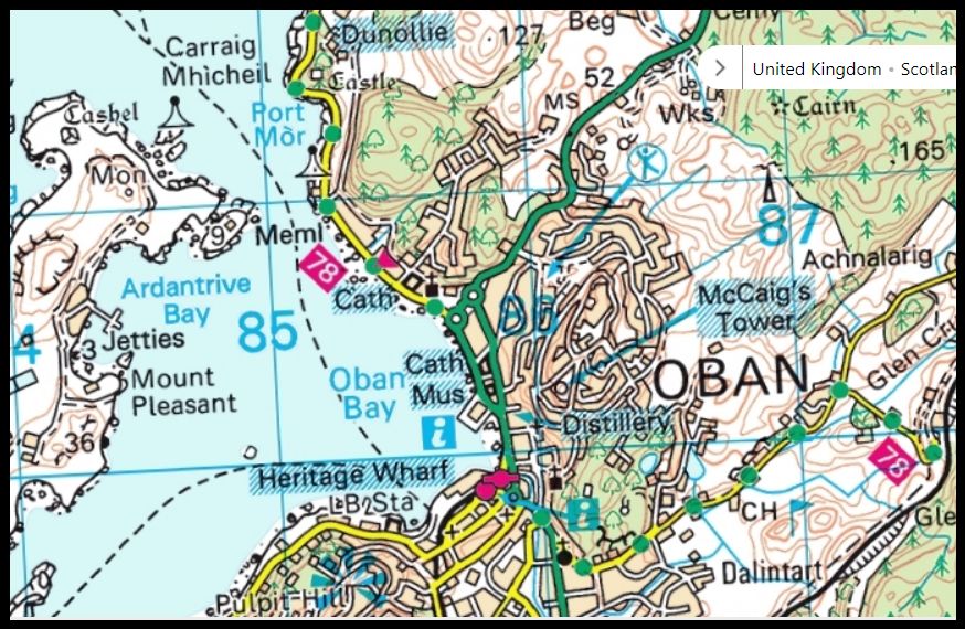
Geographical Overview Of Oban Town Centre
Oban town centre is located on the west coast of Scotland in a sheltered bay facing the island of Kerrera. It sits in the council area of Argyll and Bute and is often called the "Gateway to the Isles" because it connects mainland Scotland to the Inner Hebrides by ferry. The town is built along the curve of Oban Bay, with most streets running near the waterfront. Behind the town centre, the land rises into low hills, including the hill where McCaig’s Tower stands.
The main roads connect the harbour area with nearby neighbourhoods and countryside routes. Because the town is small and compact, most places in the town centre are easy to reach on foot within 10-15 minutes. Oban’s location by the sea, with its busy harbour and railway station, makes it a key travelpoint for visitors heading to islands like Mull, Iona, and Lismore.
This makes Oban a perfect starting point for anyone looking for an authentic Scotland travel experience. The geographical layout shown on town maps highlights how the water, hills, and roads all fit together in one walkable space.
Landmarks On The Map Of Oban Town Centre
McCaig’s Tower
McCaig’s Tower is one of the most famous places in Oban. It looks like a small Roman coliseum and sits on a hill above the town. You can see it from almost anywhere in Oban. It was built in the late 1800s by a man named John Stuart McCaig, who wanted to give work to local builders. The tower was never finished, but it became a local symbol.
Most town maps show it clearly because it’s such a big part of the Oban skyline. From the tower, visitors can enjoy a wide view of Oban Bay, the harbour, and the nearby islands. It’s a peaceful place and perfect for photos or a short walk.
Oban Distillery
Oban Distillery is located right in the town centre, close to the harbour and George Street. It’s one of the oldest whisky distilleries in Scotland, founded in 1794. The building is small but packed with history, and it’s still making whisky today.
On the map, it is usually marked with a whisky glass symbol or building icon. Many visitors come here for tours to learn how whisky is made and to taste it. Because it’s so close to the town’s main shops and cafés, it’s easy to visit during a walk around the centre.
Oban Ferry Terminal
The Oban Ferry Terminal is one of the busiest places in town. It’s where ferries leave to go to the islands of Mull, Lismore, Coll, Tiree, and more. The terminal includes a ticket office, waiting areas, a car check-in lane, and places to buy snacks.
On a town map, the terminal is shown with ferry or boat icons, and the nearby car parks and bus stops are also usually marked. If you’re taking a ferry or meeting someone arriving by boat, the map makes it easier to find your way around the area.
St Columba’s Cathedral
St Columba’s Cathedral is a large stone church close to the waterfront in Oban. It’s the main Catholic cathedral in the area and has beautiful windows, high ceilings, and quiet spaces for prayer.
The cathedral is easy to find on most maps of the town centre and is usually marked with a cross or church symbol. It's a good place to visit if you're interested in history or architecture, and it also offers peaceful views of the sea from nearby.
North Pier & South Pier
Oban has two main piers, North Pier and South Pier. These are used for different things like boat tours, fishing boats, seafood stalls, and walking paths. The piers are also where people gather to take photos of the bay or enjoy fresh food near the water.
On most town maps, both piers are marked and often labelled by name. They are close to each other, right in the centre of town. North Pier is especially popular, as it’s near many restaurants and cafés, while South Pier is a bit quieter.
Oban War Memorial
The Oban War Memorial is a small monument dedicated to local people who died during the First and Second World Wars. It’s a quiet place to stop and remember, located close to the harbour.
It may not stand out at first, but many detailed maps include it as a marked site of interest. The memorial is surrounded by benches and trees, making it a peaceful spot for reflection and rest during your walk around the town.
Oban Harbour
The harbour is at the heart of the town and a busy place where boats come and go. It’s a great spot to watch fishing boats, ferries, and wildlife. The area around the harbour has cafes, shops, and places to relax by the water.
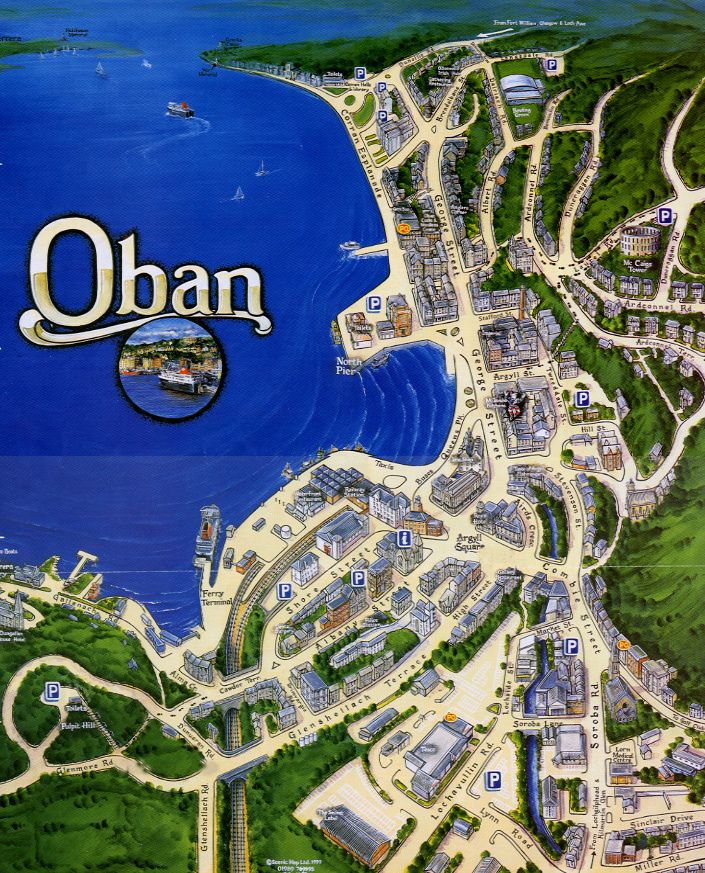
Main Streets And Shopping Areas
Most of Oban’s shops, cafés, and restaurants are located in or around the town centre. A clear map helps you understand where each street goes, so you don’t walk in circles or miss anything important.
George Street
George Street is Oban’s main shopping road. It runs along the waterfront and is full of places to eat, shop, and relax. You’ll find banks, gift shops, clothing stores, and two supermarkets along this street. It’s usually busy with both locals and visitors.
Argyll Square
Argyll Square is a key point in the town centre where several roads meet. It’s often shown as a round or open space on the map. This is where many walking tours begin, and where buses often stop. You’ll also find cafés, hotels, and a post office nearby.
Stevenson Street
Stevenson Street connects the train station area to Argyll Square. It’s a short but useful road with takeaway shops, small local businesses, and side streets leading to more shops or guesthouses. The map helps you follow this street when moving between transport and shopping areas.
Seasonal Markets
During summer and special events like the Oban Winter Festival, the map may show temporary market stalls near the harbour or square. These stalls often sell handmade crafts, local food, and souvenirs. They are usually marked on seasonal versions of the town map or highlighted by visitor centres.
Nearby Cities On The Map Of Oban Town Centre
Oban is not a big city, but it is close to many towns and larger places that are often shown on wider maps of the area. While the town centre map mainly shows streets and landmarks in Oban itself, some regional maps will also include nearby towns and cities for travellers planning longer trips.
Here are some of the nearby cities and towns that may be shown around Oban on travel or transport maps:
- Glasgow- The nearest major city to Oban. It is about 90 miles (145 km) southeast and takes around 2.5 hours by train or car.
- Fort William- A popular town for outdoor adventures. Located north of Oban, it’s about 45 miles (72 km) away and often included in maps showing scenic routes.
- Inveraray- A small town to the east, known for its historic castle. It’s about 37 miles (60 km) from Oban and sometimes marked on regional visitor maps.
- Lochgilphead- A smaller town south of Oban, often shown on maps that include the A816 road, which links the two towns.
- Taynuilt- A nearby village, only 12 miles (20 km) away. While not a city, it’s often included on local maps showing the area around Oban.
- Dalmally- A small village along the road to Crianlarich. It can appear on driving maps connected to Oban.
Also See - Best Hotels In Fort William, Scotland
Types Of Oban Town Centre Map
There are different kinds of maps available for Oban town centre, each designed to help visitors in specific ways. Here are the main types you might come across:
1. Street Map
This map shows all the streets and roads in Oban town centre. It helps people find their way around the town, showing important roads, walking paths, and locations of shops and services.
2. Tourist Map
Tourist maps focus on showing popular attractions, landmarks, and places of interest. These maps often highlight key spots like McCaig’s Tower, the harbour, museums, and parks. They usually include symbols and icons to make it easy for visitors to spot attractions.
3. Walking Trail Map
This type of map highlights footpaths and walking routes around Oban. It is useful for people who want to explore the town on foot, showing trails to viewpoints like Pulpit Hill or along the Esplanade Walk by the coast.
4. Green Spaces And Parks Map
Some maps focus on green areas in and around Oban town centre. These show parks, playgrounds, and quiet spots where visitors can relax. They help visitors find nature spots away from busy streets.
5. Coastal And Harbour Map
This map type focuses on the coastline and harbour area. It shows piers, ferry terminals, and coastal paths. It’s helpful for visitors interested in boat trips or enjoying the sea views.
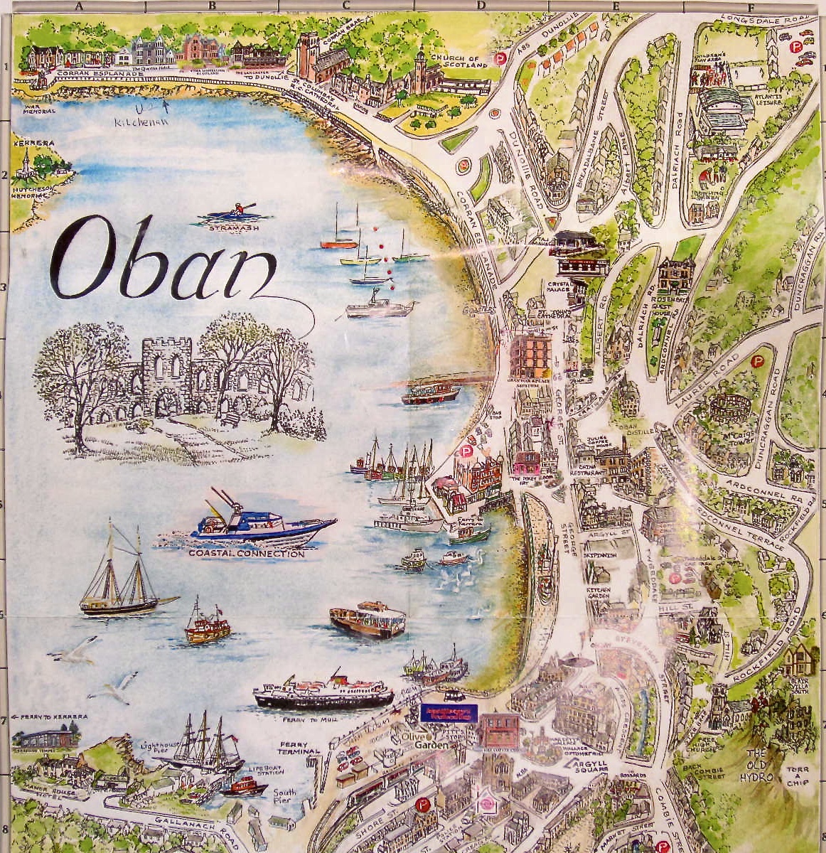
Major Roads And Routes In Oban Town Centre
Oban town centre is connected by several important roads and routes that make getting around easy for visitors and locals alike. These roads link key parts of the town and lead to popular attractions, shops, and transport hubs.
- George Street: George Street is one of the main roads running through the town centre. It is lined with shops, restaurants, and cafes, making it a busy and popular street for visitors. Many maps show George Street as a central route to help people navigate Oban’s core.
- Corran Esplanade: Running along the coastline, Corran Esplanade offers both a road and a scenic route for walking or driving. It connects the harbour area to the southern parts of the town and is a great way to enjoy sea views while moving around.
- George Street to McCaig’s Tower Path: A well-known walking route leads from George Street up to McCaig’s Tower. This path is often marked on town maps and is popular because it takes visitors to one of Oban’s best viewpoints.
- A85 Road: The A85 is a major road that passes through Oban, linking the town with other parts of Scotland. It is the main access road for visitors arriving by car or bus, and it connects to important routes towards Fort William and Perth.
- Harbour Road: Harbour Road runs near the waterfront and leads directly to the ferry terminals. It is a key route for visitors catching boats to nearby islands and coastal destinations.
Oban Transport Locations On The Map
Train Station
Oban’s train station is close to the harbour and clearly marked on most maps. It’s the final stop on the line from Glasgow and one of the main ways visitors arrive in town. The map usually shows it with a train symbol and nearby walking paths.
Bus Station
Right next to the train station is the bus station. It connects Oban to nearby villages and cities like Fort William, Glasgow, and Inverness. Look for a bus icon on the map to find the station and nearby stops.
Ferry Routes
Ferries are an important part of life in Oban. Most maps include dotted lines across the water showing ferry routes to islands like Mull, Kerrera, and Lismore. The ferry terminal is next to the station and is easy to spot on the map.
Taxi Ranks
If you prefer a taxi, maps will show pick-up spots around George Street and near the station. These are often marked with a simple “T” or car symbol so you can find one quickly.
Car Parks
Driving into Oban? Look for the “P” signs on the map to find parking spots. Major car parks include Lochavullin, Shore Street, and Tweeddale Street. Some are short-stay, while others offer all-day parking.
Electric Charging Points
As more people use electric cars, Oban has added charging points. Newer town maps now show these spots clearly, helping drivers plan their stops.
Maps of Oban are also helpful for showing small paths, shortcuts, and pedestrian-only zones. This makes it easier to move around, especially during busy times or when you’re on foot.
Oban Town Centre Dining
Seafood Shacks Near The Ferry Terminal
Next to the ferry terminal, you’ll find small seafood huts selling fresh oysters, mussels, and lobster rolls. These are especially busy in the summer and are clearly marked on most town maps because they are a big attraction for visitors.
Oban Fish & Chip Shop
This is one of the oldest and most loved fish and chip shops in town. It’s usually shown on visitor maps because it’s a favourite stop for both tourists and locals. It’s close to the harbour, making it easy to grab a quick meal by the sea.
Harbour Cafés And Ice Cream Parlours
Along the waterfront, several cafés and ice cream shops are marked on tourist maps. These are popular places to sit, relax, and enjoy views of the bay. You’ll often find them marked with a cup or ice cream cone symbol.
Local Pubs And Whisky Bars
Oban has many pubs and small whisky bars, some of which also serve meals. On the map, these are usually shown with a pint glass or a fork and knife icon. They’re great places to try local drinks and enjoy live music in the evenings.
The Oban Chocolate Company
Located near the seafront, this café and shop is known for its handmade chocolates and hot drinks. It's often shown on maps because it's a sweet stop for families, couples, and anyone with a sweet tooth. Some maps use a coffee cup or treat icon to show it.
Ee-Usk Restaurant
This well-known seafood restaurant sits right on the North Pier. It offers views over the bay and serves fresh fish daily. Maps often highlight Ee-Usk because it's a top-rated dining spot in Oban and easy to find from the harbour area.
Perle Oban Hotel Restaurant
This stylish hotel near the station has a restaurant and cocktail bar that's open to non-guests. It’s usually shown on town centre maps because of its central location and popularity with visitors.
Piazza
Next to Ee-Usk, Piazza is a family-friendly Italian-style restaurant offering pasta, pizza, and bay views. It’s often featured on printed and digital maps for tourists looking for something other than seafood.
The Lorne Bar
A relaxed pub known for hearty meals and live sports. It’s marked on maps close to the train station and is easy to reach from the ferry terminal too.
Coast Restaurant
Found just off George Street, this is a cosy but classy place to enjoy seafood and fine dining. Maps sometimes highlight it with a fork-and-knife icon or by name.
Cultural And Historical Places On The Oban Town Centre Map
Oban is a small town, but it has a deep and interesting history. Town maps often mark special cultural and historical places so visitors can find more than just food, shops, and ferries.
Dunollie Museum, Castle & Grounds
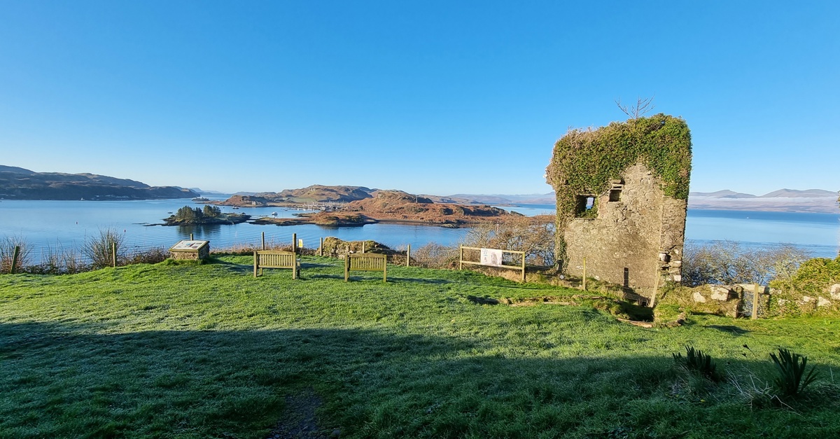
Located just north of the town centre, Dunollie is a mix of castle ruins, museum displays, and peaceful gardens. It tells the story of the Clan MacDougall and Oban’s early days. Many maps show it near the coast road, just a short walk or drive from the centre.
Oban War And Peace Museum
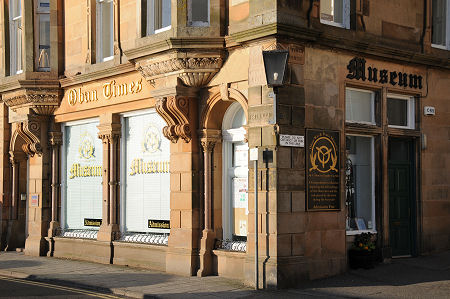
This museum is right near the waterfront. It’s free to visit and shares stories about Oban during both World Wars. The building is small but full of photos, uniforms, and local history. You’ll often find it marked on tourist maps with a museum icon.
Local Art Galleries
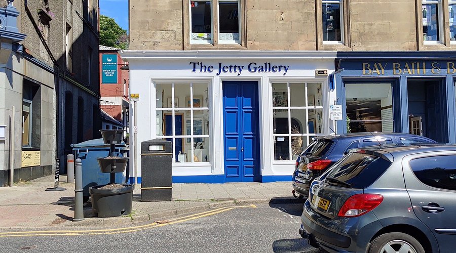
Oban has a few small art galleries, often near George Street or in hidden courtyards. These places change sometimes, but larger or long-standing galleries are usually marked on printed maps or visitor guides.
Oban Library & Phoenix Cinema

The public library and the Phoenix Cinema are both included on many maps, especially ones for families or cultural visitors. They offer good indoor options for rainy days, and both are located within walking distance of Argyll Square.
Peaceful Green Spaces And Coastal Walks Around Oban Town
Pulpit Hill Viewpoint
Pulpit Hill Viewpointis just south of the town centre. It is a popular spot for visitors who like to walk and enjoy nature. Many maps show this place because it is part of local walking trails. From here, you can get a great view of Oban and the surrounding sea. The walk up to Pulpit Hill is peaceful and not too hard, making it a nice place to take a break and relax.
Esplanade Walk
The Esplanade Walk is a lovely path that runs along the coast of Oban. On most town maps, this walk is marked with a special line showing it is a footpath. Walking here, you can enjoy fresh sea air and beautiful views of the water. It’s a perfect place for a slow stroll, and many people come here to watch the boats and enjoy the calm sea.
Children’s Play Parks
There are several play parks around Oban, and some are close to the harbour. These parks are easy to find on maps because they often have a symbol of a tree or a swing. These areas are great for families with children, offering safe spaces for kids to play and have fun. They are peaceful spots where you can rest while the children enjoy themselves nearby.
Quiet Green Spaces
Even if you only have a short time in Oban, the town map shows many quiet green spaces. These spots are away from busy streets and are perfect for a quick rest or some peaceful moments. The green areas are easy to reach by walking and give visitors a chance to enjoy nature right in the town.
People Also Ask
What Are The Main Attractions Shown On The Oban Town Centre Map?
Key attractions include McCaig’s Tower, Oban Harbour, the Distillery, and St. Columba’s Cathedral.
Does The Oban Town Centre Map Highlight Walking Routes?
Yes, the map features several walking and cycling trails within and around Oban. Notably, the Oban Walking and Cycling Map offers self-guided trails, interactive tours, and an Eye Spy game, allowing visitors to explore the town's landmarks and scenic views.
Where Can I Find A Printable Version Of The Oban Town Centre Map?
Printable versions of the Oban town centre mapare available through various sources, including the Oban Walking and Cycling Map provided by Argyll and Bute Council.
Are Children’s Play Areas And Parks Included On The Map?
Most maps mark green spaces and play parks, often using symbols like trees or swings.
Final Thoughts
A town map does more than just help you find your way, it helps you enjoy your visit without stress. In Oban, the map brings together everything that makes the town special, from the ferry terminal to McCaig’s Tower.
Planning ahead with a map saves time, helps you stay on track, and makes it easier to enjoy every part of this charming coastal town.
You Might Also Like - Scotland Map - Explore Cities, Highlands, And Islands In Detail
Jump to
Quick Facts About Oban Town Centre Map
Geographical Overview Of Oban Town Centre
Landmarks On The Map Of Oban Town Centre
Main Streets And Shopping Areas
Nearby Cities On The Map Of Oban Town Centre
Types Of Oban Town Centre Map
Major Roads And Routes In Oban Town Centre
Oban Transport Locations On The Map
Oban Town Centre Dining
Cultural And Historical Places On The Oban Town Centre Map
Peaceful Green Spaces And Coastal Walks Around Oban Town
People Also Ask
Final Thoughts

Callum Fraser
Author
Callum Fraser isn't just a writer about Scotland; he's a product of its rugged landscape and rich history. Born and raised in Perthshire, with the Highlands as his backyard, his love for the nation's stories was kindled by local storytellers and long walks through ancient glens.
This passion led him to pursue a degree in Scottish History from the University of Edinburgh. For over 15 years, Callum has dedicated himself to exploring and documenting his homeland, fusing his academic knowledge with essential, on-the-ground experience gained from charting road trips through the Cairngorms, hiking the misty Cuillins of Skye, and uncovering the secrets of traditional recipes in his family's kitchen.
As the Editor-in-Chief and Lead Author for Scotland's Enchanting Kingdom, Callum's mission is simple: to be your most trusted guide. He combines meticulous research with a storyteller's heart to help you discover the authentic magic of Scotland — from its best-kept travel secrets to its most cherished traditional recipes.
Latest Articles
Popular Articles